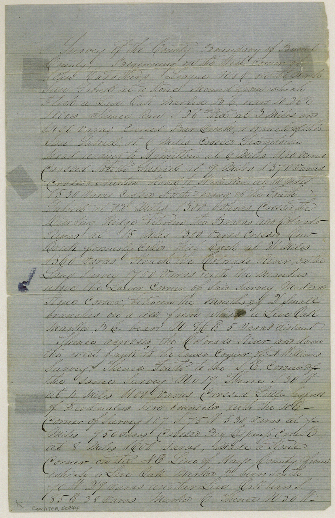
Burnet County Boundary File 1
Transcript of Fieldnotes of Boundaries of Burnet County, Description of the County Line thereof
-
Map/Doc
50844
-
Collection
General Map Collection
-
Counties
Burnet
-
Subjects
County Boundaries
-
Height x Width
12.8 x 8.3 inches
32.5 x 21.1 cm
Part of: General Map Collection
Orange County Working Sketch 48

Print $20.00
- Digital $50.00
Orange County Working Sketch 48
1991
Size 13.3 x 19.9 inches
Map/Doc 71380
Current Miscellaneous File 1

Print $12.00
- Digital $50.00
Current Miscellaneous File 1
1945
Size 11.3 x 8.8 inches
Map/Doc 73700
Castro County Rolled Sketch 7

Print $20.00
- Digital $50.00
Castro County Rolled Sketch 7
1908
Size 28.9 x 24.1 inches
Map/Doc 5417
Reagan County Rolled Sketch 28

Print $40.00
- Digital $50.00
Reagan County Rolled Sketch 28
1952
Size 64.1 x 46.5 inches
Map/Doc 9823
Ward County Rolled Sketch 19

Print $20.00
- Digital $50.00
Ward County Rolled Sketch 19
1949
Size 20.5 x 26.7 inches
Map/Doc 8161
San Patricio County Working Sketch 25

Print $20.00
- Digital $50.00
San Patricio County Working Sketch 25
1951
Size 20.3 x 25.4 inches
Map/Doc 63787
Menard County Rolled Sketch 12

Print $20.00
- Digital $50.00
Menard County Rolled Sketch 12
Size 14.4 x 21.7 inches
Map/Doc 6758
Titus County Sketch File 2

Print $4.00
- Digital $50.00
Titus County Sketch File 2
Size 8.2 x 10.1 inches
Map/Doc 38132
Medina County

Print $40.00
- Digital $50.00
Medina County
1915
Size 50.0 x 42.0 inches
Map/Doc 66925
Topographical Map of the Rio Grande, Sheet No. 13

Print $20.00
- Digital $50.00
Topographical Map of the Rio Grande, Sheet No. 13
1912
Map/Doc 89537
[Surveys in the Bexar District along the Balcones, Cibolo and Leon Creeks]
![63, [Surveys in the Bexar District along the Balcones, Cibolo and Leon Creeks], General Map Collection](https://historictexasmaps.com/wmedia_w700/maps/63.tif.jpg)
Print $3.00
- Digital $50.00
[Surveys in the Bexar District along the Balcones, Cibolo and Leon Creeks]
1842
Size 10.6 x 12.4 inches
Map/Doc 63
Southern Pacific Transportation Company Right of Way and Track Map - Main Line

Print $40.00
- Digital $50.00
Southern Pacific Transportation Company Right of Way and Track Map - Main Line
1918
Size 25.4 x 57.6 inches
Map/Doc 82858
You may also like
Maps of Gulf Intracoastal Waterway, Texas - Sabine River to the Rio Grande and connecting waterways including ship channels

Print $20.00
- Digital $50.00
Maps of Gulf Intracoastal Waterway, Texas - Sabine River to the Rio Grande and connecting waterways including ship channels
1966
Size 14.6 x 20.8 inches
Map/Doc 61993
Borden County Sketch File 10b

Print $40.00
- Digital $50.00
Borden County Sketch File 10b
Size 23.0 x 17.0 inches
Map/Doc 10936
Map of Caldwell County, Texas

Print $20.00
Map of Caldwell County, Texas
1879
Size 17.4 x 21.5 inches
Map/Doc 88914
Dallas County Boundary File 8 and 8a

Print $4.00
- Digital $50.00
Dallas County Boundary File 8 and 8a
Size 11.2 x 8.7 inches
Map/Doc 52311
Flight Mission No. BRA-16M, Frame 91, Jefferson County

Print $20.00
- Digital $50.00
Flight Mission No. BRA-16M, Frame 91, Jefferson County
1953
Size 18.7 x 22.5 inches
Map/Doc 85703

Brewster County Working Sketch 112

Print $20.00
- Digital $50.00
Brewster County Working Sketch 112
1982
Size 28.1 x 26.8 inches
Map/Doc 67712
University of Texas System University Lands

Print $20.00
- Digital $50.00
University of Texas System University Lands
1931
Size 23.2 x 17.5 inches
Map/Doc 93241
Kleberg County Boundary File 2b

Print $20.00
- Digital $50.00
Kleberg County Boundary File 2b
Size 8.0 x 28.9 inches
Map/Doc 64978
Current Miscellaneous File 101

Print $46.00
- Digital $50.00
Current Miscellaneous File 101
1931
Size 8.8 x 14.2 inches
Map/Doc 74357
Crockett County Rolled Sketch 80

Print $40.00
- Digital $50.00
Crockett County Rolled Sketch 80
1954
Size 24.8 x 55.5 inches
Map/Doc 8725
Map of the Texas & Pacific Railway Company Reserve west of the Colorado River

Print $40.00
- Digital $50.00
Map of the Texas & Pacific Railway Company Reserve west of the Colorado River
1877
Size 48.9 x 59.2 inches
Map/Doc 2233