Crosby County Sketch File 12
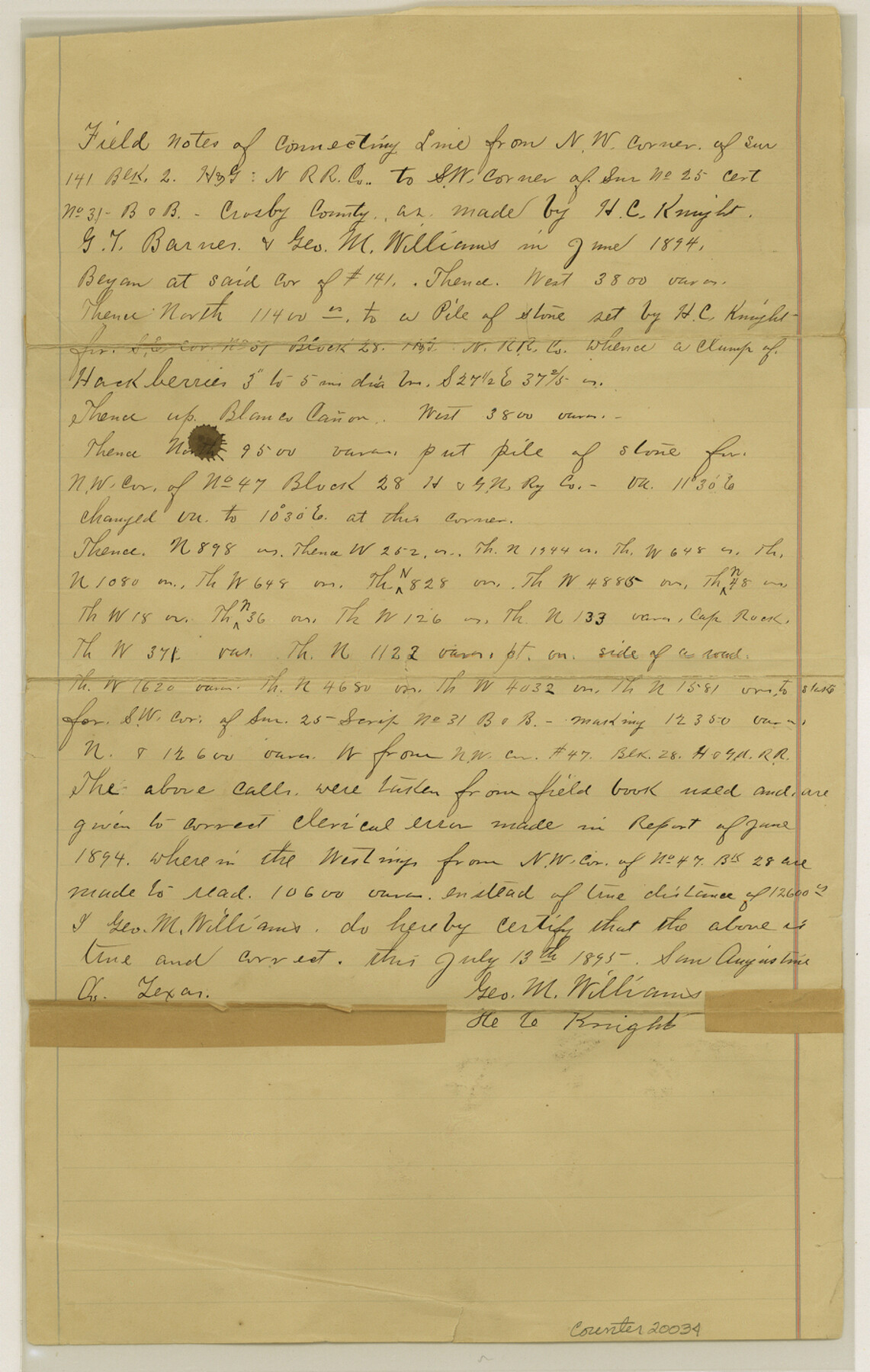
[Field notes of connecting line from northwest corner of survey 141, Block 2, H. & G. N. RR. Co. to southwest corner of survey 25, certificate no. 31]
-
Map/Doc
20034
-
Collection
General Map Collection
-
Object Dates
1895/7/13 (Creation Date)
1895/12/5 (File Date)
-
People and Organizations
Geo. M. Williams (Surveyor/Engineer)
H.C. Knight (Surveyor/Engineer)
G.T. Barnes (Surveyor/Engineer)
-
Counties
Crosby
-
Subjects
Surveying Sketch File
-
Height x Width
14.3 x 9.1 inches
36.3 x 23.1 cm
-
Medium
paper, manuscript
-
Features
Blanco Canon
Part of: General Map Collection
Map of Red River Division of the International & Great Northern Railroad

Print $40.00
- Digital $50.00
Map of Red River Division of the International & Great Northern Railroad
Size 24.1 x 107.0 inches
Map/Doc 64476
Angelina County Working Sketch 35

Print $20.00
- Digital $50.00
Angelina County Working Sketch 35
1957
Size 27.4 x 29.6 inches
Map/Doc 67118
Pecos County Working Sketch 56

Print $40.00
- Digital $50.00
Pecos County Working Sketch 56
1949
Size 29.9 x 57.4 inches
Map/Doc 71528
Flight Mission No. DQO-8K, Frame 142, Galveston County

Print $20.00
- Digital $50.00
Flight Mission No. DQO-8K, Frame 142, Galveston County
1952
Size 18.6 x 22.3 inches
Map/Doc 85204

Burnet County Rolled Sketch 2

Print $20.00
- Digital $50.00
Burnet County Rolled Sketch 2
1948
Size 15.5 x 30.5 inches
Map/Doc 5354
Williamson County Boundary File 3

Print $20.00
- Digital $50.00
Williamson County Boundary File 3
Size 18.5 x 23.6 inches
Map/Doc 60012
Austin County Boundary File 6

Print $16.00
- Digital $50.00
Austin County Boundary File 6
Size 11.1 x 8.4 inches
Map/Doc 50255
Trinity River, Daugherty Lake Sheet/East Fork of Trinity River

Print $20.00
- Digital $50.00
Trinity River, Daugherty Lake Sheet/East Fork of Trinity River
1920
Size 41.9 x 30.1 inches
Map/Doc 65191
Houston County Working Sketch 25

Print $40.00
- Digital $50.00
Houston County Working Sketch 25
1983
Size 43.6 x 89.0 inches
Map/Doc 66255
Ochiltree County Sketch File 4

Print $10.00
- Digital $50.00
Ochiltree County Sketch File 4
1915
Size 11.3 x 8.7 inches
Map/Doc 33179
Reagan County Sketch File 16

Print $8.00
- Digital $50.00
Reagan County Sketch File 16
1932
Size 11.1 x 7.7 inches
Map/Doc 35002
You may also like
Presidio County Working Sketch 105

Print $20.00
- Digital $50.00
Presidio County Working Sketch 105
1980
Size 27.5 x 27.5 inches
Map/Doc 71782
Leon County Rolled Sketch 14

Print $20.00
- Digital $50.00
Leon County Rolled Sketch 14
1976
Size 33.4 x 27.9 inches
Map/Doc 9432
Navigation Maps of Gulf Intracoastal Waterway, Port Arthur to Brownsville, Texas

Print $4.00
- Digital $50.00
Navigation Maps of Gulf Intracoastal Waterway, Port Arthur to Brownsville, Texas
1951
Size 16.7 x 21.5 inches
Map/Doc 65434
Live Oak County Sketch File 29

Print $6.00
- Digital $50.00
Live Oak County Sketch File 29
1922
Size 13.5 x 8.7 inches
Map/Doc 30319
Zavala County Working Sketch 22

Print $40.00
- Digital $50.00
Zavala County Working Sketch 22
1980
Size 70.4 x 43.5 inches
Map/Doc 62097

Uvalde County Working Sketch 49

Print $20.00
- Digital $50.00
Uvalde County Working Sketch 49
1980
Size 35.4 x 44.7 inches
Map/Doc 72119
Callahan County Sketch File 10 1/2

Print $4.00
- Digital $50.00
Callahan County Sketch File 10 1/2
1889
Size 14.4 x 8.7 inches
Map/Doc 35885
Borden County Sketch File 4

Print $24.00
- Digital $50.00
Borden County Sketch File 4
1903
Size 8.8 x 7.8 inches
Map/Doc 14707
Real County Working Sketch 72

Print $20.00
- Digital $50.00
Real County Working Sketch 72
1976
Size 47.3 x 43.3 inches
Map/Doc 71964
Map of Hamilton County

Print $20.00
- Digital $50.00
Map of Hamilton County
1872
Size 14.6 x 21.7 inches
Map/Doc 3620
Knox County Sketch File 14

Print $12.00
- Digital $50.00
Knox County Sketch File 14
1892
Size 11.1 x 8.5 inches
Map/Doc 29235