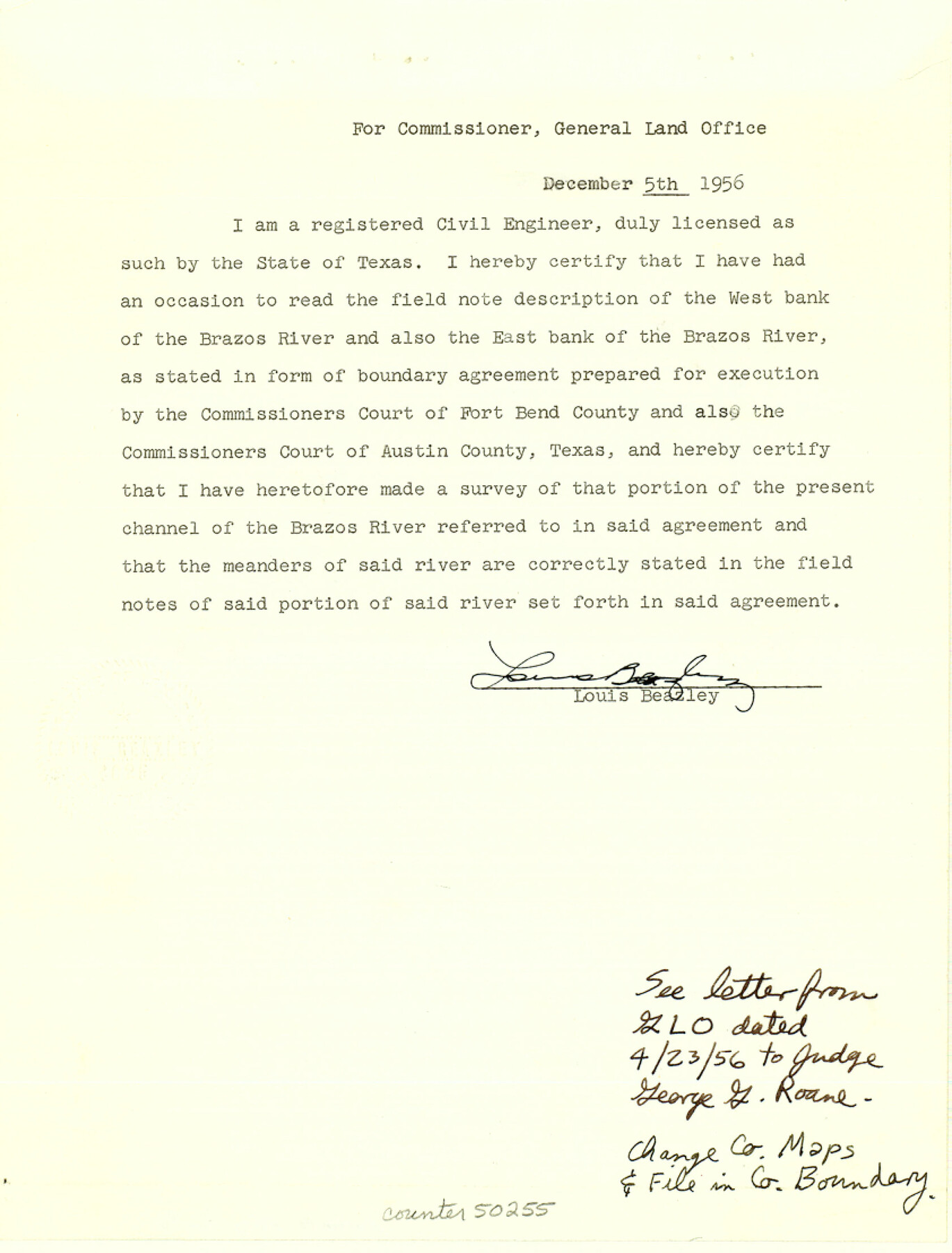
Austin County Boundary File 6
Fieldnotes and agreement on the course of the Brazos River channel between Austin and Fort Bend Counties
-
Map/Doc
50255
-
Collection
General Map Collection
-
Counties
Austin
-
Subjects
County Boundaries
-
Height x Width
11.1 x 8.4 inches
28.2 x 21.3 cm
Part of: General Map Collection
Coleman County Working Sketch 23

Print $20.00
- Digital $50.00
Coleman County Working Sketch 23
1958
Size 30.4 x 29.5 inches
Map/Doc 68276
Hudspeth County Working Sketch 51

Print $20.00
- Digital $50.00
Hudspeth County Working Sketch 51
Size 32.8 x 24.5 inches
Map/Doc 66336
Houston Ship Channel, Atkinson Island to Alexander Island

Print $40.00
- Digital $50.00
Houston Ship Channel, Atkinson Island to Alexander Island
1975
Size 36.2 x 50.4 inches
Map/Doc 69903
Cass County Sketch File 22

Print $8.00
- Digital $50.00
Cass County Sketch File 22
1849
Size 12.8 x 7.8 inches
Map/Doc 17427
Liberty County Working Sketch 74

Print $20.00
- Digital $50.00
Liberty County Working Sketch 74
1979
Size 38.8 x 35.4 inches
Map/Doc 70534
Brewster County Rolled Sketch 156

Print $156.00
- Digital $50.00
Brewster County Rolled Sketch 156
2005
Map/Doc 85390
Flight Mission No. BRA-7M, Frame 15, Jefferson County

Print $20.00
- Digital $50.00
Flight Mission No. BRA-7M, Frame 15, Jefferson County
1953
Size 18.6 x 22.3 inches
Map/Doc 85466
La Salle County Sketch File 22

Print $4.00
- Digital $50.00
La Salle County Sketch File 22
1875
Size 12.8 x 8.2 inches
Map/Doc 29528
Galveston County NRC Article 33.136 Sketch 68

Print $34.00
- Digital $50.00
Galveston County NRC Article 33.136 Sketch 68
2008
Size 24.0 x 36.0 inches
Map/Doc 94840
[Map showing the location of the Pecos Valley Railway through H. &. G. N. R.R. Co. Land in Reeves Co., Texas]
![64707, [Map showing the location of the Pecos Valley Railway through H. &. G. N. R.R. Co. Land in Reeves Co., Texas], General Map Collection](https://historictexasmaps.com/wmedia_w700/maps/64707.tif.jpg)
Print $40.00
- Digital $50.00
[Map showing the location of the Pecos Valley Railway through H. &. G. N. R.R. Co. Land in Reeves Co., Texas]
1891
Size 39.1 x 123.6 inches
Map/Doc 64707
Brazoria County Sketch File 6a

Print $40.00
- Digital $50.00
Brazoria County Sketch File 6a
1862
Size 17.6 x 12.6 inches
Map/Doc 10949
Duval County Sketch File 34

Print $20.00
- Digital $50.00
Duval County Sketch File 34
Size 28.4 x 36.9 inches
Map/Doc 11391
You may also like
Travis County Sketch File 77

Print $26.00
- Digital $50.00
Travis County Sketch File 77
2004
Size 11.0 x 8.5 inches
Map/Doc 83254
Loving County Rolled Sketch 1

Print $40.00
- Digital $50.00
Loving County Rolled Sketch 1
Size 42.5 x 79.5 inches
Map/Doc 9460
Eastland County Working Sketch 43

Print $20.00
- Digital $50.00
Eastland County Working Sketch 43
1979
Size 19.7 x 31.0 inches
Map/Doc 68824
Archer County Sketch File 27

Print $40.00
- Digital $50.00
Archer County Sketch File 27
Size 19.1 x 21.1 inches
Map/Doc 10833
Map of Survey in Dimmit and Webb Counties

Print $40.00
- Digital $50.00
Map of Survey in Dimmit and Webb Counties
1913
Size 31.3 x 71.0 inches
Map/Doc 75829

Cottle County Sketch File 17

Print $6.00
- Digital $50.00
Cottle County Sketch File 17
1903
Size 7.2 x 10.9 inches
Map/Doc 19554
Hardeman County Sketch File 4

Print $6.00
- Digital $50.00
Hardeman County Sketch File 4
Size 9.3 x 8.2 inches
Map/Doc 24991
Greer County Sketch File 11

Print $6.00
- Digital $50.00
Greer County Sketch File 11
Size 14.2 x 8.8 inches
Map/Doc 24532
Dawson County Rolled Sketch 3

Print $20.00
- Digital $50.00
Dawson County Rolled Sketch 3
1903
Size 20.9 x 36.8 inches
Map/Doc 8770
Corpus Christi Bay

Print $20.00
- Digital $50.00
Corpus Christi Bay
1971
Size 36.2 x 47.6 inches
Map/Doc 73473
Smith County Sketch File 4

Print $4.00
- Digital $50.00
Smith County Sketch File 4
1853
Size 10.3 x 8.1 inches
Map/Doc 36752