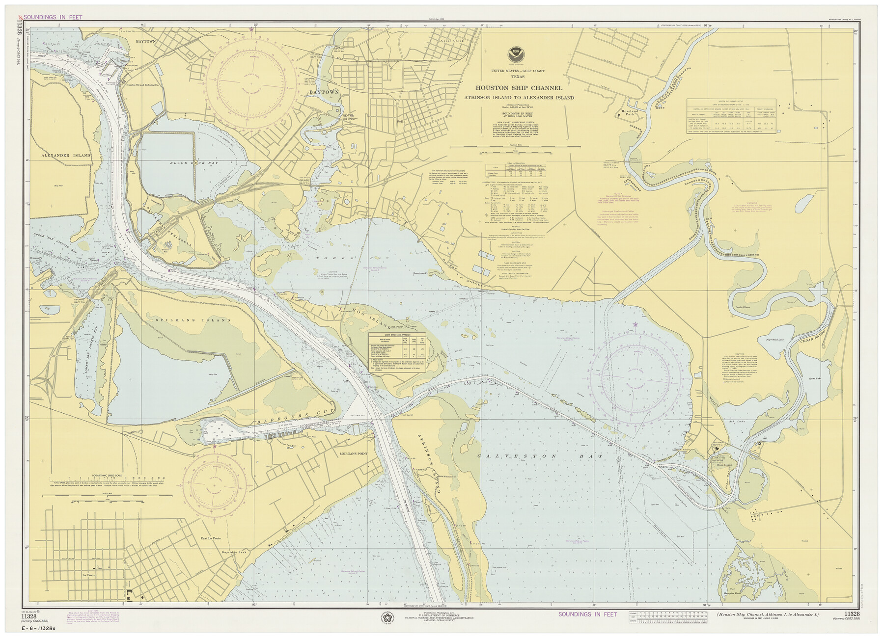
Houston Ship Channel, Atkinson Island to Alexander Island
K-2-588a
-
Map/Doc
69903
-
Collection
General Map Collection
-
Object Dates
3/29/1975 (Creation Date)
-
Counties
Harris Chambers
-
Subjects
Nautical Charts
-
Height x Width
36.2 x 50.4 inches
92.0 x 128.0 cm
Part of: General Map Collection
Nolan County Working Sketch 1

Print $20.00
- Digital $50.00
Nolan County Working Sketch 1
1928
Size 17.9 x 17.5 inches
Map/Doc 71292
Crosby County Sketch File 12

Print $4.00
- Digital $50.00
Crosby County Sketch File 12
1895
Size 14.3 x 9.1 inches
Map/Doc 20034
Llano County Sketch File 1

Print $24.00
- Digital $50.00
Llano County Sketch File 1
Size 8.9 x 7.7 inches
Map/Doc 30345
Val Verde County Working Sketch 117

Print $20.00
- Digital $50.00
Val Verde County Working Sketch 117
1993
Size 20.9 x 38.2 inches
Map/Doc 82841
Map of The Surveyed Part of Peters Colony Texas

Print $40.00
- Digital $50.00
Map of The Surveyed Part of Peters Colony Texas
1852
Size 56.5 x 41.0 inches
Map/Doc 1966
Map of Houston & Overton Branch Railroad

Print $40.00
- Digital $50.00
Map of Houston & Overton Branch Railroad
1877
Size 22.3 x 110.1 inches
Map/Doc 64460
Henderson County Working Sketch 12

Print $20.00
- Digital $50.00
Henderson County Working Sketch 12
1915
Size 23.3 x 24.9 inches
Map/Doc 66145
Colorado County Sketch File 18

Print $40.00
- Digital $50.00
Colorado County Sketch File 18
1897
Size 12.5 x 15.8 inches
Map/Doc 18950
Map of South America to illustrate Olney's school geography

Print $20.00
- Digital $50.00
Map of South America to illustrate Olney's school geography
1844
Size 12.1 x 9.5 inches
Map/Doc 93545
Hydrography Survey H-6395 Off Coast of Texas, Aransas Pass to Corpus Christi Pass in the Gulf of Mexico

Print $40.00
- Digital $50.00
Hydrography Survey H-6395 Off Coast of Texas, Aransas Pass to Corpus Christi Pass in the Gulf of Mexico
1938
Size 56.1 x 33.6 inches
Map/Doc 2696
Texas, San Antonio Bay, Hynes Bay

Print $40.00
- Digital $50.00
Texas, San Antonio Bay, Hynes Bay
1934
Size 33.0 x 48.9 inches
Map/Doc 69998
Texas-United States Boundary Line 1

Print $4.00
- Digital $50.00
Texas-United States Boundary Line 1
1843
Size 12.6 x 7.8 inches
Map/Doc 74974
You may also like
Sketch Showing Division Fence Shelton-Matador

Print $20.00
- Digital $50.00
Sketch Showing Division Fence Shelton-Matador
Size 21.3 x 24.1 inches
Map/Doc 91446
Washington County Sketch File 6

Print $20.00
- Digital $50.00
Washington County Sketch File 6
1901
Size 24.7 x 26.0 inches
Map/Doc 12602
Rockwall County Boundary File 9a

Print $4.00
- Digital $50.00
Rockwall County Boundary File 9a
Size 14.0 x 8.8 inches
Map/Doc 58437
Leon County, Texas

Print $20.00
- Digital $50.00
Leon County, Texas
1879
Size 25.6 x 22.3 inches
Map/Doc 563
Bastrop County

Print $40.00
- Digital $50.00
Bastrop County
1917
Size 49.7 x 42.0 inches
Map/Doc 4796
Bandera County Working Sketch 33

Print $20.00
- Digital $50.00
Bandera County Working Sketch 33
1961
Size 22.4 x 28.8 inches
Map/Doc 67629
[Blocks C31, C32, C36-C39]
![91867, [Blocks C31, C32, C36-C39], Twichell Survey Records](https://historictexasmaps.com/wmedia_w700/maps/91867-1.tif.jpg)
Print $20.00
- Digital $50.00
[Blocks C31, C32, C36-C39]
Size 15.6 x 16.0 inches
Map/Doc 91867
United States - Gulf Coast - From Latitude 26° 33' to the Rio Grande Texas

Print $20.00
- Digital $50.00
United States - Gulf Coast - From Latitude 26° 33' to the Rio Grande Texas
1913
Size 27.8 x 18.4 inches
Map/Doc 72831
K&E Compensating Polar Planimeter

K&E Compensating Polar Planimeter
1972
Size 2.1 x 11.6 inches
Map/Doc 97302
Tyler County Working Sketch Graphic Index

Print $20.00
- Digital $50.00
Tyler County Working Sketch Graphic Index
1944
Size 47.4 x 39.6 inches
Map/Doc 76719
Hockley County Rolled Sketch 6

Print $40.00
- Digital $50.00
Hockley County Rolled Sketch 6
Size 30.6 x 48.2 inches
Map/Doc 6216