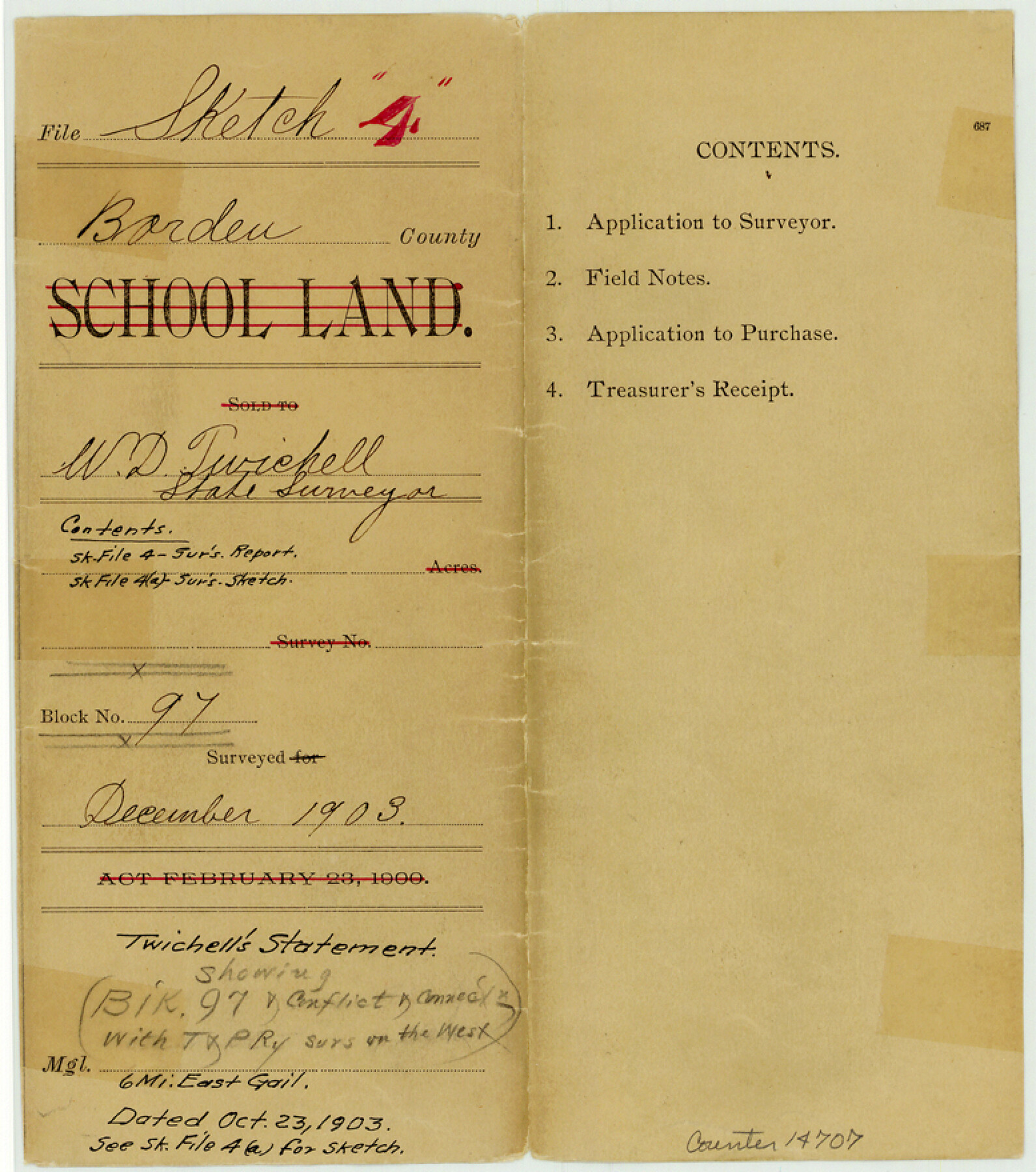
Borden County Sketch File 4
[Twichell's statement regarding Block 97 and conflict and connections with T. & P. Ry. surveys on the west]
-
Map/Doc
14707
-
Collection
General Map Collection
-
Object Dates
1903/10/23 (Creation Date)
1903 (File Date)
-
People and Organizations
W.D. Twichell (Surveyor/Engineer)
-
Counties
Borden
-
Subjects
Surveying Sketch File
-
Height x Width
8.8 x 7.8 inches
22.4 x 19.8 cm
-
Medium
multi-page, multi-format
-
Comments
See Borden County Sketch File 4a (10934) for sketch.
-
Features
Mushaway Mountain
Bull Creek
Mesquite Creek
Related maps
Borden County Sketch File 4a

Print $40.00
- Digital $50.00
Borden County Sketch File 4a
Size 27.1 x 18.1 inches
Map/Doc 10934
Part of: General Map Collection
Brewster County Rolled Sketch 114

Print $20.00
- Digital $50.00
Brewster County Rolled Sketch 114
1964
Size 12.0 x 18.4 inches
Map/Doc 5278
Upton County Rolled Sketch 14

Print $20.00
- Digital $50.00
Upton County Rolled Sketch 14
Size 43.2 x 32.0 inches
Map/Doc 10038
Archer County Working Sketch 21

Print $20.00
- Digital $50.00
Archer County Working Sketch 21
1976
Size 18.2 x 27.4 inches
Map/Doc 67162
[Aransas National Wildlife Refuge]
![3119, [Aransas National Wildlife Refuge], General Map Collection](https://historictexasmaps.com/wmedia_w700/maps/3119-1.tif.jpg)
Print $40.00
- Digital $50.00
[Aransas National Wildlife Refuge]
1952
Size 55.9 x 43.4 inches
Map/Doc 3119
[FT. W. & R. G. Ry. Right of Way Map, Winchell to Brady, McCulloch County, Texas]
![61411, [FT. W. & R. G. Ry. Right of Way Map, Winchell to Brady, McCulloch County, Texas], General Map Collection](https://historictexasmaps.com/wmedia_w700/maps/61411.tif.jpg)
Print $20.00
- Digital $50.00
[FT. W. & R. G. Ry. Right of Way Map, Winchell to Brady, McCulloch County, Texas]
1918
Size 37.0 x 26.9 inches
Map/Doc 61411
Trinity River, Levee Improvement Districts Widths of Floodways/Chambers Creek

Print $4.00
- Digital $50.00
Trinity River, Levee Improvement Districts Widths of Floodways/Chambers Creek
1921
Size 18.6 x 28.3 inches
Map/Doc 65247
Culberson County Sketch File 7

Print $8.00
- Digital $50.00
Culberson County Sketch File 7
1888
Size 14.5 x 8.8 inches
Map/Doc 20138
Falls County Sketch File 18

Print $4.00
- Digital $50.00
Falls County Sketch File 18
Size 10.3 x 8.2 inches
Map/Doc 22380
Cameron County Rolled Sketch Z7

Print $20.00
- Digital $50.00
Cameron County Rolled Sketch Z7
1937
Size 28.3 x 34.1 inches
Map/Doc 5405
Dimmit County Sketch File 38

Print $40.00
- Digital $50.00
Dimmit County Sketch File 38
1896
Size 14.8 x 16.9 inches
Map/Doc 21163
Milam County Boundary File 6c

Print $2.00
- Digital $50.00
Milam County Boundary File 6c
Size 11.2 x 8.5 inches
Map/Doc 57250
Mitchell County Sketch File 11

Print $6.00
- Digital $50.00
Mitchell County Sketch File 11
1910
Size 11.2 x 8.8 inches
Map/Doc 31700
You may also like
Henderson County Rolled Sketch 11

Print $20.00
- Digital $50.00
Henderson County Rolled Sketch 11
1915
Size 29.0 x 42.6 inches
Map/Doc 76151
General Highway Map. Detail of Cities and Towns in Travis County, Texas

Print $20.00
General Highway Map. Detail of Cities and Towns in Travis County, Texas
1961
Size 18.2 x 24.9 inches
Map/Doc 79681
[Cotton Belt, St. Louis Southwestern Railway of Texas, Alignment through Smith County]
![64380, [Cotton Belt, St. Louis Southwestern Railway of Texas, Alignment through Smith County], General Map Collection](https://historictexasmaps.com/wmedia_w700/maps/64380.tif.jpg)
Print $20.00
- Digital $50.00
[Cotton Belt, St. Louis Southwestern Railway of Texas, Alignment through Smith County]
1903
Size 21.4 x 29.7 inches
Map/Doc 64380
Montgomery County Sketch File 34

Print $8.00
- Digital $50.00
Montgomery County Sketch File 34
1949
Size 14.4 x 8.7 inches
Map/Doc 31904
Aransas County Working Sketch 18

Print $20.00
- Digital $50.00
Aransas County Working Sketch 18
1961
Size 36.0 x 30.7 inches
Map/Doc 67185
Hood County Boundary File 41

Print $6.00
- Digital $50.00
Hood County Boundary File 41
Size 11.2 x 8.8 inches
Map/Doc 55041
Kleberg County Rolled Sketch 10-24

Print $20.00
- Digital $50.00
Kleberg County Rolled Sketch 10-24
1952
Size 41.7 x 36.0 inches
Map/Doc 9386
Flight Mission No. DQO-8K, Frame 54, Galveston County

Print $20.00
- Digital $50.00
Flight Mission No. DQO-8K, Frame 54, Galveston County
1952
Size 18.5 x 22.2 inches
Map/Doc 85161
Survey of 77 Blocks, State University Land

Survey of 77 Blocks, State University Land
1884
Size 13.5 x 8.5 inches
Map/Doc 81693
Dallam County

Print $40.00
- Digital $50.00
Dallam County
1926
Size 39.9 x 48.6 inches
Map/Doc 95474
Flight Mission No. DIX-10P, Frame 82, Aransas County

Print $20.00
- Digital $50.00
Flight Mission No. DIX-10P, Frame 82, Aransas County
1956
Size 18.8 x 22.4 inches
Map/Doc 83943
Robertson County Sketch File 4

Print $12.00
Robertson County Sketch File 4
1862
Size 11.0 x 8.0 inches
Map/Doc 35352