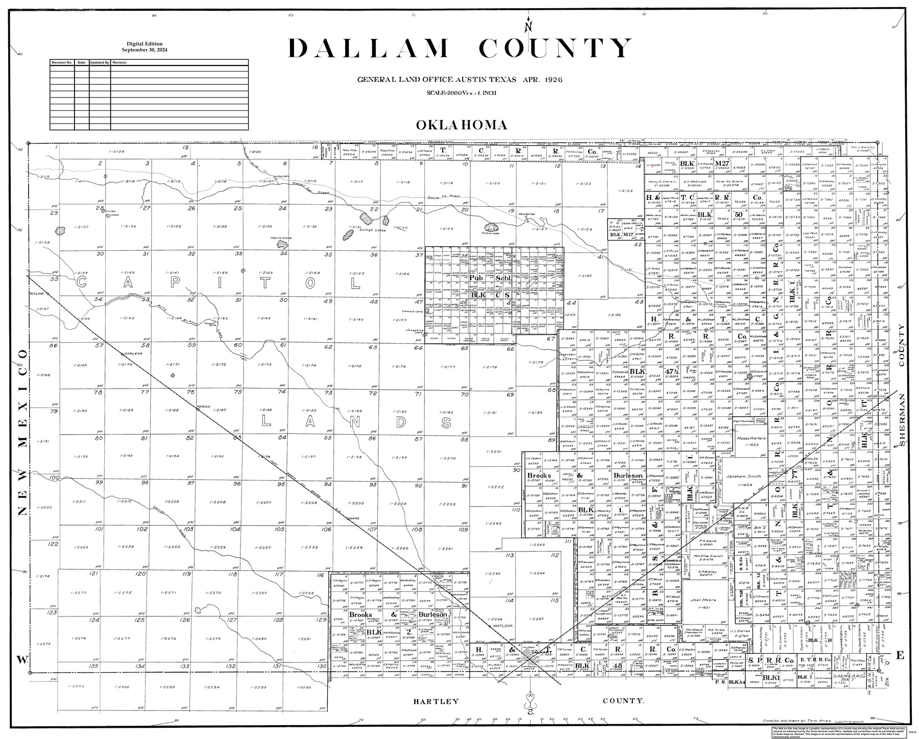
Dallam County
General Land Office Official County Map
-
Map/Doc
95474
-
Collection
General Map Collection
-
Object Dates
4/1926 (Creation Date)
9/30/2024 (Revision Date)
-
People and Organizations
Cheyenne Betancourt (Draftsman)
-
Counties
Dallam
-
Subjects
County OCM
-
Height x Width
39.9 x 48.6 inches
101.4 x 123.4 cm
-
Medium
digital image
-
Scale
1" = 2000 varas
Part of: General Map Collection
Flight Mission No. DQO-1K, Frame 115, Galveston County

Print $20.00
- Digital $50.00
Flight Mission No. DQO-1K, Frame 115, Galveston County
1952
Size 18.9 x 22.5 inches
Map/Doc 84993
[Right of Way & Track Map, The Texas & Pacific Ry. Co. Main Line]
![64670, [Right of Way & Track Map, The Texas & Pacific Ry. Co. Main Line], General Map Collection](https://historictexasmaps.com/wmedia_w700/maps/64670.tif.jpg)
Print $20.00
- Digital $50.00
[Right of Way & Track Map, The Texas & Pacific Ry. Co. Main Line]
Size 11.0 x 18.5 inches
Map/Doc 64670
Galveston County Working Sketch 24

Print $20.00
- Digital $50.00
Galveston County Working Sketch 24
1939
Size 16.6 x 19.6 inches
Map/Doc 69361
Flight Mission No. BRA-16M, Frame 107, Jefferson County

Print $20.00
- Digital $50.00
Flight Mission No. BRA-16M, Frame 107, Jefferson County
1953
Size 18.5 x 22.3 inches
Map/Doc 85719
Erath County Working Sketch 7

Print $20.00
- Digital $50.00
Erath County Working Sketch 7
1921
Size 15.8 x 16.1 inches
Map/Doc 69088
Map of Kimble County, 1860

Print $20.00
- Digital $50.00
Map of Kimble County, 1860
1860
Size 20.7 x 30.5 inches
Map/Doc 3769
Burnet County Working Sketch 15

Print $20.00
- Digital $50.00
Burnet County Working Sketch 15
1979
Size 38.2 x 30.4 inches
Map/Doc 67858
Presidio County Rolled Sketch 42

Print $20.00
- Digital $50.00
Presidio County Rolled Sketch 42
1907
Size 31.7 x 19.0 inches
Map/Doc 7339

Pecos County Rolled Sketch 158

Print $20.00
- Digital $50.00
Pecos County Rolled Sketch 158
1961
Size 21.9 x 27.4 inches
Map/Doc 7284

Map of section no. 3 of a survey of Padre Island made for the Office of the Attorney General of the State of Texas

Print $40.00
- Digital $50.00
Map of section no. 3 of a survey of Padre Island made for the Office of the Attorney General of the State of Texas
1941
Size 49.6 x 40.2 inches
Map/Doc 2259
You may also like
Henderson County

Print $40.00
- Digital $50.00
Henderson County
1988
Size 35.3 x 69.7 inches
Map/Doc 95528
Map of the Northern Part of Houston District

Print $20.00
- Digital $50.00
Map of the Northern Part of Houston District
1849
Size 26.4 x 26.7 inches
Map/Doc 3223
Angelina County Sketch File 25

Print $8.00
- Digital $50.00
Angelina County Sketch File 25
1894
Size 7.0 x 10.2 inches
Map/Doc 13069
Flight Mission No. CRC-2R, Frame 178, Chambers County

Print $20.00
- Digital $50.00
Flight Mission No. CRC-2R, Frame 178, Chambers County
1956
Size 18.6 x 22.4 inches
Map/Doc 84756
Rusk County Working Sketch 27

Print $20.00
- Digital $50.00
Rusk County Working Sketch 27
1937
Size 35.6 x 29.3 inches
Map/Doc 63663
Gonzales County Working Sketch 5

Print $20.00
- Digital $50.00
Gonzales County Working Sketch 5
1980
Size 31.2 x 43.6 inches
Map/Doc 63221
Brewster County Working Sketch 18

Print $20.00
- Digital $50.00
Brewster County Working Sketch 18
1934
Size 35.9 x 37.8 inches
Map/Doc 67552
Brewster County Rolled Sketch 139

Print $20.00
- Digital $50.00
Brewster County Rolled Sketch 139
1982
Size 24.4 x 38.0 inches
Map/Doc 5307
Childress County Boundary File 3a

Print $80.00
- Digital $50.00
Childress County Boundary File 3a
Size 30.7 x 70.1 inches
Map/Doc 51354
Bee County Sketch File 6

Print $6.00
- Digital $50.00
Bee County Sketch File 6
1860
Size 12.3 x 7.7 inches
Map/Doc 14272
Wise County Sketch File 51

Print $2.00
- Digital $50.00
Wise County Sketch File 51
Size 8.5 x 3.9 inches
Map/Doc 40618
Crane County Sketch File 15 (C-1)

Print $6.00
- Digital $50.00
Crane County Sketch File 15 (C-1)
1925
Size 8.8 x 15.4 inches
Map/Doc 19579