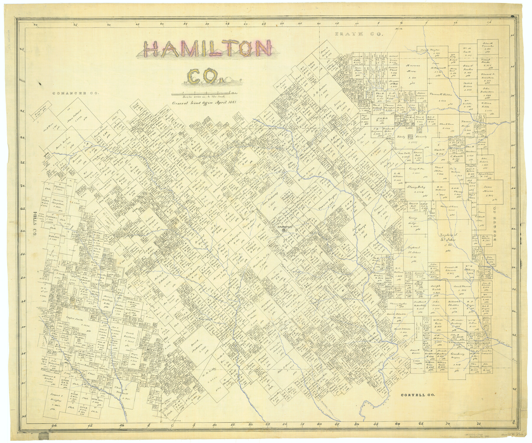
Hamilton Co.
-
Map/Doc
4968
-
Collection
General Map Collection
-
Object Dates
1887 (Creation Date)
-
People and Organizations
Texas General Land Office (Publisher)
-
Counties
Hamilton
-
Subjects
County
-
Height x Width
36.3 x 43.6 inches
92.2 x 110.7 cm
Part of: General Map Collection
[Surveys along Eight Mile Creek, Harrison District]
![278, [Surveys along Eight Mile Creek, Harrison District], General Map Collection](https://historictexasmaps.com/wmedia_w700/maps/278.tif.jpg)
Print $3.00
- Digital $50.00
[Surveys along Eight Mile Creek, Harrison District]
Size 12.6 x 9.3 inches
Map/Doc 278
Matagorda County Rolled Sketch 18

Print $20.00
- Digital $50.00
Matagorda County Rolled Sketch 18
1838
Size 35.7 x 30.8 inches
Map/Doc 6685
Maps of Gulf Intracoastal Waterway, Texas - Sabine River to the Rio Grande and connecting waterways including ship channels

Print $20.00
- Digital $50.00
Maps of Gulf Intracoastal Waterway, Texas - Sabine River to the Rio Grande and connecting waterways including ship channels
1966
Size 14.6 x 22.3 inches
Map/Doc 61934
Zavala County Working Sketch 21

Print $20.00
- Digital $50.00
Zavala County Working Sketch 21
1979
Size 23.0 x 18.0 inches
Map/Doc 62096
Presidio County Sketch File 31

Print $20.00
- Digital $50.00
Presidio County Sketch File 31
Size 11.4 x 20.8 inches
Map/Doc 11712
Panola County Sketch File 4

Print $4.00
- Digital $50.00
Panola County Sketch File 4
1860
Size 8.9 x 8.9 inches
Map/Doc 33449
Map of Kerr County Texas

Print $20.00
- Digital $50.00
Map of Kerr County Texas
1879
Size 20.3 x 28.3 inches
Map/Doc 3763
Fannin County Boundary File 1a

Print $40.00
- Digital $50.00
Fannin County Boundary File 1a
1882
Size 36.5 x 9.5 inches
Map/Doc 53279
Wise County Sketch File 5

Print $6.00
- Digital $50.00
Wise County Sketch File 5
1856
Size 8.2 x 14.0 inches
Map/Doc 40531
Aransas County NRC Article 33.136 Sketch 10

Print $26.00
- Digital $50.00
Aransas County NRC Article 33.136 Sketch 10
Size 24.2 x 36.0 inches
Map/Doc 95016
Office sketch of surveys on St. Joseph Island and Mustang Island in Aransas & Nueces Cos.

Print $20.00
- Digital $50.00
Office sketch of surveys on St. Joseph Island and Mustang Island in Aransas & Nueces Cos.
1978
Size 42.8 x 17.7 inches
Map/Doc 2252
Map of Pecos and Reeves Counties

Print $40.00
- Digital $50.00
Map of Pecos and Reeves Counties
1873
Size 45.3 x 115.6 inches
Map/Doc 75930
You may also like

The Republic County of Liberty. January 20, 1841

Print $20.00
The Republic County of Liberty. January 20, 1841
2020
Size 19.9 x 21.7 inches
Map/Doc 96209
Hays County Sketch File 11

Print $4.00
- Digital $50.00
Hays County Sketch File 11
Size 10.3 x 8.2 inches
Map/Doc 26216
Neches River, Watershed of the Neches River

Print $6.00
- Digital $50.00
Neches River, Watershed of the Neches River
1925
Size 34.6 x 28.3 inches
Map/Doc 65085
Railroad Track Map, H&TCRRCo., Falls County, Texas

Print $4.00
- Digital $50.00
Railroad Track Map, H&TCRRCo., Falls County, Texas
1918
Size 11.5 x 18.4 inches
Map/Doc 62846
Flight Mission No. BRE-2P, Frame 132, Nueces County

Print $20.00
- Digital $50.00
Flight Mission No. BRE-2P, Frame 132, Nueces County
1956
Size 18.4 x 22.5 inches
Map/Doc 86805
Liberty County Working Sketch 18

Print $20.00
- Digital $50.00
Liberty County Working Sketch 18
1939
Size 20.5 x 20.4 inches
Map/Doc 70477

[Surveys in Power and Hewetson's Colony along the Aransas River, Middle Creek, Papalose Creek, and Blanco Creek]
![81, [Surveys in Power and Hewetson's Colony along the Aransas River, Middle Creek, Papalose Creek, and Blanco Creek], General Map Collection](https://historictexasmaps.com/wmedia_w700/maps/81.tif.jpg)
Print $20.00
- Digital $50.00
[Surveys in Power and Hewetson's Colony along the Aransas River, Middle Creek, Papalose Creek, and Blanco Creek]
1830
Size 21.6 x 21.2 inches
Map/Doc 81
Political Chief of Nacogdoches Correspondence with Various People (PCCVP)

Political Chief of Nacogdoches Correspondence with Various People (PCCVP)
Size 12.5 x 9.0 inches
Map/Doc 94264
Greer County Sketch File 3

Print $20.00
- Digital $50.00
Greer County Sketch File 3
Size 20.1 x 18.2 inches
Map/Doc 11583
Jefferson County Working Sketch 30a

Print $20.00
- Digital $50.00
Jefferson County Working Sketch 30a
1977
Size 17.8 x 21.2 inches
Map/Doc 66573