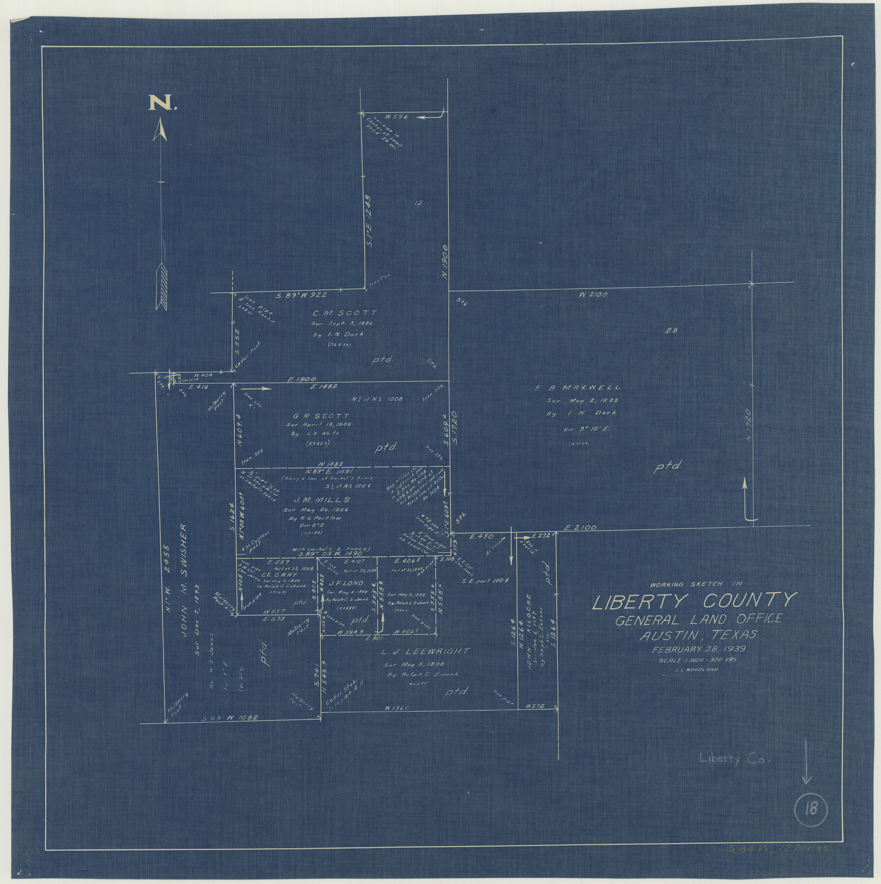
Liberty County Working Sketch 18
-
Map/Doc
70477
-
Collection
General Map Collection
-
Object Dates
2/28/1939 (Creation Date)
-
People and Organizations
J.L. Woodland (Draftsman)
-
Counties
Liberty
-
Subjects
Surveying Working Sketch
-
Height x Width
20.5 x 20.4 inches
52.1 x 51.8 cm
-
Scale
1" = 300 varas
Part of: General Map Collection
Map of University Land being a part of Block L, El Paso County, Texas

Print $20.00
- Digital $50.00
Map of University Land being a part of Block L, El Paso County, Texas
1945
Size 26.1 x 25.8 inches
Map/Doc 2423
Map of Cherokee County

Print $20.00
- Digital $50.00
Map of Cherokee County
1851
Size 24.6 x 18.3 inches
Map/Doc 3386
Flight Mission No. BQR-4K, Frame 69, Brazoria County

Print $20.00
- Digital $50.00
Flight Mission No. BQR-4K, Frame 69, Brazoria County
1952
Size 18.7 x 22.4 inches
Map/Doc 84002
Milam County Boundary File 5

Print $18.00
- Digital $50.00
Milam County Boundary File 5
Size 8.9 x 9.7 inches
Map/Doc 57223
Navarro County Sketch File 13

Print $22.00
- Digital $50.00
Navarro County Sketch File 13
Size 12.0 x 8.6 inches
Map/Doc 32324
[Right of Way & Track Map, The Texas & Pacific Ry. Co. Main Line]
![64678, [Right of Way & Track Map, The Texas & Pacific Ry. Co. Main Line], General Map Collection](https://historictexasmaps.com/wmedia_w700/maps/64678.tif.jpg)
Print $20.00
- Digital $50.00
[Right of Way & Track Map, The Texas & Pacific Ry. Co. Main Line]
Size 11.1 x 18.3 inches
Map/Doc 64678
Hardin County Sketch File 60

Print $8.00
- Digital $50.00
Hardin County Sketch File 60
Size 14.4 x 8.9 inches
Map/Doc 25234
Flight Mission No. BQR-7K, Frame 29, Brazoria County

Print $20.00
- Digital $50.00
Flight Mission No. BQR-7K, Frame 29, Brazoria County
1952
Size 19.6 x 25.0 inches
Map/Doc 84027

La Salle County Working Sketch 13

Print $20.00
- Digital $50.00
La Salle County Working Sketch 13
1930
Size 36.2 x 40.3 inches
Map/Doc 70314
Palo Pinto County Rolled Sketch 9

Print $40.00
- Digital $50.00
Palo Pinto County Rolled Sketch 9
Size 78.0 x 30.9 inches
Map/Doc 9675
Brewster County Sketch File 56

Print $14.00
- Digital $50.00
Brewster County Sketch File 56
2001
Size 11.0 x 8.5 inches
Map/Doc 16392
You may also like
Kimble County Working Sketch 51

Print $20.00
- Digital $50.00
Kimble County Working Sketch 51
1953
Size 36.3 x 40.1 inches
Map/Doc 70119
Brewster County Working Sketch 110

Print $40.00
- Digital $50.00
Brewster County Working Sketch 110
1982
Size 48.9 x 40.1 inches
Map/Doc 67710
Working Sketch in Crockett County

Print $20.00
- Digital $50.00
Working Sketch in Crockett County
1927
Size 25.6 x 22.7 inches
Map/Doc 90304
[Lgs. 180-183, 196-198, 105-112, 678-680, 699-701, 141-143]
![90155, [Lgs. 180-183, 196-198, 105-112, 678-680, 699-701, 141-143], Twichell Survey Records](https://historictexasmaps.com/wmedia_w700/maps/90155-1.tif.jpg)
Print $2.00
- Digital $50.00
[Lgs. 180-183, 196-198, 105-112, 678-680, 699-701, 141-143]
1913
Size 9.9 x 6.0 inches
Map/Doc 90155
Dimmit County Sketch File 10

Print $20.00
- Digital $50.00
Dimmit County Sketch File 10
Size 23.5 x 22.6 inches
Map/Doc 11338
Duval County Rolled Sketch 44

Print $40.00
- Digital $50.00
Duval County Rolled Sketch 44
1981
Size 36.5 x 90.5 inches
Map/Doc 8821
Zavala County Sketch File 9

Print $20.00
- Digital $50.00
Zavala County Sketch File 9
1884
Size 29.1 x 15.9 inches
Map/Doc 12727
Polk County Working Sketch 2

Print $20.00
- Digital $50.00
Polk County Working Sketch 2
1909
Size 27.7 x 20.1 inches
Map/Doc 71617
Gregg County Working Sketch 21

Print $20.00
- Digital $50.00
Gregg County Working Sketch 21
1966
Size 25.5 x 32.1 inches
Map/Doc 63288
Swisher County Sketch File 11

Print $58.00
- Digital $50.00
Swisher County Sketch File 11
1917
Size 9.1 x 8.3 inches
Map/Doc 37633
Duval County Working Sketch 47

Print $20.00
- Digital $50.00
Duval County Working Sketch 47
1981
Size 20.8 x 30.9 inches
Map/Doc 68771
