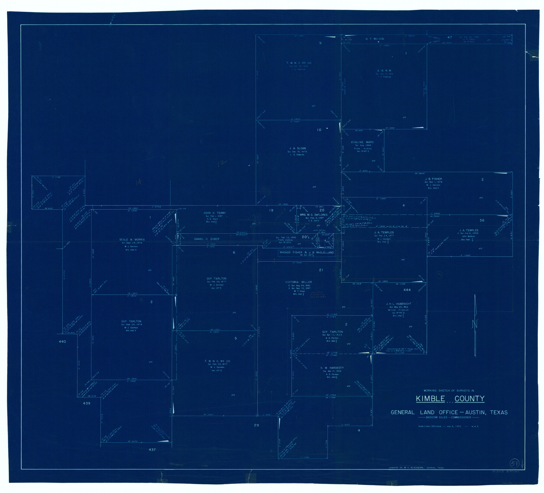
Kimble County Working Sketch 51
-
Map/Doc
70119
-
Collection
General Map Collection
-
Object Dates
7/6/1953 (Creation Date)
-
People and Organizations
Herman H. Forbes (Draftsman)
-
Counties
Kimble
-
Subjects
Surveying Working Sketch
-
Height x Width
36.3 x 40.1 inches
92.2 x 101.9 cm
-
Scale
1" = 300 varas
Part of: General Map Collection
Flight Mission No. DQN-1K, Frame 105, Calhoun County

Print $20.00
- Digital $50.00
Flight Mission No. DQN-1K, Frame 105, Calhoun County
1953
Size 18.4 x 22.2 inches
Map/Doc 84172
Interfaith's Official Map: The Woodlands, a real hometown for people and companies

Interfaith's Official Map: The Woodlands, a real hometown for people and companies
1997
Size 36.7 x 22.5 inches
Map/Doc 94285

Flight Mission No. CRK-3P, Frame 64, Refugio County

Print $20.00
- Digital $50.00
Flight Mission No. CRK-3P, Frame 64, Refugio County
1956
Size 18.7 x 22.5 inches
Map/Doc 86906
[The S.K. Ry. of Texas, State Line to Pecos, Reeves Co., Texas]
![64161, [The S.K. Ry. of Texas, State Line to Pecos, Reeves Co., Texas], General Map Collection](https://historictexasmaps.com/wmedia_w700/maps/64161.tif.jpg)
Print $40.00
- Digital $50.00
[The S.K. Ry. of Texas, State Line to Pecos, Reeves Co., Texas]
1910
Size 19.2 x 120.9 inches
Map/Doc 64161
[Surveys in the Bexar District along the Frio and Leona Rivers]
![136, [Surveys in the Bexar District along the Frio and Leona Rivers], General Map Collection](https://historictexasmaps.com/wmedia_w700/maps/136.tif.jpg)
Print $20.00
- Digital $50.00
[Surveys in the Bexar District along the Frio and Leona Rivers]
1842
Size 16.2 x 12.2 inches
Map/Doc 136
Red River County Rolled Sketch 7A

Print $20.00
- Digital $50.00
Red River County Rolled Sketch 7A
Size 28.3 x 33.1 inches
Map/Doc 7472
Carta Geografica Della Florida Nell America Settentrionale

Print $20.00
- Digital $50.00
Carta Geografica Della Florida Nell America Settentrionale
1740
Size 14.1 x 18.5 inches
Map/Doc 89222
Jefferson County Rolled Sketch 17

Print $40.00
- Digital $50.00
Jefferson County Rolled Sketch 17
1931
Size 18.7 x 72.6 inches
Map/Doc 9281
Wilson County Sketch File 7

Print $42.00
- Digital $50.00
Wilson County Sketch File 7
1885
Size 10.7 x 8.5 inches
Map/Doc 40410
Stephens County Sketch File 9

Print $42.00
- Digital $50.00
Stephens County Sketch File 9
Size 8.2 x 5.5 inches
Map/Doc 37029
Marion County Working Sketch 46

Print $20.00
- Digital $50.00
Marion County Working Sketch 46
2011
Size 21.4 x 29.1 inches
Map/Doc 90032
You may also like
[Beaumont, Sour Lake and Western Ry. Right of Way and Alignment - Frisco]
![64110, [Beaumont, Sour Lake and Western Ry. Right of Way and Alignment - Frisco], General Map Collection](https://historictexasmaps.com/wmedia_w700/maps/64110.tif.jpg)
Print $20.00
- Digital $50.00
[Beaumont, Sour Lake and Western Ry. Right of Way and Alignment - Frisco]
1910
Size 20.2 x 46.3 inches
Map/Doc 64110
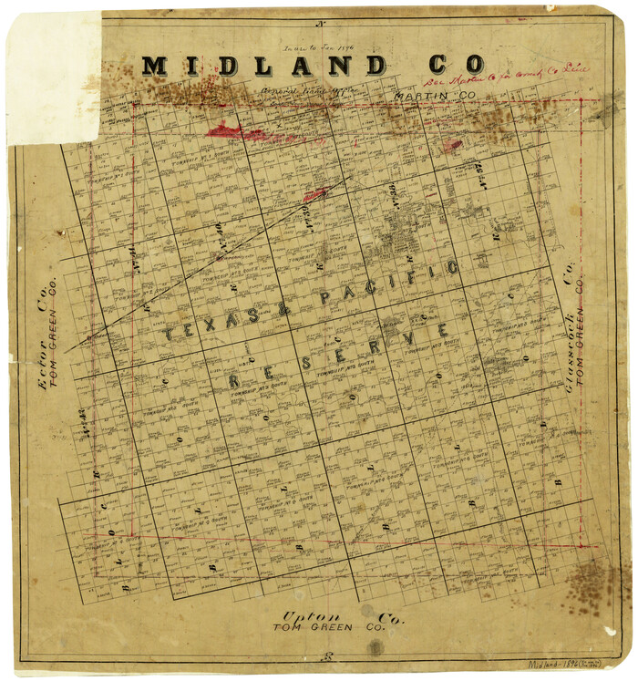
Midland County
Print $20.00
- Digital $50.00
Midland County
1896
Size 21.5 x 20.0 inches
Map/Doc 3877
Spence Addition Owned by L.N. Goldbeck and Herman Pressler - A Subdivision of Outlot 43, Division "O"

Print $20.00
- Digital $50.00
Spence Addition Owned by L.N. Goldbeck and Herman Pressler - A Subdivision of Outlot 43, Division "O"
1913
Size 15.4 x 12.8 inches
Map/Doc 632
Flight Mission No. DIX-10P, Frame 77, Aransas County

Print $20.00
- Digital $50.00
Flight Mission No. DIX-10P, Frame 77, Aransas County
1956
Size 18.6 x 22.3 inches
Map/Doc 83938
Cherokee County Working Sketch 9

Print $20.00
- Digital $50.00
Cherokee County Working Sketch 9
1957
Size 46.9 x 34.0 inches
Map/Doc 67964
[Surveys to the North and West of the Francis Blundell survey containing townsite]
![90884, [Surveys to the North and West of the Francis Blundell survey containing townsite], Twichell Survey Records](https://historictexasmaps.com/wmedia_w700/maps/90884-1.tif.jpg)
Print $20.00
- Digital $50.00
[Surveys to the North and West of the Francis Blundell survey containing townsite]
Size 26.3 x 19.8 inches
Map/Doc 90884
General Highway Map, Jones County, Texas

Print $20.00
General Highway Map, Jones County, Texas
1961
Size 18.2 x 24.5 inches
Map/Doc 79546
[Plat showing connecting lines for the purpose of locating 4.3 acres in Caldwell County]
![90220, [Plat showing connecting lines for the purpose of locating 4.3 acres in Caldwell County], Twichell Survey Records](https://historictexasmaps.com/wmedia_w700/maps/90220-1.tif.jpg)
Print $2.00
- Digital $50.00
[Plat showing connecting lines for the purpose of locating 4.3 acres in Caldwell County]
1923
Size 7.4 x 10.2 inches
Map/Doc 90220
Wood County Boundary File 1

Print $4.00
- Digital $50.00
Wood County Boundary File 1
Size 12.6 x 8.1 inches
Map/Doc 60154
Current Miscellaneous File 94

Print $3.00
- Digital $50.00
Current Miscellaneous File 94
1851
Size 11.2 x 17.1 inches
Map/Doc 74268
Nueces County Sketch File 14

Print $20.00
- Digital $50.00
Nueces County Sketch File 14
Size 18.3 x 20.8 inches
Map/Doc 42179
Sutton County Rolled Sketch 35

Print $20.00
- Digital $50.00
Sutton County Rolled Sketch 35
1886
Size 30.3 x 28.4 inches
Map/Doc 7879