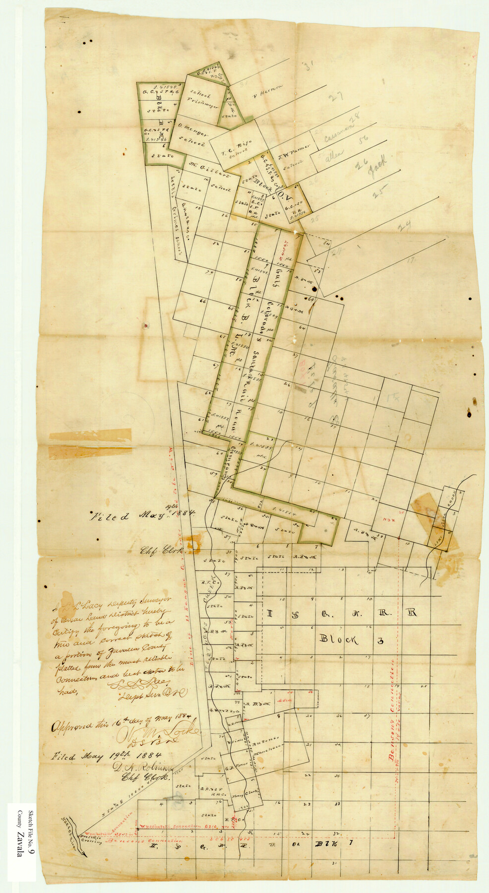
Zavala County Sketch File 9
[Sketch of surveys east of the large Aguirre surveys]
-
Map/Doc
12727
-
Collection
General Map Collection
-
Object Dates
5/16/1884 (Creation Date)
5/19/1884 (File Date)
-
People and Organizations
L.L. Lacy (Surveyor/Engineer)
-
Counties
Zavala Dimmit
-
Subjects
Surveying Sketch File
-
Height x Width
29.1 x 15.9 inches
73.9 x 40.4 cm
-
Medium
paper, manuscript
-
Features
Lomo [sic] Visza [sic] Creek
Tortugas Creek
Nueces River
Presidio Crossing
Part of: General Map Collection
Freestone County Sketch File 17

Print $4.00
- Digital $50.00
Freestone County Sketch File 17
1859
Size 6.3 x 8.1 inches
Map/Doc 23074
Reagan County Rolled Sketch 39

Print $20.00
- Digital $50.00
Reagan County Rolled Sketch 39
1966
Size 25.7 x 25.1 inches
Map/Doc 7450
Fractional Township No. 7 South Range No. 21 East of the Indian Meridian, Indian Territory

Print $20.00
- Digital $50.00
Fractional Township No. 7 South Range No. 21 East of the Indian Meridian, Indian Territory
1897
Size 19.2 x 24.2 inches
Map/Doc 75237
Coke County Sketch File 33

Print $20.00
- Digital $50.00
Coke County Sketch File 33
Size 22.0 x 26.6 inches
Map/Doc 11115
Jackson County Boundary File 3

Print $10.00
- Digital $50.00
Jackson County Boundary File 3
Size 10.9 x 8.7 inches
Map/Doc 55455
Map of the Fort Worth & Denver City Railway

Print $40.00
- Digital $50.00
Map of the Fort Worth & Denver City Railway
1887
Size 21.7 x 72.8 inches
Map/Doc 64479
Gonzales County Working Sketch 11
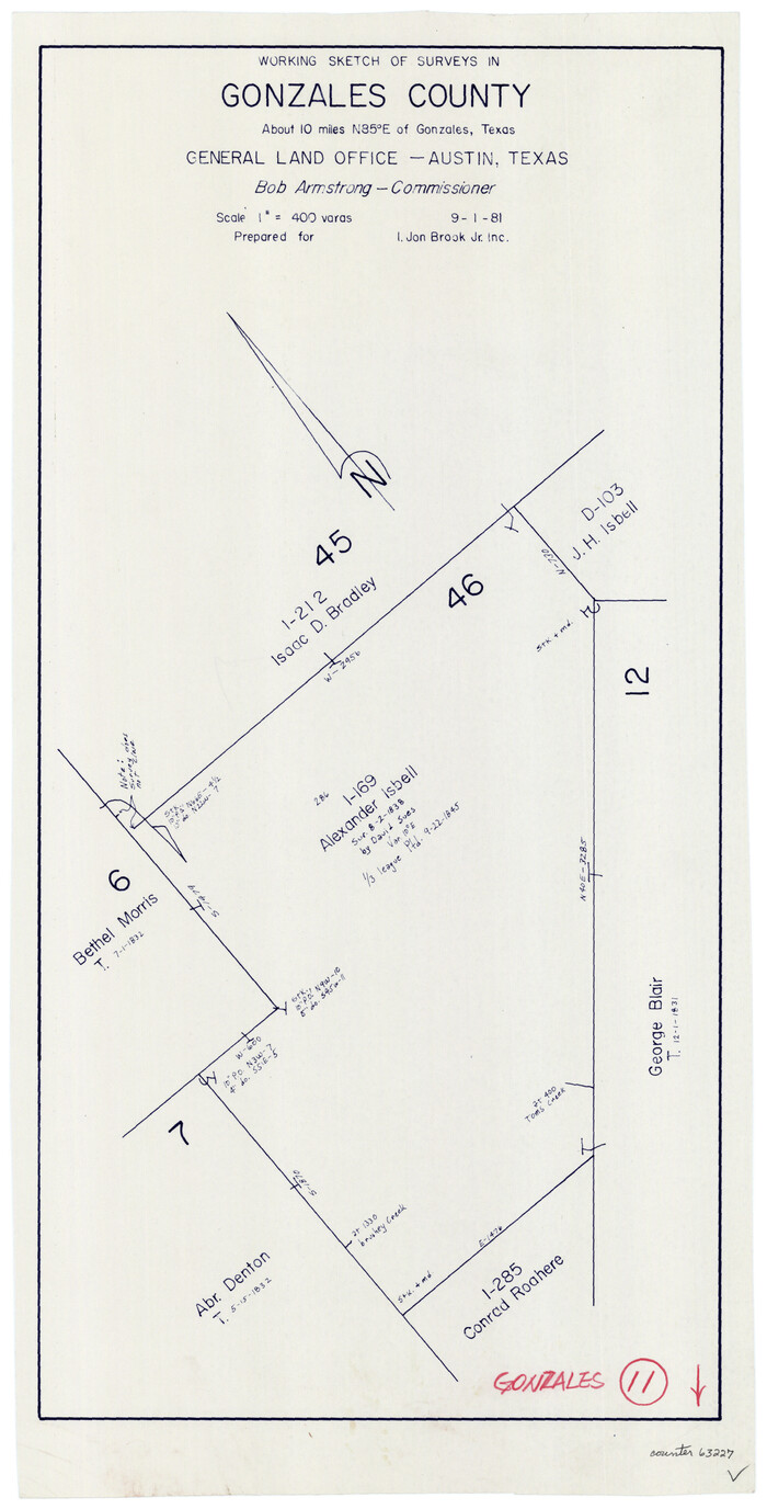
Print $20.00
- Digital $50.00
Gonzales County Working Sketch 11
1981
Size 22.2 x 11.3 inches
Map/Doc 63227
Cameron County NRC Article 33.136 Location Key Sheet

Print $20.00
- Digital $50.00
Cameron County NRC Article 33.136 Location Key Sheet
1983
Size 27.0 x 22.0 inches
Map/Doc 77013
Sketch Showing Surveys Made for W. R. Cartledge

Print $20.00
- Digital $50.00
Sketch Showing Surveys Made for W. R. Cartledge
1945
Size 17.3 x 13.8 inches
Map/Doc 60296
[Sketch for Mineral Application 26501 - Sabine River, T. A. Oldhausen]
![2846, [Sketch for Mineral Application 26501 - Sabine River, T. A. Oldhausen], General Map Collection](https://historictexasmaps.com/wmedia_w700/maps/2846.tif.jpg)
Print $20.00
- Digital $50.00
[Sketch for Mineral Application 26501 - Sabine River, T. A. Oldhausen]
1931
Size 24.4 x 37.0 inches
Map/Doc 2846
Llano County Working Sketch 11

Print $40.00
- Digital $50.00
Llano County Working Sketch 11
1983
Size 38.0 x 48.2 inches
Map/Doc 70629
Ochiltree County Sketch File 12

Print $24.00
- Digital $50.00
Ochiltree County Sketch File 12
1990
Size 11.2 x 8.5 inches
Map/Doc 33201
You may also like
Map of Liberty County

Print $20.00
- Digital $50.00
Map of Liberty County
Size 27.6 x 26.2 inches
Map/Doc 91079
Stonewall County Working Sketch 14

Print $20.00
- Digital $50.00
Stonewall County Working Sketch 14
1951
Size 22.2 x 37.1 inches
Map/Doc 62321

Map of Ellis County

Print $40.00
- Digital $50.00
Map of Ellis County
1889
Size 39.2 x 48.1 inches
Map/Doc 4712
Orange County Working Sketch 7

Print $20.00
- Digital $50.00
Orange County Working Sketch 7
1922
Size 21.9 x 31.9 inches
Map/Doc 71339
Washington County Working Sketch 3

Print $20.00
- Digital $50.00
Washington County Working Sketch 3
1992
Size 31.5 x 42.7 inches
Map/Doc 72364
Taylor County Sketch File 19

Print $10.00
- Digital $50.00
Taylor County Sketch File 19
1945
Size 14.2 x 8.8 inches
Map/Doc 37816
Pecos County Rolled Sketch 26

Print $20.00
- Digital $50.00
Pecos County Rolled Sketch 26
1899
Size 19.9 x 23.6 inches
Map/Doc 7211
Liberty County Working Sketch 46

Print $20.00
- Digital $50.00
Liberty County Working Sketch 46
1953
Size 18.6 x 37.6 inches
Map/Doc 70505
Dickens County Working Sketch 3

Print $20.00
- Digital $50.00
Dickens County Working Sketch 3
Size 17.5 x 15.3 inches
Map/Doc 68650
Carte Reduite du Golphe du Mexique et des isles de l'Amerique dressée au depost des cartes et plans de la Marine pour le service des vaisseaux du Roy

Print $20.00
- Digital $50.00
Carte Reduite du Golphe du Mexique et des isles de l'Amerique dressée au depost des cartes et plans de la Marine pour le service des vaisseaux du Roy
1774
Size 25.5 x 32.9 inches
Map/Doc 94097
Baylor County Working Sketch 2

Print $20.00
- Digital $50.00
Baylor County Working Sketch 2
1919
Size 22.4 x 24.1 inches
Map/Doc 67287