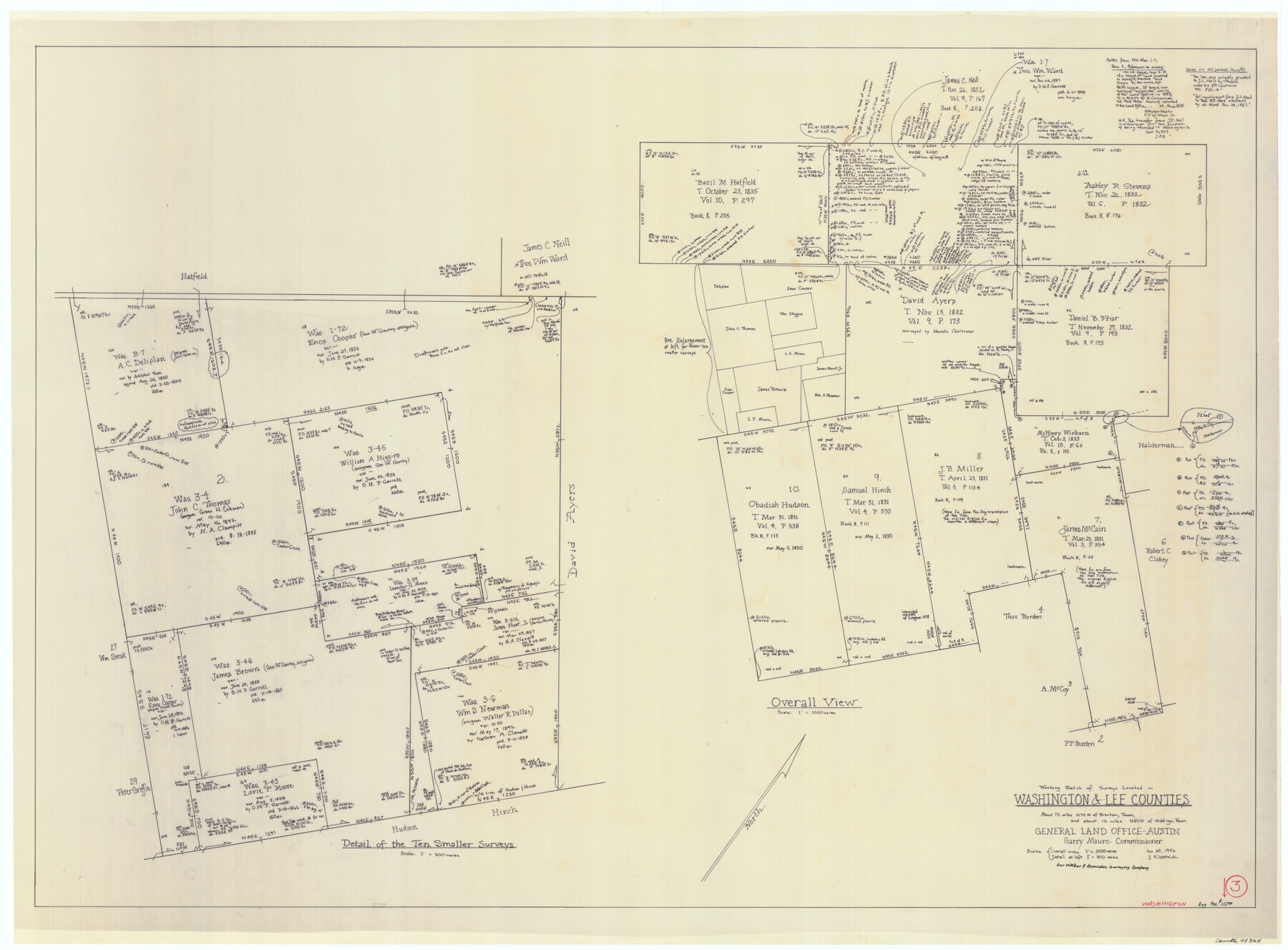
Washington County Working Sketch 3
-
Map/Doc
72364
-
Collection
General Map Collection
-
Object Dates
1/20/1992 (Creation Date)
-
People and Organizations
Joan Kilpatrick (Draftsman)
-
Counties
Washington Lee
-
Subjects
Surveying Working Sketch
-
Height x Width
31.5 x 42.7 inches
80.0 x 108.5 cm
-
Scale
1" = 1000 varas
Part of: General Map Collection
Routes to HemisFair '68 : World's Fair, San Antonio, Texas, April 6 through Oct. 6, 1968 [Verso]
![94169, Hemisfair Gulf Tourgide Map [Verso], General Map Collection](https://historictexasmaps.com/wmedia_w700/maps/94169.tif.jpg)
Routes to HemisFair '68 : World's Fair, San Antonio, Texas, April 6 through Oct. 6, 1968 [Verso]
Size 18.3 x 24.3 inches
Map/Doc 94169
El Paso County Rolled Sketch 56

Print $20.00
- Digital $50.00
El Paso County Rolled Sketch 56
1982
Size 33.5 x 36.6 inches
Map/Doc 8878
Hardin County Sketch File 15

Print $6.00
- Digital $50.00
Hardin County Sketch File 15
Size 9.0 x 4.9 inches
Map/Doc 25122
Tom Green County Working Sketch 13

Print $20.00
- Digital $50.00
Tom Green County Working Sketch 13
1981
Size 34.3 x 26.4 inches
Map/Doc 69382
Carta de las provincias de Tejas Nuevo Santander, Nuevo Reino de Leon y Nueva Estremadura

Print $20.00
- Digital $50.00
Carta de las provincias de Tejas Nuevo Santander, Nuevo Reino de Leon y Nueva Estremadura
1773
Size 21.5 x 26.6 inches
Map/Doc 3031
Sutton County Sketch File 14

Print $20.00
- Digital $50.00
Sutton County Sketch File 14
1924
Size 17.8 x 20.0 inches
Map/Doc 12380
Roberts County Sketch File 10

Print $32.00
- Digital $50.00
Roberts County Sketch File 10
2016
Size 11.0 x 8.5 inches
Map/Doc 94070
Montague County Working Sketch Graphic Index

Print $20.00
- Digital $50.00
Montague County Working Sketch Graphic Index
1924
Size 45.3 x 33.2 inches
Map/Doc 76645

Clay County Boundary File 5

Print $6.00
- Digital $50.00
Clay County Boundary File 5
Size 11.1 x 8.5 inches
Map/Doc 51373
City of Aransas Pass and Chart of Aransas Bay and Corpus Christi Bay, Texas

Print $20.00
- Digital $50.00
City of Aransas Pass and Chart of Aransas Bay and Corpus Christi Bay, Texas
1905
Size 28.4 x 21.4 inches
Map/Doc 97265
Goliad County Sketch File 30

Print $40.00
- Digital $50.00
Goliad County Sketch File 30
Size 13.0 x 15.0 inches
Map/Doc 24327
You may also like
Edwards County Sketch File 27

Print $6.00
- Digital $50.00
Edwards County Sketch File 27
1913
Size 10.5 x 16.5 inches
Map/Doc 21755
Mills County Boundary File 3a

Print $48.00
- Digital $50.00
Mills County Boundary File 3a
Size 14.2 x 8.8 inches
Map/Doc 57287
Presidio County Rolled Sketch 95

Print $20.00
- Digital $50.00
Presidio County Rolled Sketch 95
1949
Size 45.4 x 37.5 inches
Map/Doc 9781
Moore County Working Sketch 6

Print $20.00
- Digital $50.00
Moore County Working Sketch 6
1921
Size 16.0 x 14.5 inches
Map/Doc 71188

Map of Pecos County, Texas

Print $20.00
- Digital $50.00
Map of Pecos County, Texas
Size 18.9 x 22.8 inches
Map/Doc 91573
Map of the Middle States engraved to illustrate Mitchell's new intermediate geography

Print $20.00
- Digital $50.00
Map of the Middle States engraved to illustrate Mitchell's new intermediate geography
1885
Size 12.2 x 9.0 inches
Map/Doc 93516
Jackson County Rolled Sketch 8

Print $20.00
- Digital $50.00
Jackson County Rolled Sketch 8
1938
Size 28.6 x 28.1 inches
Map/Doc 6343
Grayson County Working Sketch Graphic Index

Print $20.00
- Digital $50.00
Grayson County Working Sketch Graphic Index
1935
Size 44.4 x 41.0 inches
Map/Doc 76558
Harris County Aerial Photograph Index Sheet 9

Print $20.00
- Digital $50.00
Harris County Aerial Photograph Index Sheet 9
1953
Size 22.1 x 16.6 inches
Map/Doc 83703
Maps of Gulf Intracoastal Waterway, Texas - Sabine River to the Rio Grande and connecting waterways including ship channels

Print $20.00
- Digital $50.00
Maps of Gulf Intracoastal Waterway, Texas - Sabine River to the Rio Grande and connecting waterways including ship channels
1966
Size 14.5 x 22.2 inches
Map/Doc 61920
Colorado County Sketch File 20

Print $6.00
- Digital $50.00
Colorado County Sketch File 20
Size 6.0 x 7.6 inches
Map/Doc 18954