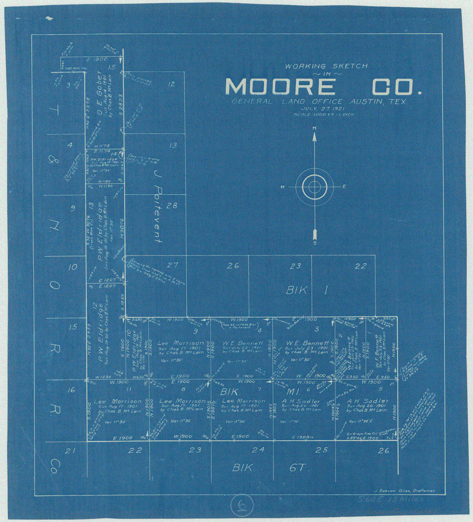
Moore County Working Sketch 6
-
Map/Doc
71188
-
Collection
General Map Collection
-
Object Dates
7/27/1921 (Creation Date)
-
People and Organizations
J. Bascom Giles (Draftsman)
-
Counties
Moore
-
Subjects
Surveying Working Sketch
-
Height x Width
16.0 x 14.5 inches
40.6 x 36.8 cm
-
Scale
1" = 1000 varas
Part of: General Map Collection
Dimmit County Sketch File 35

Print $6.00
- Digital $50.00
Dimmit County Sketch File 35
1885
Size 6.5 x 8.5 inches
Map/Doc 21155
Galveston County NRC Article 33.136 Sketch 7

Print $20.00
- Digital $50.00
Galveston County NRC Article 33.136 Sketch 7
2001
Size 23.7 x 37.2 inches
Map/Doc 61589
Concho County Sketch File 48

Print $4.00
- Digital $50.00
Concho County Sketch File 48
1916
Size 11.3 x 8.9 inches
Map/Doc 19215
Live Oak County Working Sketch 20

Print $20.00
- Digital $50.00
Live Oak County Working Sketch 20
1962
Size 29.7 x 35.7 inches
Map/Doc 70605
Terrell County Sketch File 23

Print $10.00
- Digital $50.00
Terrell County Sketch File 23
1932
Size 14.3 x 8.9 inches
Map/Doc 37954
Live Oak County Sketch File 33

Print $4.00
- Digital $50.00
Live Oak County Sketch File 33
1874
Size 11.9 x 7.6 inches
Map/Doc 30333
Map of Hill County

Print $40.00
- Digital $50.00
Map of Hill County
1884
Size 80.1 x 68.0 inches
Map/Doc 82049
Val Verde County Working Sketch 69

Print $20.00
- Digital $50.00
Val Verde County Working Sketch 69
1965
Size 35.6 x 37.3 inches
Map/Doc 72204
Zapata County Sketch File 10

Print $40.00
- Digital $50.00
Zapata County Sketch File 10
1917
Size 51.0 x 32.6 inches
Map/Doc 10440
Coke County Sketch File AB

Print $12.00
- Digital $50.00
Coke County Sketch File AB
1884
Size 14.1 x 8.7 inches
Map/Doc 18608
[Folder for] Nautical Chart 11305: Texas Intracoastal Waterway, Laguna Madre, Rincon de San Jose to Chubby Island
![75913, [Folder for] Nautical Chart 11305: Texas Intracoastal Waterway, Laguna Madre, Rincon de San Jose to Chubby Island, General Map Collection](https://historictexasmaps.com/wmedia_w700/maps/75913-1.tif.jpg)
Print $20.00
- Digital $50.00
[Folder for] Nautical Chart 11305: Texas Intracoastal Waterway, Laguna Madre, Rincon de San Jose to Chubby Island
1976
Size 16.0 x 19.0 inches
Map/Doc 75913
Dallam County Working Sketch 2

Print $20.00
- Digital $50.00
Dallam County Working Sketch 2
1906
Size 38.5 x 24.1 inches
Map/Doc 68587
You may also like
La Salle County Sketch File 12

Print $15.00
- Digital $50.00
La Salle County Sketch File 12
1877
Size 10.0 x 8.1 inches
Map/Doc 29470
United States - Gulf Coast Texas - Southern part of Laguna Madre

Print $20.00
- Digital $50.00
United States - Gulf Coast Texas - Southern part of Laguna Madre
1941
Size 26.7 x 18.5 inches
Map/Doc 72942
[Surveys near Keechi Creek and the Trinity River]
![47, [Surveys near Keechi Creek and the Trinity River], General Map Collection](https://historictexasmaps.com/wmedia_w700/maps/47.tif.jpg)
Print $2.00
- Digital $50.00
[Surveys near Keechi Creek and the Trinity River]
1841
Size 8.6 x 8.2 inches
Map/Doc 47
Trinity County Sketch File 28

Print $22.00
- Digital $50.00
Trinity County Sketch File 28
Size 7.0 x 19.7 inches
Map/Doc 38564
Harris County Working Sketch 108

Print $20.00
- Digital $50.00
Harris County Working Sketch 108
1981
Size 20.6 x 20.5 inches
Map/Doc 66000
Val Verde County Sketch File XXX6

Print $6.00
- Digital $50.00
Val Verde County Sketch File XXX6
Size 17.0 x 9.9 inches
Map/Doc 39102
Howard County Sketch File 14

Print $8.00
- Digital $50.00
Howard County Sketch File 14
1940
Size 11.3 x 8.8 inches
Map/Doc 26871
Coleman County Sketch File 24a

Print $6.00
- Digital $50.00
Coleman County Sketch File 24a
1872
Size 10.2 x 15.9 inches
Map/Doc 18708
Andrews County Rolled Sketch 41

Print $20.00
- Digital $50.00
Andrews County Rolled Sketch 41
Size 18.0 x 24.0 inches
Map/Doc 77181
Galveston to Rio Grande

Print $20.00
- Digital $50.00
Galveston to Rio Grande
1946
Size 44.6 x 36.6 inches
Map/Doc 69952
Gaines County Rolled Sketch 20

Print $20.00
- Digital $50.00
Gaines County Rolled Sketch 20
1955
Size 30.1 x 37.2 inches
Map/Doc 5936
Flight Mission No. BRA-7M, Frame 150, Jefferson County

Print $20.00
- Digital $50.00
Flight Mission No. BRA-7M, Frame 150, Jefferson County
1953
Size 18.7 x 22.4 inches
Map/Doc 85544