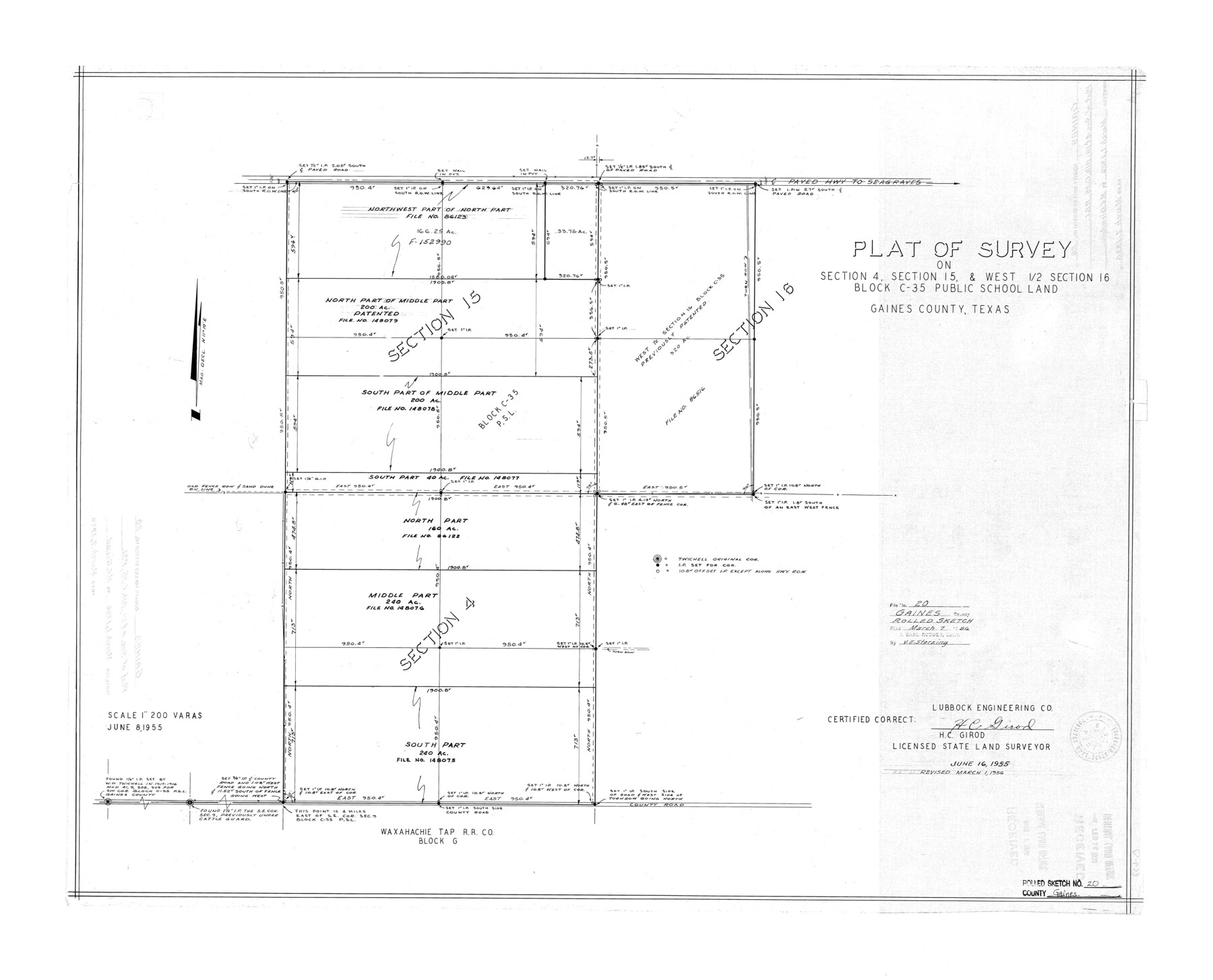
Gaines County Rolled Sketch 20
Plat of survey on section 4, section 15, & west 1/2 section 16, Block C-35, Public School Land
-
Map/Doc
5936
-
Collection
General Map Collection
-
Object Dates
1956/3/1 (Revision Date)
1956/3/7 (File Date)
1955/6/16 (Creation Date)
-
People and Organizations
H.C. Girod (Surveyor/Engineer)
-
Counties
Gaines
-
Subjects
Surveying Rolled Sketch
-
Height x Width
30.1 x 37.2 inches
76.5 x 94.5 cm
-
Scale
1" = 200 varas
Part of: General Map Collection
Flight Mission No. CLL-3N, Frame 35, Willacy County

Print $20.00
- Digital $50.00
Flight Mission No. CLL-3N, Frame 35, Willacy County
1954
Size 18.3 x 22.1 inches
Map/Doc 87093
Liberty County Working Sketch 61

Print $20.00
- Digital $50.00
Liberty County Working Sketch 61
1969
Size 43.3 x 32.0 inches
Map/Doc 70521

Coryell County Working Sketch 21

Print $20.00
- Digital $50.00
Coryell County Working Sketch 21
1973
Size 37.0 x 37.8 inches
Map/Doc 68228
Crockett County Rolled Sketch 88M

Print $20.00
- Digital $50.00
Crockett County Rolled Sketch 88M
1964
Size 25.2 x 34.2 inches
Map/Doc 5629
Zavala County Sketch File 2

Print $22.00
- Digital $50.00
Zavala County Sketch File 2
Size 13.2 x 14.4 inches
Map/Doc 41261
Duval County Working Sketch 49

Print $40.00
- Digital $50.00
Duval County Working Sketch 49
1981
Size 37.0 x 81.3 inches
Map/Doc 68773
Terry County Working Sketch Graphic Index

Print $20.00
- Digital $50.00
Terry County Working Sketch Graphic Index
1970
Size 41.2 x 33.8 inches
Map/Doc 76712
El Paso County Rolled Sketch RJ

Print $40.00
- Digital $50.00
El Paso County Rolled Sketch RJ
1919
Size 56.7 x 27.2 inches
Map/Doc 8865
J No. 5 - Reconnaissance of San Pedro Harbor, California

Print $20.00
- Digital $50.00
J No. 5 - Reconnaissance of San Pedro Harbor, California
1852
Size 12.3 x 15.5 inches
Map/Doc 97232
FT. W. & R. G. Ry. Right of Way Map, Whiteland to Lightner, Concho County, Texas

Print $40.00
- Digital $50.00
FT. W. & R. G. Ry. Right of Way Map, Whiteland to Lightner, Concho County, Texas
1918
Size 39.6 x 121.3 inches
Map/Doc 61412
Menard County Sketch File 9

Print $4.00
- Digital $50.00
Menard County Sketch File 9
Size 10.7 x 8.2 inches
Map/Doc 31494
You may also like
Jefferson County Sketch File 2

Print $50.00
- Digital $50.00
Jefferson County Sketch File 2
Size 11.2 x 8.8 inches
Map/Doc 28090
[S.E. corner of Sec. 48, Blk. 35 T5N to N.E. corner of Sec. 1, Blk. 35 T5N]
![89826, [S.E. corner of Sec. 48, Blk. 35 T5N to N.E. corner of Sec. 1, Blk. 35 T5N], Twichell Survey Records](https://historictexasmaps.com/wmedia_w700/maps/89826-1.tif.jpg)
Print $40.00
- Digital $50.00
[S.E. corner of Sec. 48, Blk. 35 T5N to N.E. corner of Sec. 1, Blk. 35 T5N]
1907
Size 7.2 x 72.9 inches
Map/Doc 89826
San Bernard River, Texas showing possible connection with Brazos River and part of possible connection with Matagorda Bay for a Light Draft Navigation

Print $40.00
- Digital $50.00
San Bernard River, Texas showing possible connection with Brazos River and part of possible connection with Matagorda Bay for a Light Draft Navigation
Size 17.2 x 56.1 inches
Map/Doc 96561
Baylor County Sketch File 11C

Print $20.00
- Digital $50.00
Baylor County Sketch File 11C
1892
Map/Doc 88491
Ward County Working Sketch 3

Print $20.00
- Digital $50.00
Ward County Working Sketch 3
1935
Size 24.1 x 27.1 inches
Map/Doc 72309
[Sketch for Mineral Application 27670 - Strip between Simon Sanchez leagues and Trinity River]
![2865, [Sketch for Mineral Application 27670 - Strip between Simon Sanchez leagues and Trinity River], General Map Collection](https://historictexasmaps.com/wmedia_w700/maps/2865-1.tif.jpg)
Print $40.00
- Digital $50.00
[Sketch for Mineral Application 27670 - Strip between Simon Sanchez leagues and Trinity River]
1934
Size 17.3 x 50.5 inches
Map/Doc 2865
Bandera County Sketch File 21

Print $4.00
- Digital $50.00
Bandera County Sketch File 21
Size 12.7 x 8.1 inches
Map/Doc 14010
Cochran County Sketch File 6

Print $10.00
- Digital $50.00
Cochran County Sketch File 6
1938
Size 11.2 x 8.6 inches
Map/Doc 18545
Gregg County Sketch File 14

Print $6.00
- Digital $50.00
Gregg County Sketch File 14
1946
Size 14.3 x 8.8 inches
Map/Doc 24613
[Surveys in the Bexar District along the Balcones, Cibolo and Leon Creeks]
![63, [Surveys in the Bexar District along the Balcones, Cibolo and Leon Creeks], General Map Collection](https://historictexasmaps.com/wmedia_w700/maps/63.tif.jpg)
Print $3.00
- Digital $50.00
[Surveys in the Bexar District along the Balcones, Cibolo and Leon Creeks]
1842
Size 10.6 x 12.4 inches
Map/Doc 63
Map of the City of Austin Texas

Map of the City of Austin Texas
1933
Size 22.6 x 17.6 inches
Map/Doc 1685
[Sketch for Mineral Application 16700 - Pecos River Bed]
![2811, [Sketch for Mineral Application 16700 - Pecos River Bed], General Map Collection](https://historictexasmaps.com/wmedia_w700/maps/2811.tif.jpg)
Print $20.00
- Digital $50.00
[Sketch for Mineral Application 16700 - Pecos River Bed]
1927
Size 20.6 x 28.6 inches
Map/Doc 2811