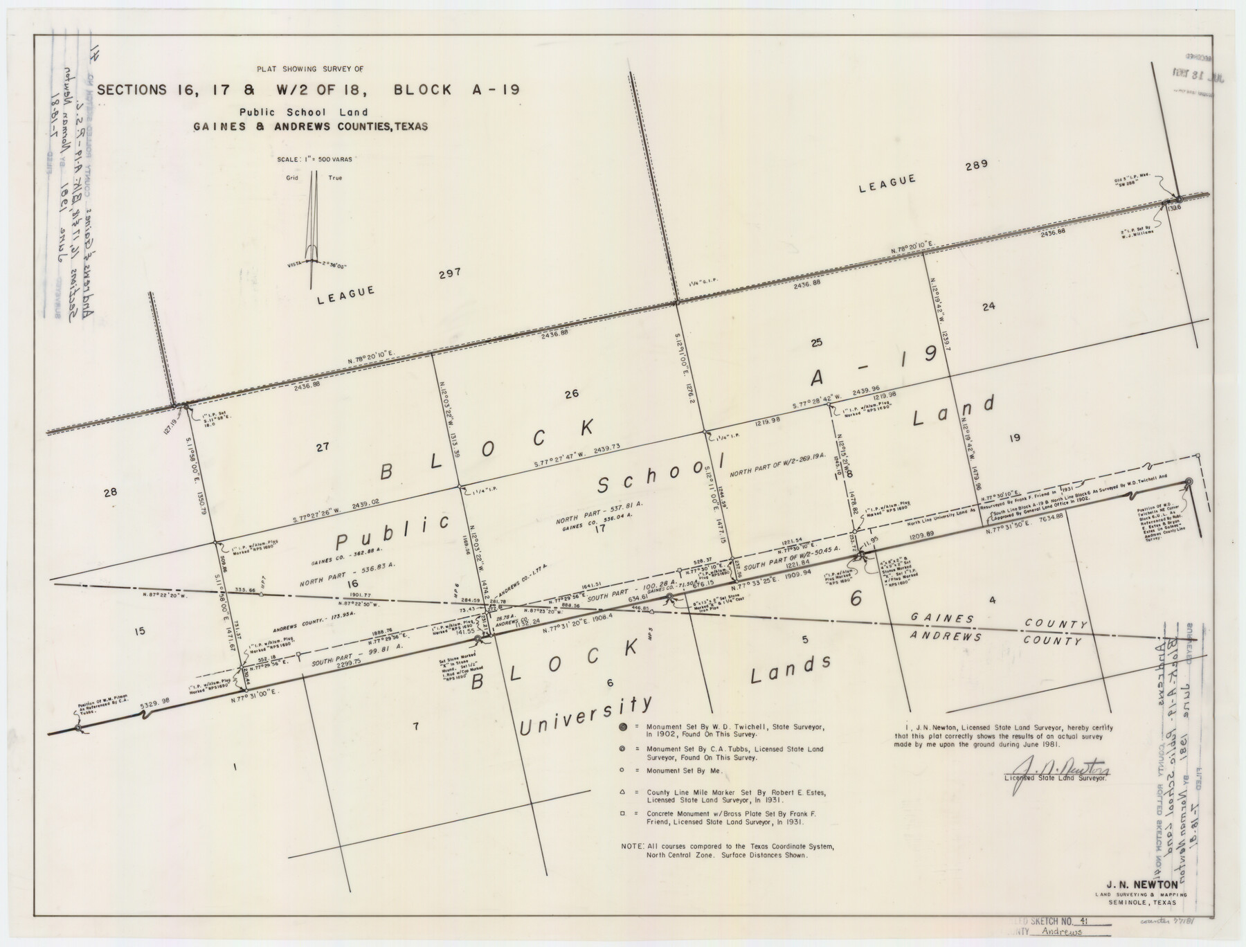
Andrews County Rolled Sketch 41
Plat showing survey of sections 16, 17, & W/2 of 18, Block A-19 PSL
-
Map/Doc
77181
-
Collection
General Map Collection
-
Object Dates
1981 (Survey Date)
1981/7/18 (File Date)
-
People and Organizations
J.N. Newton (Surveyor/Engineer)
-
Counties
Andrews Gaines
-
Subjects
Surveying Rolled Sketch
-
Height x Width
18.0 x 24.0 inches
45.7 x 61.0 cm
-
Medium
mylar, print
-
Scale
1" = 500 varas
Part of: General Map Collection
Flight Mission No. CRK-3P, Frame 63, Refugio County

Print $20.00
- Digital $50.00
Flight Mission No. CRK-3P, Frame 63, Refugio County
1956
Size 18.5 x 22.4 inches
Map/Doc 86905
La Salle County Sketch File 18

Print $4.00
- Digital $50.00
La Salle County Sketch File 18
1885
Size 8.5 x 15.5 inches
Map/Doc 29507
Eastland County Working Sketch 65

Print $20.00
- Digital $50.00
Eastland County Working Sketch 65
1986
Size 37.4 x 16.5 inches
Map/Doc 88892
Shelby County Rolled Sketch 13

Print $20.00
- Digital $50.00
Shelby County Rolled Sketch 13
1945
Size 24.5 x 27.8 inches
Map/Doc 7781
Liberty County Sketch File 6a

Print $2.00
- Digital $50.00
Liberty County Sketch File 6a
1859
Size 7.5 x 8.4 inches
Map/Doc 29896
Tourist Map of San Antonio showing points of interest, places of amusements, main thoroughfares and highways in and out of city and where they go

Print $20.00
- Digital $50.00
Tourist Map of San Antonio showing points of interest, places of amusements, main thoroughfares and highways in and out of city and where they go
Size 22.2 x 15.3 inches
Map/Doc 95956
Uvalde County Working Sketch 27

Print $20.00
- Digital $50.00
Uvalde County Working Sketch 27
1957
Size 24.4 x 25.7 inches
Map/Doc 72097
Flight Mission No. DQN-7K, Frame 37, Calhoun County

Print $20.00
- Digital $50.00
Flight Mission No. DQN-7K, Frame 37, Calhoun County
1953
Size 18.4 x 22.1 inches
Map/Doc 84475
Trinity County Sketch File 15

Print $6.00
- Digital $50.00
Trinity County Sketch File 15
Size 14.5 x 10.4 inches
Map/Doc 38542
Intracoastal Waterway in Texas - Corpus Christi to Point Isabel including Arroyo Colorado to Mo. Pac. R.R. Bridge Near Harlingen

Print $20.00
- Digital $50.00
Intracoastal Waterway in Texas - Corpus Christi to Point Isabel including Arroyo Colorado to Mo. Pac. R.R. Bridge Near Harlingen
1933
Size 27.9 x 40.9 inches
Map/Doc 61865
Erath County Sketch File 28

Print $40.00
- Digital $50.00
Erath County Sketch File 28
1895
Size 16.5 x 12.0 inches
Map/Doc 22309
Kleberg County Boundary File 2a

Print $40.00
- Digital $50.00
Kleberg County Boundary File 2a
Size 15.4 x 58.3 inches
Map/Doc 64977
You may also like
Sutton County Working Sketch 31

Print $20.00
- Digital $50.00
Sutton County Working Sketch 31
1929
Size 19.2 x 21.8 inches
Map/Doc 62374
[Sketch showing the Northwest part of Hale County and the Northeast part of Lamb County]
![93204, [Sketch showing the Northwest part of Hale County and the Northeast part of Lamb County], Twichell Survey Records](https://historictexasmaps.com/wmedia_w700/maps/93204-1.tif.jpg)
Print $40.00
- Digital $50.00
[Sketch showing the Northwest part of Hale County and the Northeast part of Lamb County]
Size 55.1 x 57.3 inches
Map/Doc 93204
Cochran County

Print $20.00
- Digital $50.00
Cochran County
1899
Size 40.9 x 32.6 inches
Map/Doc 4744
Morris County Working Sketch 6

Print $20.00
- Digital $50.00
Morris County Working Sketch 6
1985
Size 35.8 x 36.7 inches
Map/Doc 71205
Hill County Sketch File 27

Print $4.00
- Digital $50.00
Hill County Sketch File 27
1873
Size 10.4 x 8.2 inches
Map/Doc 26528
Wharton County Rolled Sketch 11

Print $20.00
- Digital $50.00
Wharton County Rolled Sketch 11
Size 27.3 x 37.2 inches
Map/Doc 8235
[T. & N. O. Railroad Company, Block 2T]
![91516, [T. & N. O. Railroad Company, Block 2T], Twichell Survey Records](https://historictexasmaps.com/wmedia_w700/maps/91516-1.tif.jpg)
Print $20.00
- Digital $50.00
[T. & N. O. Railroad Company, Block 2T]
Size 30.6 x 9.5 inches
Map/Doc 91516

Sabine County Working Sketch 11

Print $20.00
- Digital $50.00
Sabine County Working Sketch 11
1931
Size 30.9 x 34.0 inches
Map/Doc 63682
Crane County Sketch File 25

Print $4.00
- Digital $50.00
Crane County Sketch File 25
1935
Size 14.3 x 8.7 inches
Map/Doc 19596
Flight Mission No. DCL-6C, Frame 67, Kenedy County

Print $20.00
- Digital $50.00
Flight Mission No. DCL-6C, Frame 67, Kenedy County
1943
Size 18.6 x 22.2 inches
Map/Doc 85909
University Lands, Block 35, Crane & Ector Counties

Print $20.00
- Digital $50.00
University Lands, Block 35, Crane & Ector Counties
1935
Size 39.9 x 45.5 inches
Map/Doc 2406