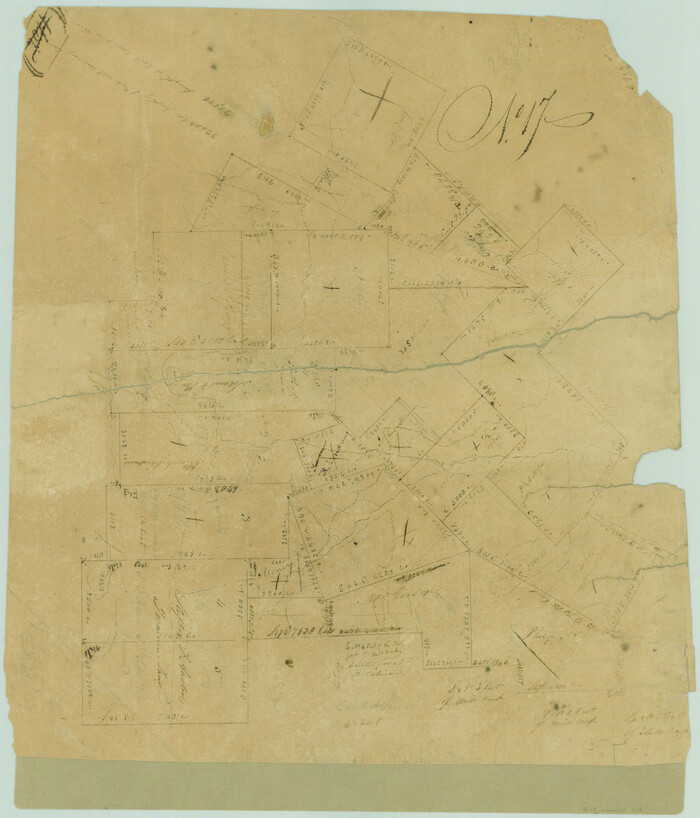
Austin County Sketch File 10

Print $40.00
- Digital $50.00
Austin County Sketch File 10
1895
Size: 25.5 x 21.0 inches
10875
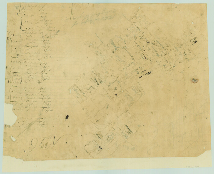
Washington County Sketch File 6

Print $20.00
- Digital $50.00
Washington County Sketch File 6
1901
Size: 24.7 x 26.0 inches
12602
Burleson County Sketch File 9

Print $12.00
- Digital $50.00
Burleson County Sketch File 9
1929
Size: 14.2 x 8.1 inches
16657
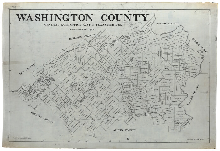
Washington County

Print $20.00
- Digital $50.00
Washington County
1920
Size: 32.5 x 47.2 inches
16918
Washington County
Print $40.00
- Digital $50.00
Washington County
1920
Size: 33.5 x 48.8 inches
1900
[Surveys in Austin's Colony along Hickory Creek, Hog Creek, and the Yegua River]
Print $20.00
- Digital $50.00
[Surveys in Austin's Colony along Hickory Creek, Hog Creek, and the Yegua River]
1831
Size: 19.4 x 23.9 inches
195
[Surveys in Austin's Colony along New Year's Creek]
Print $20.00
- Digital $50.00
[Surveys in Austin's Colony along New Year's Creek]
1828
Size: 12.9 x 15.5 inches
204
Surveys in Austin's Colony along the east fork of Mill Creek

Print $20.00
- Digital $50.00
Surveys in Austin's Colony along the east fork of Mill Creek
1830
Size: 23.7 x 12.6 inches
208
[Surveys in Austin's Colony along New Year's Creek and the Navidad River]
Print $20.00
- Digital $50.00
[Surveys in Austin's Colony along New Year's Creek and the Navidad River]
Size: 20.2 x 15.6 inches
212
[Surveys in Austin's Colony along New Year's Creek and near the Brazos River]
Print $20.00
- Digital $50.00
[Surveys in Austin's Colony along New Year's Creek and near the Brazos River]
1821
Size: 17.4 x 14.9 inches
218
El Paso County Sketch File 22a

Print $52.00
- Digital $50.00
El Paso County Sketch File 22a
1888
Size: 14.2 x 8.7 inches
22042
Washington County Sketch File 2

Print $4.00
- Digital $50.00
Washington County Sketch File 2
1855
Size: 8.3 x 12.5 inches
39646
Washington County Sketch File 3

Print $4.00
- Digital $50.00
Washington County Sketch File 3
1860
Size: 8.1 x 9.2 inches
39648
Washington County Sketch File 4

Print $4.00
- Digital $50.00
Washington County Sketch File 4
1863
Size: 12.8 x 7.8 inches
39650
Washington County Sketch File 5

Print $4.00
- Digital $50.00
Washington County Sketch File 5
Size: 8.0 x 7.0 inches
39652
Washington County Sketch File 7

Print $4.00
- Digital $50.00
Washington County Sketch File 7
1873
Size: 12.2 x 7.6 inches
39654
Map of Washington County

Print $20.00
- Digital $50.00
Map of Washington County
1841
Size: 28.5 x 29.0 inches
4122
Washington County

Print $20.00
- Digital $50.00
Washington County
1871
Size: 11.9 x 27.7 inches
4123
Washington County Texas

Print $20.00
- Digital $50.00
Washington County Texas
1879
Size: 13.2 x 21.3 inches
4124
Map of Washington District

Print $20.00
- Digital $50.00
Map of Washington District
1847
Size: 17.6 x 26.8 inches
4125
Map of Washington County

Print $20.00
- Digital $50.00
Map of Washington County
1841
Size: 18.9 x 27.1 inches
4126
Washington County

Print $20.00
- Digital $50.00
Washington County
1863
Size: 15.9 x 27.2 inches
4127
Washington County

Print $40.00
- Digital $50.00
Washington County
1920
Size: 33.4 x 48.6 inches
63112
Map of the Western Branch of Houston & Tex. Central R.R. for the Distance from Brenham to Austin

Print $40.00
- Digital $50.00
Map of the Western Branch of Houston & Tex. Central R.R. for the Distance from Brenham to Austin
1872
Size: 32.6 x 97.3 inches
64578
Brazos River, Howth Sheet

Print $6.00
- Digital $50.00
Brazos River, Howth Sheet
1936
Size: 30.5 x 30.9 inches
65276
Brazos River, Washington Sheet

Print $6.00
- Digital $50.00
Brazos River, Washington Sheet
1936
Size: 30.4 x 24.7 inches
65277
Brazos River, Millican Sheet

Print $6.00
- Digital $50.00
Brazos River, Millican Sheet
1936
Size: 30.1 x 31.6 inches
65278
Brazos River, Sandpit Special Sheet

Print $6.00
- Digital $50.00
Brazos River, Sandpit Special Sheet
1936
Size: 33.8 x 24.7 inches
65279
Brazos River, Widths of Floodways/Brazos and Navasota Rivers

Print $20.00
- Digital $50.00
Brazos River, Widths of Floodways/Brazos and Navasota Rivers
1921
Size: 38.1 x 24.5 inches
65292
[Surveys in Austin's Colony along the Yegua River and Cedar Creek]
Print $20.00
- Digital $50.00
[Surveys in Austin's Colony along the Yegua River and Cedar Creek]
1835
Size: 15.7 x 19.3 inches
67
Austin County Sketch File 10
Print $40.00
- Digital $50.00
Austin County Sketch File 10
1895
-
Size
25.5 x 21.0 inches
-
Map/Doc
10875
-
Creation Date
1895
Washington County Sketch File 6
Print $20.00
- Digital $50.00
Washington County Sketch File 6
1901
-
Size
24.7 x 26.0 inches
-
Map/Doc
12602
-
Creation Date
1901
Burleson County Sketch File 9
Print $12.00
- Digital $50.00
Burleson County Sketch File 9
1929
-
Size
14.2 x 8.1 inches
-
Map/Doc
16657
-
Creation Date
1929
Washington County
Print $20.00
- Digital $50.00
Washington County
1920
-
Size
32.5 x 47.2 inches
-
Map/Doc
16918
-
Creation Date
1920
Washington County
Print $40.00
- Digital $50.00
Washington County
1920
-
Size
33.5 x 48.8 inches
-
Map/Doc
1900
-
Creation Date
1920
[Surveys in Austin's Colony along Hickory Creek, Hog Creek, and the Yegua River]
Print $20.00
- Digital $50.00
[Surveys in Austin's Colony along Hickory Creek, Hog Creek, and the Yegua River]
1831
-
Size
19.4 x 23.9 inches
-
Map/Doc
195
-
Creation Date
1831
[Surveys in Austin's Colony along New Year's Creek]
Print $20.00
- Digital $50.00
[Surveys in Austin's Colony along New Year's Creek]
1828
-
Size
12.9 x 15.5 inches
-
Map/Doc
204
-
Creation Date
1828
Surveys in Austin's Colony along the east fork of Mill Creek
Print $20.00
- Digital $50.00
Surveys in Austin's Colony along the east fork of Mill Creek
1830
-
Size
23.7 x 12.6 inches
-
Map/Doc
208
-
Creation Date
1830
[Surveys in Austin's Colony along New Year's Creek and the Navidad River]
Print $20.00
- Digital $50.00
[Surveys in Austin's Colony along New Year's Creek and the Navidad River]
-
Size
20.2 x 15.6 inches
-
Map/Doc
212
[Surveys in Austin's Colony along New Year's Creek and near the Brazos River]
Print $20.00
- Digital $50.00
[Surveys in Austin's Colony along New Year's Creek and near the Brazos River]
1821
-
Size
17.4 x 14.9 inches
-
Map/Doc
218
-
Creation Date
1821
El Paso County Sketch File 22a
Print $52.00
- Digital $50.00
El Paso County Sketch File 22a
1888
-
Size
14.2 x 8.7 inches
-
Map/Doc
22042
-
Creation Date
1888
Washington County Sketch File 2
Print $4.00
- Digital $50.00
Washington County Sketch File 2
1855
-
Size
8.3 x 12.5 inches
-
Map/Doc
39646
-
Creation Date
1855
Washington County Sketch File 3
Print $4.00
- Digital $50.00
Washington County Sketch File 3
1860
-
Size
8.1 x 9.2 inches
-
Map/Doc
39648
-
Creation Date
1860
Washington County Sketch File 4
Print $4.00
- Digital $50.00
Washington County Sketch File 4
1863
-
Size
12.8 x 7.8 inches
-
Map/Doc
39650
-
Creation Date
1863
Washington County Sketch File 5
Print $4.00
- Digital $50.00
Washington County Sketch File 5
-
Size
8.0 x 7.0 inches
-
Map/Doc
39652
Washington County Sketch File 7
Print $4.00
- Digital $50.00
Washington County Sketch File 7
1873
-
Size
12.2 x 7.6 inches
-
Map/Doc
39654
-
Creation Date
1873
Map of Washington County
Print $20.00
- Digital $50.00
Map of Washington County
1841
-
Size
28.5 x 29.0 inches
-
Map/Doc
4122
-
Creation Date
1841
Washington County
Print $20.00
- Digital $50.00
Washington County
1871
-
Size
11.9 x 27.7 inches
-
Map/Doc
4123
-
Creation Date
1871
Washington County Texas
Print $20.00
- Digital $50.00
Washington County Texas
1879
-
Size
13.2 x 21.3 inches
-
Map/Doc
4124
-
Creation Date
1879
Map of Washington District
Print $20.00
- Digital $50.00
Map of Washington District
1847
-
Size
17.6 x 26.8 inches
-
Map/Doc
4125
-
Creation Date
1847
Map of Washington County
Print $20.00
- Digital $50.00
Map of Washington County
1841
-
Size
18.9 x 27.1 inches
-
Map/Doc
4126
-
Creation Date
1841
Washington County
Print $20.00
- Digital $50.00
Washington County
1863
-
Size
15.9 x 27.2 inches
-
Map/Doc
4127
-
Creation Date
1863
Washington County
Print $40.00
- Digital $50.00
Washington County
1920
-
Size
33.4 x 48.6 inches
-
Map/Doc
63112
-
Creation Date
1920
Map of the Western Branch of Houston & Tex. Central R.R. for the Distance from Brenham to Austin
Print $40.00
- Digital $50.00
Map of the Western Branch of Houston & Tex. Central R.R. for the Distance from Brenham to Austin
1872
-
Size
32.6 x 97.3 inches
-
Map/Doc
64578
-
Creation Date
1872
Brazos River, Howth Sheet
Print $6.00
- Digital $50.00
Brazos River, Howth Sheet
1936
-
Size
30.5 x 30.9 inches
-
Map/Doc
65276
-
Creation Date
1936
Brazos River, Washington Sheet
Print $6.00
- Digital $50.00
Brazos River, Washington Sheet
1936
-
Size
30.4 x 24.7 inches
-
Map/Doc
65277
-
Creation Date
1936
Brazos River, Millican Sheet
Print $6.00
- Digital $50.00
Brazos River, Millican Sheet
1936
-
Size
30.1 x 31.6 inches
-
Map/Doc
65278
-
Creation Date
1936
Brazos River, Sandpit Special Sheet
Print $6.00
- Digital $50.00
Brazos River, Sandpit Special Sheet
1936
-
Size
33.8 x 24.7 inches
-
Map/Doc
65279
-
Creation Date
1936
Brazos River, Widths of Floodways/Brazos and Navasota Rivers
Print $20.00
- Digital $50.00
Brazos River, Widths of Floodways/Brazos and Navasota Rivers
1921
-
Size
38.1 x 24.5 inches
-
Map/Doc
65292
-
Creation Date
1921
[Surveys in Austin's Colony along the Yegua River and Cedar Creek]
Print $20.00
- Digital $50.00
[Surveys in Austin's Colony along the Yegua River and Cedar Creek]
1835
-
Size
15.7 x 19.3 inches
-
Map/Doc
67
-
Creation Date
1835