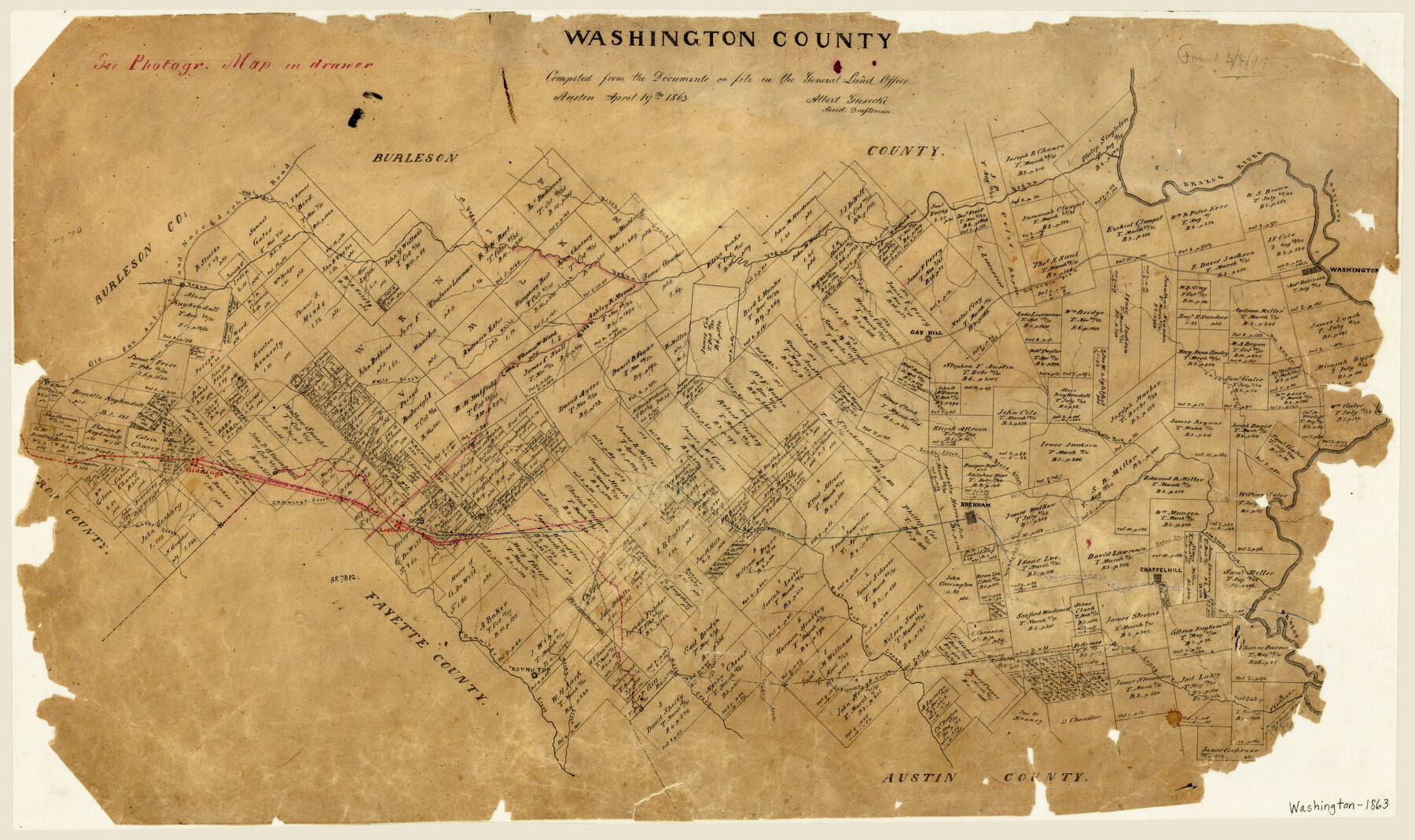
Washington County
-
Map/Doc
4127
-
Collection
General Map Collection
-
Object Dates
1863/4/19 (Creation Date)
-
People and Organizations
Texas General Land Office (Publisher)
Albert Giesecke (Compiler)
Albert Giesecke (Draftsman)
-
Counties
Washington
-
Subjects
County
-
Height x Width
15.9 x 27.2 inches
40.4 x 69.1 cm
-
Medium
paper, manuscript
-
Features
Camp Creek
Sandy Creek
Brenham
New Years Creek
Chappel Hill
Woodward's Creek
East Fork of Mill Creek
Round Top
Rocky Creek
West Mill Creek
Wallnut [sic] Creek
Dogwood Creek
Doe Run Creek
Gay Hill
Old San Antonio and Nacogdoches Road
Kuykendall's Fork [of New Years Creek]
Jackson Creek
Rabbs Creek
Caney Creek
Bear Creek
Nacogdoches Road
Second Yegua Creek
First Yegua Creek
Birch Creek
Brazos River
Navisota [sic] River
Washington
La Bahia Road
Yegua Creek
Cedar Creek
Nails Creek
Elm Creek
Old San Antonio Road
Giddings
Cummings Creek
H&TC
Ledbetter
Part of: General Map Collection
Fort Bend County Rolled Sketch 2

Print $20.00
- Digital $50.00
Fort Bend County Rolled Sketch 2
1954
Size 24.4 x 28.6 inches
Map/Doc 5892
Fort Bend County Sketch File 3a

Print $6.00
- Digital $50.00
Fort Bend County Sketch File 3a
1874
Size 8.3 x 8.0 inches
Map/Doc 22882
Starr County Sketch File D

Print $8.00
- Digital $50.00
Starr County Sketch File D
1892
Size 14.2 x 8.7 inches
Map/Doc 36915
Matagorda County NRC Article 33.136 Sketch 23

Print $76.00
Matagorda County NRC Article 33.136 Sketch 23
2025
Map/Doc 97502
El Paso County Working Sketch 29

Print $40.00
- Digital $50.00
El Paso County Working Sketch 29
1967
Size 43.0 x 64.8 inches
Map/Doc 69051
Controlled Mosaic by Jack Amman Photogrammetric Engineers, Inc - Sheet 37

Print $20.00
- Digital $50.00
Controlled Mosaic by Jack Amman Photogrammetric Engineers, Inc - Sheet 37
1954
Size 20.0 x 24.0 inches
Map/Doc 83492
Pecos County Working Sketch 77

Print $20.00
- Digital $50.00
Pecos County Working Sketch 77
1959
Size 32.0 x 36.4 inches
Map/Doc 71549
Duval County Working Sketch 53

Print $20.00
- Digital $50.00
Duval County Working Sketch 53
1948
Size 34.7 x 37.5 inches
Map/Doc 68777
Fisher County Working Sketch 14

Print $20.00
- Digital $50.00
Fisher County Working Sketch 14
1957
Size 24.9 x 33.1 inches
Map/Doc 69148
Pecos County Sketch File 28

Print $20.00
- Digital $50.00
Pecos County Sketch File 28
1927
Size 23.4 x 21.6 inches
Map/Doc 12168
McMullen County Working Sketch 8

Print $20.00
- Digital $50.00
McMullen County Working Sketch 8
1936
Size 27.2 x 33.0 inches
Map/Doc 70709
Trinity County Sketch File 37

Print $4.00
- Digital $50.00
Trinity County Sketch File 37
1921
Size 11.3 x 8.8 inches
Map/Doc 38591
You may also like
Jefferson County Rolled Sketch 48

Print $20.00
- Digital $50.00
Jefferson County Rolled Sketch 48
1963
Size 28.3 x 34.8 inches
Map/Doc 6403
Trinity County Sketch File 5a

Print $4.00
- Digital $50.00
Trinity County Sketch File 5a
1853
Size 6.9 x 8.0 inches
Map/Doc 38504
Mineral Locality Map of Texas Showing Occurances of Useful Minerals, Rocks, Oil and Gas, and Other Geologic Substances

Print $40.00
- Digital $50.00
Mineral Locality Map of Texas Showing Occurances of Useful Minerals, Rocks, Oil and Gas, and Other Geologic Substances
1945
Size 43.8 x 53.0 inches
Map/Doc 94140
Austin County Boundary File 2

Print $32.00
- Digital $50.00
Austin County Boundary File 2
Size 22.4 x 30.7 inches
Map/Doc 50236
Map of Fayette County

Print $20.00
- Digital $50.00
Map of Fayette County
1865
Size 23.2 x 28.8 inches
Map/Doc 3540
Right-of-Way and Track Map, Texas State Railroad operated by the T. and N. O. R.R. Co.

Print $40.00
- Digital $50.00
Right-of-Way and Track Map, Texas State Railroad operated by the T. and N. O. R.R. Co.
1917
Size 24.6 x 55.8 inches
Map/Doc 64175
El Paso County Rolled Sketch Z59

Print $40.00
- Digital $50.00
El Paso County Rolled Sketch Z59
1915
Size 36.5 x 48.1 inches
Map/Doc 8872
Flight Mission No. DQN-2K, Frame 128, Calhoun County

Print $20.00
- Digital $50.00
Flight Mission No. DQN-2K, Frame 128, Calhoun County
1953
Size 18.6 x 22.3 inches
Map/Doc 84302
Flight Mission No. BRA-6M, Frame 73, Jefferson County

Print $20.00
- Digital $50.00
Flight Mission No. BRA-6M, Frame 73, Jefferson County
1953
Size 18.6 x 22.3 inches
Map/Doc 85417
Concho County Working Sketch 9

Print $20.00
- Digital $50.00
Concho County Working Sketch 9
1950
Size 20.0 x 14.6 inches
Map/Doc 68191
Plat in Pecos County, Texas

Print $20.00
- Digital $50.00
Plat in Pecos County, Texas
1928
Size 42.6 x 35.3 inches
Map/Doc 89831
Hall County Rolled Sketch 6

Print $20.00
- Digital $50.00
Hall County Rolled Sketch 6
Size 24.9 x 41.2 inches
Map/Doc 6050