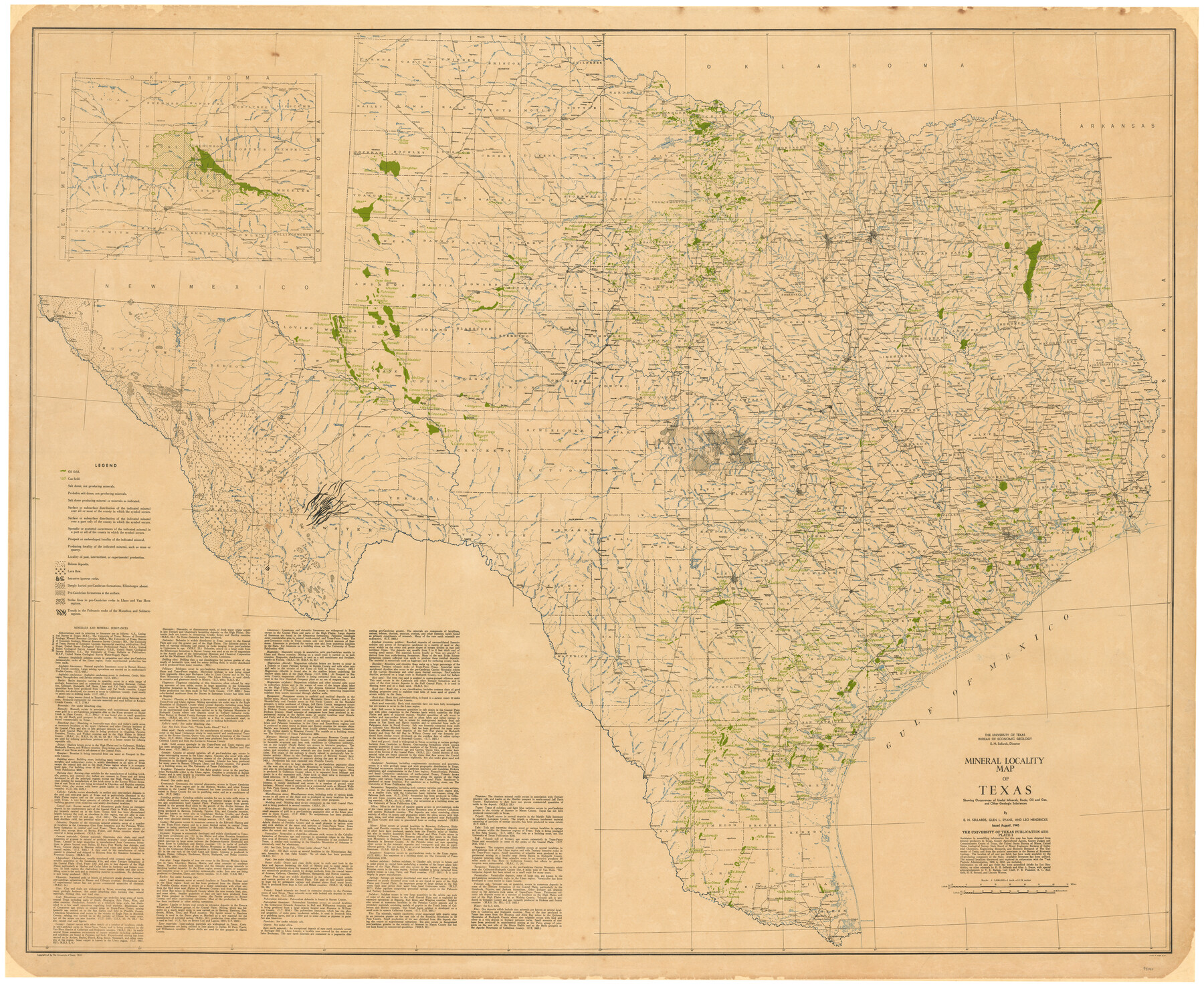
Mineral Locality Map of Texas Showing Occurances of Useful Minerals, Rocks, Oil and Gas, and Other Geologic Substances
N-1-34
-
Map/Doc
94140
-
Collection
General Map Collection
-
Object Dates
8/1945 (Creation Date)
-
People and Organizations
University of Texas (Publisher)
E.H. Sellards (Author)
Glen L. Evans (Author)
Leo Hendricks (Author)
-
Subjects
Energy Surface State of Texas
-
Height x Width
43.8 x 53.0 inches
111.3 x 134.6 cm
-
Medium
paper, etching/engraving/lithograph
-
Scale
1:1,000,000
Part of: General Map Collection
McCulloch County Rolled Sketch 4

Print $40.00
- Digital $50.00
McCulloch County Rolled Sketch 4
1901
Size 48.4 x 14.1 inches
Map/Doc 9498
Crockett County Sketch File 92

Print $21.00
- Digital $50.00
Crockett County Sketch File 92
1925
Size 11.4 x 8.8 inches
Map/Doc 19937
Palo Pinto County

Print $20.00
- Digital $50.00
Palo Pinto County
1856
Size 29.9 x 20.9 inches
Map/Doc 1394
Colorado County Working Sketch 32
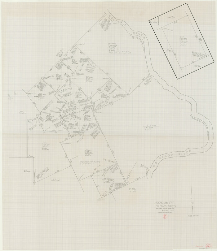
Print $20.00
- Digital $50.00
Colorado County Working Sketch 32
1985
Size 42.7 x 36.8 inches
Map/Doc 68132
Capitol Grounds, Austin

Print $20.00
- Digital $50.00
Capitol Grounds, Austin
Size 35.4 x 40.5 inches
Map/Doc 16955
Orange County Sketch File 32

Print $6.00
- Digital $50.00
Orange County Sketch File 32
1926
Size 14.3 x 8.7 inches
Map/Doc 33360
Taylor County Rolled Sketch 20

Print $20.00
- Digital $50.00
Taylor County Rolled Sketch 20
Size 25.6 x 33.9 inches
Map/Doc 7914
Garza County Working Sketch 15

Print $20.00
- Digital $50.00
Garza County Working Sketch 15
1994
Size 32.2 x 26.9 inches
Map/Doc 63162
Plan of Driving Park Addition composed of Out-lots 37, 38, 39, 49, 50, 60, & 61, Division "O" in the City of Austin

Print $20.00
- Digital $50.00
Plan of Driving Park Addition composed of Out-lots 37, 38, 39, 49, 50, 60, & 61, Division "O" in the City of Austin
1910
Size 18.4 x 15.9 inches
Map/Doc 2024
Atascosa County Working Sketch Graphic Index

Print $20.00
- Digital $50.00
Atascosa County Working Sketch Graphic Index
1948
Size 46.1 x 42.8 inches
Map/Doc 76458
[Right of Way & Track Map, The Texas & Pacific Ry. Co. Main Line]
![64664, [Right of Way & Track Map, The Texas & Pacific Ry. Co. Main Line], General Map Collection](https://historictexasmaps.com/wmedia_w700/maps/64664.tif.jpg)
Print $20.00
- Digital $50.00
[Right of Way & Track Map, The Texas & Pacific Ry. Co. Main Line]
Size 11.0 x 18.5 inches
Map/Doc 64664
Red River County Rolled Sketch 9

Print $20.00
- Digital $50.00
Red River County Rolled Sketch 9
Size 27.1 x 18.1 inches
Map/Doc 7475
You may also like
Starr County Rolled Sketch 29

Print $20.00
- Digital $50.00
Starr County Rolled Sketch 29
1857
Size 35.1 x 30.0 inches
Map/Doc 7812
Briscoe County Rolled Sketch 17

Print $20.00
- Digital $50.00
Briscoe County Rolled Sketch 17
1946
Size 36.7 x 28.7 inches
Map/Doc 5331

General Highway Map, Crockett County, Texas

Print $20.00
General Highway Map, Crockett County, Texas
1961
Size 18.1 x 24.6 inches
Map/Doc 79425
Val Verde County Working Sketch 121

Print $40.00
- Digital $50.00
Val Verde County Working Sketch 121
2005
Size 34.0 x 54.2 inches
Map/Doc 83590

Map of Shackelford County, Texas

Print $20.00
- Digital $50.00
Map of Shackelford County, Texas
1879
Size 28.7 x 23.4 inches
Map/Doc 616
Sterling County Sketch File 1

Print $40.00
- Digital $50.00
Sterling County Sketch File 1
1862
Size 18.7 x 8.4 inches
Map/Doc 37111
Galveston County Rolled Sketch 44

Print $20.00
- Digital $50.00
Galveston County Rolled Sketch 44
1991
Size 25.7 x 37.3 inches
Map/Doc 5975
General Highway Map, Medina County, Texas

Print $20.00
General Highway Map, Medina County, Texas
1961
Size 18.2 x 25.0 inches
Map/Doc 79594
Hockley County Sketch, Mineral Application Number 38245

Print $20.00
- Digital $50.00
Hockley County Sketch, Mineral Application Number 38245
Size 27.2 x 10.8 inches
Map/Doc 91093
Famous Heights Addition to Amarillo, Potter Co. Texas

Print $20.00
- Digital $50.00
Famous Heights Addition to Amarillo, Potter Co. Texas
Size 18.6 x 10.0 inches
Map/Doc 91744