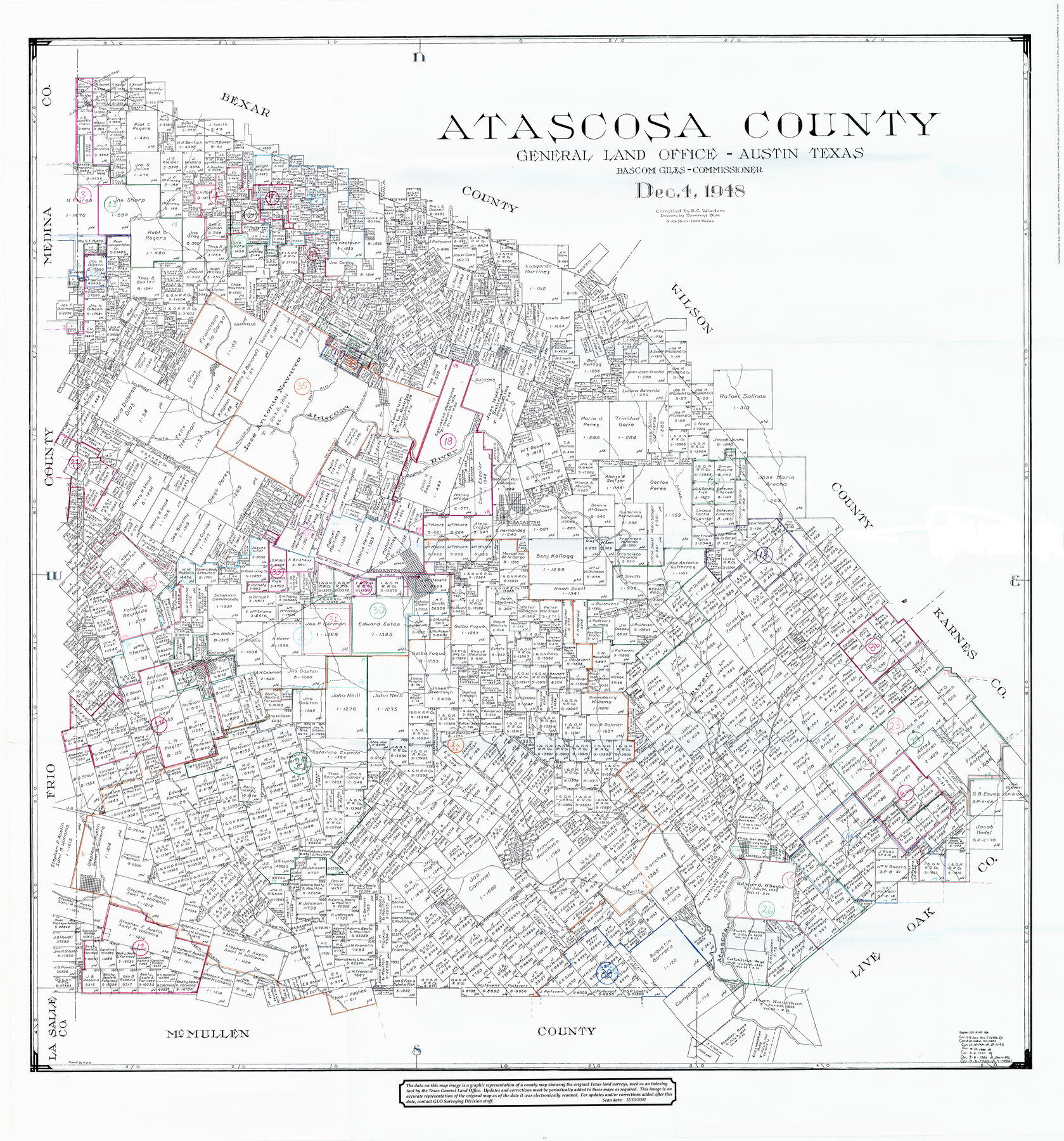
Atascosa County Working Sketch Graphic Index
-
Map/Doc
76458
-
Collection
General Map Collection
-
Object Dates
12/4/1948 (Creation Date)
-
People and Organizations
R.C. Wisdom (Compiler)
Tommye Buie (Draftsman)
-
Counties
Atascosa
-
Subjects
County Surveying Working Sketch
-
Height x Width
46.1 x 42.8 inches
117.1 x 108.7 cm
-
Scale
1" = 2000 varas
Part of: General Map Collection
Travis County Rolled Sketch 47

Print $40.00
- Digital $50.00
Travis County Rolled Sketch 47
1923
Size 57.3 x 26.5 inches
Map/Doc 10626
Armstrong County Working Sketch Graphic Index

Print $20.00
- Digital $50.00
Armstrong County Working Sketch Graphic Index
1933
Size 40.3 x 40.0 inches
Map/Doc 76457
[Map of] North America
![88884, [Map of] North America, General Map Collection](https://historictexasmaps.com/wmedia_w700/maps/88884.tif.jpg)
Print $3.00
- Digital $50.00
[Map of] North America
1834
Size 11.0 x 8.5 inches
Map/Doc 88884
Reeves County Working Sketch 54

Print $20.00
- Digital $50.00
Reeves County Working Sketch 54
1978
Size 36.9 x 35.6 inches
Map/Doc 63497

Gregg County Rolled Sketch 11

Print $20.00
- Digital $50.00
Gregg County Rolled Sketch 11
Size 32.7 x 30.5 inches
Map/Doc 6036
Right of Way & Track Map, St. Louis, Brownsville & Mexico Ry. operated by St. Louis, Brownsville & Mexico Ry. Co.

Print $40.00
- Digital $50.00
Right of Way & Track Map, St. Louis, Brownsville & Mexico Ry. operated by St. Louis, Brownsville & Mexico Ry. Co.
1919
Size 25.5 x 57.1 inches
Map/Doc 64624
Runnels County Working Sketch 26

Print $20.00
- Digital $50.00
Runnels County Working Sketch 26
1956
Size 17.3 x 13.6 inches
Map/Doc 63622
Cameron County Sketch File 7a

Print $32.00
- Digital $50.00
Cameron County Sketch File 7a
1982
Size 11.2 x 8.4 inches
Map/Doc 17115
Carta Eclesiastica

Print $20.00
- Digital $50.00
Carta Eclesiastica
1897
Size 26.1 x 34.1 inches
Map/Doc 96799
Angelina County Sketch File 18c

Print $4.00
- Digital $50.00
Angelina County Sketch File 18c
Size 12.8 x 8.3 inches
Map/Doc 13034
Flight Mission No. BRE-2P, Frame 34, Nueces County

Print $20.00
- Digital $50.00
Flight Mission No. BRE-2P, Frame 34, Nueces County
1956
Size 18.7 x 22.6 inches
Map/Doc 86736
You may also like
Sketch showing connections made in survey of the Jerry Barton preemption

Print $20.00
- Digital $50.00
Sketch showing connections made in survey of the Jerry Barton preemption
1892
Size 18.5 x 23.6 inches
Map/Doc 75558
Irion County Sketch File 5

Print $16.00
- Digital $50.00
Irion County Sketch File 5
1900
Size 14.4 x 8.9 inches
Map/Doc 27463
Gregg County Rolled Sketch 7

Print $20.00
- Digital $50.00
Gregg County Rolled Sketch 7
1933
Size 24.6 x 42.0 inches
Map/Doc 6032
Duval County Working Sketch 10

Print $20.00
- Digital $50.00
Duval County Working Sketch 10
1936
Size 20.1 x 20.3 inches
Map/Doc 68723
Milam County Sketch File 4

Print $4.00
- Digital $50.00
Milam County Sketch File 4
Size 7.6 x 8.2 inches
Map/Doc 31630
Cochran County Sketch File 1

Print $20.00
- Digital $50.00
Cochran County Sketch File 1
Size 44.6 x 32.5 inches
Map/Doc 10337
Flight Mission No. DQO-12K, Frame 36, Galveston County

Print $20.00
- Digital $50.00
Flight Mission No. DQO-12K, Frame 36, Galveston County
1952
Size 18.8 x 22.6 inches
Map/Doc 85227
Pecos County Sketch File 13

Print $20.00
- Digital $50.00
Pecos County Sketch File 13
Size 22.7 x 18.8 inches
Map/Doc 12156
Map of Bandera County, Texas

Print $20.00
- Digital $50.00
Map of Bandera County, Texas
1879
Size 19.6 x 32.6 inches
Map/Doc 691
[Sketch of Unknown Area in New Mexico]
![93027, [Sketch of Unknown Area in New Mexico], Twichell Survey Records](https://historictexasmaps.com/wmedia_w700/maps/93027-1.tif.jpg)
Print $40.00
- Digital $50.00
[Sketch of Unknown Area in New Mexico]
Size 50.6 x 37.1 inches
Map/Doc 93027
Clay County Sketch File 41

Print $6.00
- Digital $50.00
Clay County Sketch File 41
1949
Size 14.2 x 8.6 inches
Map/Doc 18482
Aransas County Rolled Sketch 27

Print $20.00
- Digital $50.00
Aransas County Rolled Sketch 27
1983
Size 24.9 x 35.4 inches
Map/Doc 5059