Irion County Sketch File 5
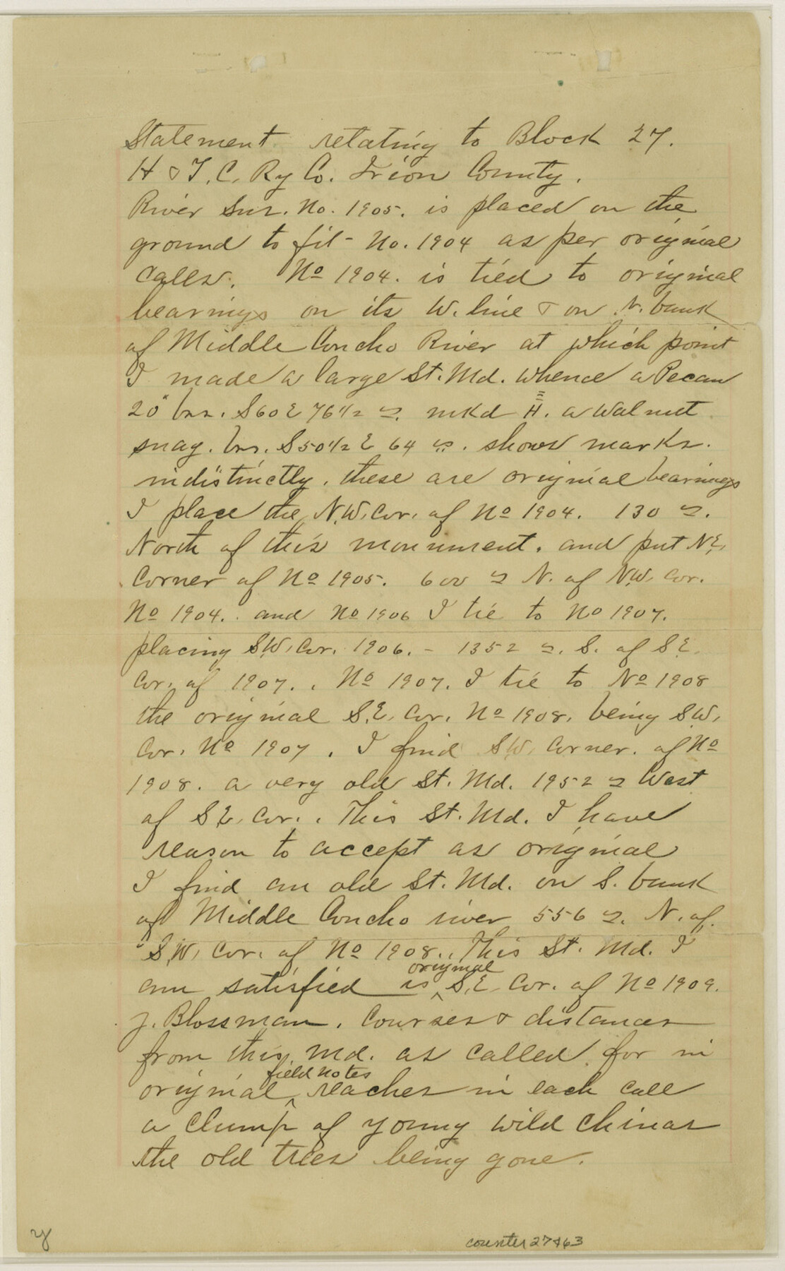
[Statement regarding H. & T. C. RR. Co. Block 27]
-
Map/Doc
27463
-
Collection
General Map Collection
-
Object Dates
1900/3/30 (Creation Date)
1901/2/4 (File Date)
1886 (Survey Date)
1914 (Survey Date)
1913 (Survey Date)
1900/3/30 (Survey Date)
-
People and Organizations
George M. Williams (Surveyor/Engineer)
Neyland (Surveyor/Engineer)
C.D. Foote (Surveyor/Engineer)
-
Counties
Irion
-
Subjects
Surveying Sketch File
-
Height x Width
14.4 x 8.9 inches
36.6 x 22.6 cm
-
Medium
paper, manuscript
-
Features
Middle Concho River
Kiawa Creek
Majors Creek
Part of: General Map Collection
Glasscock County Rolled Sketch 16

Print $40.00
- Digital $50.00
Glasscock County Rolled Sketch 16
1986
Size 63.3 x 46.1 inches
Map/Doc 9060
Hudspeth County Working Sketch 48

Print $20.00
- Digital $50.00
Hudspeth County Working Sketch 48
1984
Size 36.6 x 46.3 inches
Map/Doc 66333
Jefferson County Rolled Sketch 25

Print $20.00
- Digital $50.00
Jefferson County Rolled Sketch 25
1939
Size 43.4 x 36.0 inches
Map/Doc 9290


San Patricio County Rolled Sketch 29A

Print $20.00
- Digital $50.00
San Patricio County Rolled Sketch 29A
1934
Size 37.7 x 45.7 inches
Map/Doc 9895
Edwards County

Print $40.00
- Digital $50.00
Edwards County
1900
Size 56.7 x 36.3 inches
Map/Doc 87470
Bosque County Sketch File 30

Print $6.00
- Digital $50.00
Bosque County Sketch File 30
Size 7.6 x 7.6 inches
Map/Doc 14819
Collin County Boundary File 18d

Print $20.00
- Digital $50.00
Collin County Boundary File 18d
Size 12.8 x 8.2 inches
Map/Doc 51739
Hood County Sketch File 7

Print $6.00
- Digital $50.00
Hood County Sketch File 7
Size 12.9 x 7.9 inches
Map/Doc 26581
Flight Mission No. BRA-7M, Frame 22, Jefferson County

Print $20.00
- Digital $50.00
Flight Mission No. BRA-7M, Frame 22, Jefferson County
1953
Size 18.5 x 22.2 inches
Map/Doc 85473
Flight Mission No. DQN-7K, Frame 33, Calhoun County

Print $20.00
- Digital $50.00
Flight Mission No. DQN-7K, Frame 33, Calhoun County
1953
Size 18.5 x 22.1 inches
Map/Doc 84471
You may also like
Zapata County Sketch File 4a

Print $4.00
- Digital $50.00
Zapata County Sketch File 4a
1891
Size 14.2 x 8.8 inches
Map/Doc 40908

Hale County Sketch File 4

Print $20.00
- Digital $50.00
Hale County Sketch File 4
1891
Size 18.8 x 16.4 inches
Map/Doc 11594
Dallas County Boundary File 8 and 8a

Print $16.00
- Digital $50.00
Dallas County Boundary File 8 and 8a
Size 11.3 x 8.6 inches
Map/Doc 52304
Harris County Historic Topographic 12

Print $20.00
- Digital $50.00
Harris County Historic Topographic 12
1915
Size 19.5 x 23.5 inches
Map/Doc 65822
San Antonio - Places of Interest and how to get there

San Antonio - Places of Interest and how to get there
1920
Map/Doc 96785
Webb County Working Sketch 25

Print $20.00
- Digital $50.00
Webb County Working Sketch 25
1928
Size 38.8 x 31.2 inches
Map/Doc 72390

Gray's Geological Map of the United States

Print $20.00
- Digital $50.00
Gray's Geological Map of the United States
1873
Size 17.6 x 28.8 inches
Map/Doc 95174
Houston County Working Sketch 19

Print $20.00
- Digital $50.00
Houston County Working Sketch 19
1976
Size 33.6 x 24.2 inches
Map/Doc 66249
East Line of Lipscomb County

Print $20.00
- Digital $50.00
East Line of Lipscomb County
Size 8.9 x 21.7 inches
Map/Doc 91317
Austin's Register of Families Vol. 1

Austin's Register of Families Vol. 1
Size 14.0 x 10.2 inches
Map/Doc 94249