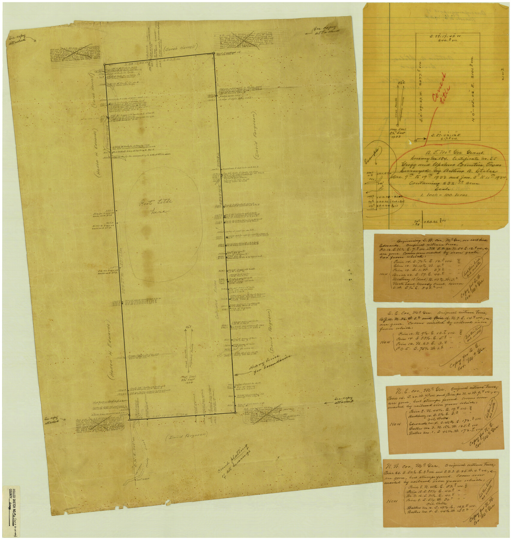
Gregg County Rolled Sketch 11
[Report and sketch of A. McGee survey in Gregg & Upshur Counties]
-
Map/Doc
6036
-
Collection
General Map Collection
-
Counties
Gregg Upshur
-
Subjects
Surveying Rolled Sketch
-
Height x Width
32.7 x 30.5 inches
83.1 x 77.5 cm
-
Medium
paper, manuscript
Part of: General Map Collection
La Salle County Sketch File 13

Print $6.00
- Digital $50.00
La Salle County Sketch File 13
Size 8.1 x 16.6 inches
Map/Doc 29477
Map of Bexar County

Print $20.00
- Digital $50.00
Map of Bexar County
1896
Size 46.2 x 39.9 inches
Map/Doc 4766
Lamar County State Real Property Sketch 1

Print $20.00
- Digital $50.00
Lamar County State Real Property Sketch 1
2013
Size 24.0 x 36.0 inches
Map/Doc 93659
Concho County Sketch File 10

Print $20.00
- Digital $50.00
Concho County Sketch File 10
1887
Size 23.1 x 33.8 inches
Map/Doc 11150
Controlled Mosaic by Jack Amman Photogrammetric Engineers, Inc - Sheet 33

Print $20.00
- Digital $50.00
Controlled Mosaic by Jack Amman Photogrammetric Engineers, Inc - Sheet 33
1954
Size 20.0 x 24.0 inches
Map/Doc 83486
Map of Nolan County

Print $20.00
- Digital $50.00
Map of Nolan County
1902
Size 45.9 x 38.4 inches
Map/Doc 16780
Oldham County Sketch File 15

Print $6.00
- Digital $50.00
Oldham County Sketch File 15
1904
Size 11.2 x 8.5 inches
Map/Doc 33261
San Patricio County Rolled Sketch 47

Print $20.00
- Digital $50.00
San Patricio County Rolled Sketch 47
1939
Size 27.6 x 29.6 inches
Map/Doc 7731
Mapa del Rio Grande desde su Desembocadura en el Golfo hasta San Vicente, Presidio Antíguo

Print $20.00
- Digital $50.00
Mapa del Rio Grande desde su Desembocadura en el Golfo hasta San Vicente, Presidio Antíguo
1873
Size 38.1 x 32.3 inches
Map/Doc 97126
Edwards County Rolled Sketch 8

Print $20.00
- Digital $50.00
Edwards County Rolled Sketch 8
1891
Size 16.0 x 18.7 inches
Map/Doc 5801
Sutton County Working Sketch 53

Print $20.00
- Digital $50.00
Sutton County Working Sketch 53
1957
Size 36.1 x 37.5 inches
Map/Doc 62396
Galveston County NRC Article 33.136 Sketch 54

Print $22.00
- Digital $50.00
Galveston County NRC Article 33.136 Sketch 54
2008
Size 24.0 x 36.0 inches
Map/Doc 94848
You may also like
Flight Mission No. BRA-16M, Frame 73, Jefferson County

Print $20.00
- Digital $50.00
Flight Mission No. BRA-16M, Frame 73, Jefferson County
1953
Size 18.7 x 22.3 inches
Map/Doc 85690
Reeves County Rolled Sketch 32

Print $634.00
- Digital $50.00
Reeves County Rolled Sketch 32
1960
Size 10.2 x 15.4 inches
Map/Doc 48849
McLennan County Sketch File 43

Print $4.00
- Digital $50.00
McLennan County Sketch File 43
1873
Size 10.0 x 8.1 inches
Map/Doc 31333
Pecos County Working Sketch 23

Print $20.00
- Digital $50.00
Pecos County Working Sketch 23
1927
Size 45.6 x 40.6 inches
Map/Doc 71494
Presidio County Working Sketch 86

Print $20.00
- Digital $50.00
Presidio County Working Sketch 86
1971
Size 45.4 x 42.2 inches
Map/Doc 71763
Flight Mission No. DIX-7P, Frame 13, Aransas County

Print $20.00
- Digital $50.00
Flight Mission No. DIX-7P, Frame 13, Aransas County
1956
Size 4.0 x 5.0 inches
Map/Doc 83865

Harris County Historic Topographic 15

Print $20.00
- Digital $50.00
Harris County Historic Topographic 15
1916
Size 29.2 x 22.9 inches
Map/Doc 65825
Flight Mission No. DCL-7C, Frame 11, Kenedy County

Print $20.00
- Digital $50.00
Flight Mission No. DCL-7C, Frame 11, Kenedy County
1943
Size 15.4 x 15.2 inches
Map/Doc 86003
Sutton County Boundary File 3

Print $22.00
- Digital $50.00
Sutton County Boundary File 3
Size 14.2 x 8.7 inches
Map/Doc 59024
Garza County Sketch File 11

Print $4.00
- Digital $50.00
Garza County Sketch File 11
1901
Size 11.3 x 8.8 inches
Map/Doc 24066
Sketch Showing Division Fence Shelton- Matador, Oldham County, Texas

Print $20.00
- Digital $50.00
Sketch Showing Division Fence Shelton- Matador, Oldham County, Texas
Size 21.2 x 23.0 inches
Map/Doc 91427