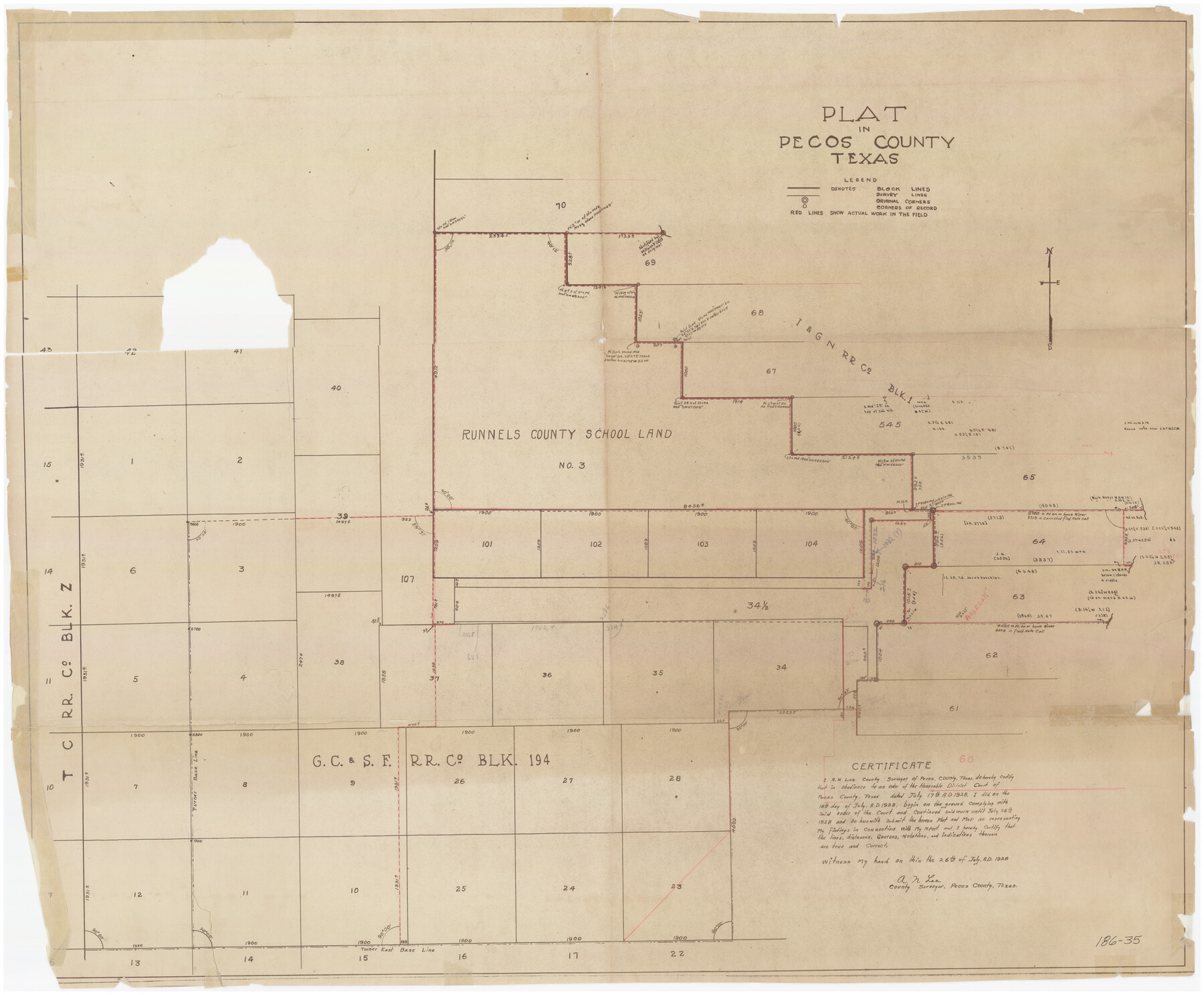
Plat in Pecos County, Texas
186-35
-
Map/Doc
89831
-
Collection
Twichell Survey Records
-
Object Dates
7/26/1928 (Creation Date)
-
People and Organizations
A.N. Lea (Surveyor/Engineer)
-
Counties
Pecos
-
Height x Width
42.6 x 35.3 inches
108.2 x 89.7 cm
Part of: Twichell Survey Records
[Worksheets related to the Wilson Strickland survey and vicinity]
![91265, [Vicinity and related to the Wilson Strickland Survey], Twichell Survey Records](https://historictexasmaps.com/wmedia_w700/maps/91265-1.tif.jpg)
Print $20.00
- Digital $50.00
[Worksheets related to the Wilson Strickland survey and vicinity]
Size 39.0 x 11.6 inches
Map/Doc 91265
Subdivision Map of Fisher County School Land situated in Bailey and Cochran Counties, Texas

Print $20.00
- Digital $50.00
Subdivision Map of Fisher County School Land situated in Bailey and Cochran Counties, Texas
1924
Size 17.3 x 21.3 inches
Map/Doc 90111
[Blocks M1 and 3T]
![91515, [Blocks M1 and 3T], Twichell Survey Records](https://historictexasmaps.com/wmedia_w700/maps/91515-1.tif.jpg)
Print $20.00
- Digital $50.00
[Blocks M1 and 3T]
Size 10.1 x 26.3 inches
Map/Doc 91515
[Leagues 302- 308, 315- 318, Portions of Blocks S and M19, on Oldham-Potter County Line]
![91481, [Leagues 302- 308, 315- 318, Portions of Blocks S and M19, on Oldham-Potter County Line], Twichell Survey Records](https://historictexasmaps.com/wmedia_w700/maps/91481-1.tif.jpg)
Print $20.00
- Digital $50.00
[Leagues 302- 308, 315- 318, Portions of Blocks S and M19, on Oldham-Potter County Line]
Size 22.4 x 15.7 inches
Map/Doc 91481
Hockley County Sketch Mineral Application Number 38245

Print $20.00
- Digital $50.00
Hockley County Sketch Mineral Application Number 38245
1946
Size 40.6 x 18.5 inches
Map/Doc 92243
Section E Tech Memorial Park, Inc.

Print $20.00
- Digital $50.00
Section E Tech Memorial Park, Inc.
Size 30.9 x 19.1 inches
Map/Doc 92301
[Sketch of part of G. & M. Block 5, G. & M. Block 4, Block M19 and Block 21W]
![93113, [Sketch of part of G. & M. Block 5, G. & M. Block 4, Block M19 and Block 21W], Twichell Survey Records](https://historictexasmaps.com/wmedia_w700/maps/93113-1.tif.jpg)
Print $20.00
- Digital $50.00
[Sketch of part of G. & M. Block 5, G. & M. Block 4, Block M19 and Block 21W]
Size 22.0 x 17.0 inches
Map/Doc 93113
The California Case

Print $20.00
- Digital $50.00
The California Case
Size 17.6 x 12.5 inches
Map/Doc 91696
Sketch in Crockett County [showing University Land Blocks 42 and 45 and Block A-B]
![90313, Sketch in Crockett County [showing University Land Blocks 42 and 45 and Block A-B], Twichell Survey Records](https://historictexasmaps.com/wmedia_w700/maps/90313-1.tif.jpg)
Print $20.00
- Digital $50.00
Sketch in Crockett County [showing University Land Blocks 42 and 45 and Block A-B]
1913
Size 24.6 x 11.9 inches
Map/Doc 90313
[Portion of Block 178, Block C3 and Sections 48-65, Block 1, I. & G. N.]
![91648, [Portion of Block 178, Block C3 and Sections 48-65, Block 1, I. & G. N.], Twichell Survey Records](https://historictexasmaps.com/wmedia_w700/maps/91648-1.tif.jpg)
Print $2.00
- Digital $50.00
[Portion of Block 178, Block C3 and Sections 48-65, Block 1, I. & G. N.]
Size 9.1 x 14.7 inches
Map/Doc 91648
Sketch Showing Division Fence Shelton-Matador

Print $20.00
- Digital $50.00
Sketch Showing Division Fence Shelton-Matador
Size 21.3 x 24.1 inches
Map/Doc 91446
[Coleman County Sections 359, 360, and 361]
![92553, [Coleman County Sections 359, 360, and 361], Twichell Survey Records](https://historictexasmaps.com/wmedia_w700/maps/92553-1.tif.jpg)
Print $20.00
- Digital $50.00
[Coleman County Sections 359, 360, and 361]
Size 17.6 x 22.5 inches
Map/Doc 92553
You may also like
Pecos County Sketch File 110

Print $22.00
- Digital $50.00
Pecos County Sketch File 110
1913
Size 12.9 x 8.8 inches
Map/Doc 34041
Sutton County Sketch File 27

Print $20.00
- Digital $50.00
Sutton County Sketch File 27
Size 38.8 x 15.1 inches
Map/Doc 10377
Erath County Sketch File 19

Print $4.00
- Digital $50.00
Erath County Sketch File 19
1891
Size 8.4 x 12.9 inches
Map/Doc 22298
Section P Tech Memorial Park, Inc.

Print $20.00
- Digital $50.00
Section P Tech Memorial Park, Inc.
1953
Size 21.1 x 32.3 inches
Map/Doc 92353
A Map of California with Descriptive Notes

A Map of California with Descriptive Notes
1954
Size 29.5 x 37.6 inches
Map/Doc 92394
Kendall County Sketch File 7

Print $4.00
- Digital $50.00
Kendall County Sketch File 7
1848
Size 8.2 x 10.4 inches
Map/Doc 28688
Pecos County Sketch File 49b

Print $6.00
- Digital $50.00
Pecos County Sketch File 49b
1920
Size 16.9 x 11.8 inches
Map/Doc 33766
Tyler County Sketch File A1

Print $22.00
- Digital $50.00
Tyler County Sketch File A1
Size 12.7 x 15.7 inches
Map/Doc 38605
Jack County Working Sketch 9

Print $20.00
- Digital $50.00
Jack County Working Sketch 9
1955
Size 35.3 x 29.9 inches
Map/Doc 66435
Topographisch-geognostische Karte von Texas mit Zugrundelegung der geographischen Karte v. Wilson nach eigenen Beobachtungen bearbeitet von Dr. Ferd. Roemer

Print $20.00
- Digital $50.00
Topographisch-geognostische Karte von Texas mit Zugrundelegung der geographischen Karte v. Wilson nach eigenen Beobachtungen bearbeitet von Dr. Ferd. Roemer
1849
Size 23.5 x 21.0 inches
Map/Doc 96523
Brazoria County Sketch File 55

Print $80.00
- Digital $50.00
Brazoria County Sketch File 55
1899
Size 14.9 x 55.0 inches
Map/Doc 10327
Kent County Working Sketch 3a

Print $20.00
- Digital $50.00
Kent County Working Sketch 3a
1948
Size 24.5 x 18.6 inches
Map/Doc 70009