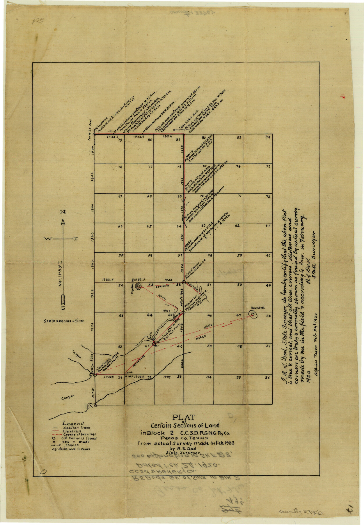
Pecos County Sketch File 49b
[Sketch of surveys in Block 2, C. C. S. D. & R. G. N. G. RR. Co.]
-
Map/Doc
33766
-
Collection
General Map Collection
-
Object Dates
2/24/1920 (Creation Date)
2/1920 (Survey Date)
-
People and Organizations
R.S. Dod (Surveyor/Engineer)
-
Counties
Pecos Terrell
-
Subjects
Surveying Sketch File
-
Height x Width
16.9 x 11.8 inches
42.9 x 30.0 cm
-
Medium
paper, manuscript
-
Scale
1" = 2000 varas
-
Features
Cap Stone Mountain
Round Mountain
Part of: General Map Collection
Erath County Working Sketch 15

Print $20.00
- Digital $50.00
Erath County Working Sketch 15
1961
Size 19.8 x 15.4 inches
Map/Doc 69096
Hansford County

Print $20.00
- Digital $50.00
Hansford County
1932
Size 39.6 x 38.5 inches
Map/Doc 77301
Map of San Augustine County

Print $20.00
- Digital $50.00
Map of San Augustine County
1841
Size 20.5 x 16.9 inches
Map/Doc 4013
Amistad International Reservoir on Rio Grande 66

Print $20.00
- Digital $50.00
Amistad International Reservoir on Rio Grande 66
1949
Size 28.5 x 39.6 inches
Map/Doc 73351
Leon County Working Sketch 35

Print $20.00
- Digital $50.00
Leon County Working Sketch 35
1978
Size 43.8 x 38.3 inches
Map/Doc 70434
Flight Mission No. CRC-6R, Frame 10, Chambers County

Print $20.00
- Digital $50.00
Flight Mission No. CRC-6R, Frame 10, Chambers County
1956
Size 18.6 x 22.4 inches
Map/Doc 84964
Swisher County Working Sketch 2

Print $20.00
- Digital $50.00
Swisher County Working Sketch 2
1950
Size 21.5 x 21.7 inches
Map/Doc 62413
Fractional Township No. 7 South Range No. 1 West of the Indian Meridian, Indian Territory

Print $20.00
- Digital $50.00
Fractional Township No. 7 South Range No. 1 West of the Indian Meridian, Indian Territory
1898
Size 19.2 x 24.4 inches
Map/Doc 75197
Maps of Gulf Intracoastal Waterway, Texas - Sabine River to the Rio Grande and connecting waterways including ship channels

Print $20.00
- Digital $50.00
Maps of Gulf Intracoastal Waterway, Texas - Sabine River to the Rio Grande and connecting waterways including ship channels
1966
Size 14.5 x 22.3 inches
Map/Doc 61923
Cass County Working Sketch 35

Print $20.00
- Digital $50.00
Cass County Working Sketch 35
1982
Size 23.5 x 44.8 inches
Map/Doc 67938
Gray County Rolled Sketch A

Print $20.00
- Digital $50.00
Gray County Rolled Sketch A
1888
Size 40.4 x 40.8 inches
Map/Doc 9008
Flight Mission No. CLL-1N, Frame 87, Willacy County

Print $20.00
- Digital $50.00
Flight Mission No. CLL-1N, Frame 87, Willacy County
1954
Size 18.3 x 22.0 inches
Map/Doc 87033
You may also like
Map of the City of Corsicana (Navarro County) Texas

Print $40.00
- Digital $50.00
Map of the City of Corsicana (Navarro County) Texas
1963
Size 40.1 x 91.8 inches
Map/Doc 93674
[Sketch of expeditions, trails in Jones, Taylor, Shackelford, Callahan, Buchanan/Stephens and Eastland Counties]
![65406, [Sketch of expeditions, trails in Jones, Taylor, Shackelford, Callahan, Buchanan/Stephens and Eastland Counties], General Map Collection](https://historictexasmaps.com/wmedia_w700/maps/65406.tif.jpg)
Print $4.00
- Digital $50.00
[Sketch of expeditions, trails in Jones, Taylor, Shackelford, Callahan, Buchanan/Stephens and Eastland Counties]
1873
Size 10.7 x 18.1 inches
Map/Doc 65406
Webb County Rolled Sketch 53

Print $40.00
- Digital $50.00
Webb County Rolled Sketch 53
1944
Size 84.0 x 32.3 inches
Map/Doc 63914
Fort Bend County Boundary File 2

Print $8.00
- Digital $50.00
Fort Bend County Boundary File 2
Size 14.3 x 8.9 inches
Map/Doc 53559
The Coast of New Spain from Neuva Vera Cruz to Triste Island

Print $20.00
- Digital $50.00
The Coast of New Spain from Neuva Vera Cruz to Triste Island
1775
Size 21.0 x 28.9 inches
Map/Doc 95919
Edwards County Working Sketch 65

Print $20.00
- Digital $50.00
Edwards County Working Sketch 65
1956
Size 34.0 x 25.0 inches
Map/Doc 68941
Hockley County Working Sketch Graphic Index

Print $20.00
- Digital $50.00
Hockley County Working Sketch Graphic Index
1954
Size 42.3 x 37.8 inches
Map/Doc 76579
Mills County Sketch File 14

Print $4.00
- Digital $50.00
Mills County Sketch File 14
1871
Size 6.8 x 8.0 inches
Map/Doc 31661
Kenedy County Boundary File 2

Print $22.00
- Digital $50.00
Kenedy County Boundary File 2
Size 11.2 x 8.6 inches
Map/Doc 55782
Hutchinson County Working Sketch 28

Print $20.00
- Digital $50.00
Hutchinson County Working Sketch 28
1978
Size 27.1 x 23.1 inches
Map/Doc 66388
Austin County, Texas

Print $20.00
- Digital $50.00
Austin County, Texas
1879
Size 23.5 x 28.8 inches
Map/Doc 689
Walker County Working Sketch 7

Print $20.00
- Digital $50.00
Walker County Working Sketch 7
1935
Size 38.3 x 43.2 inches
Map/Doc 72287