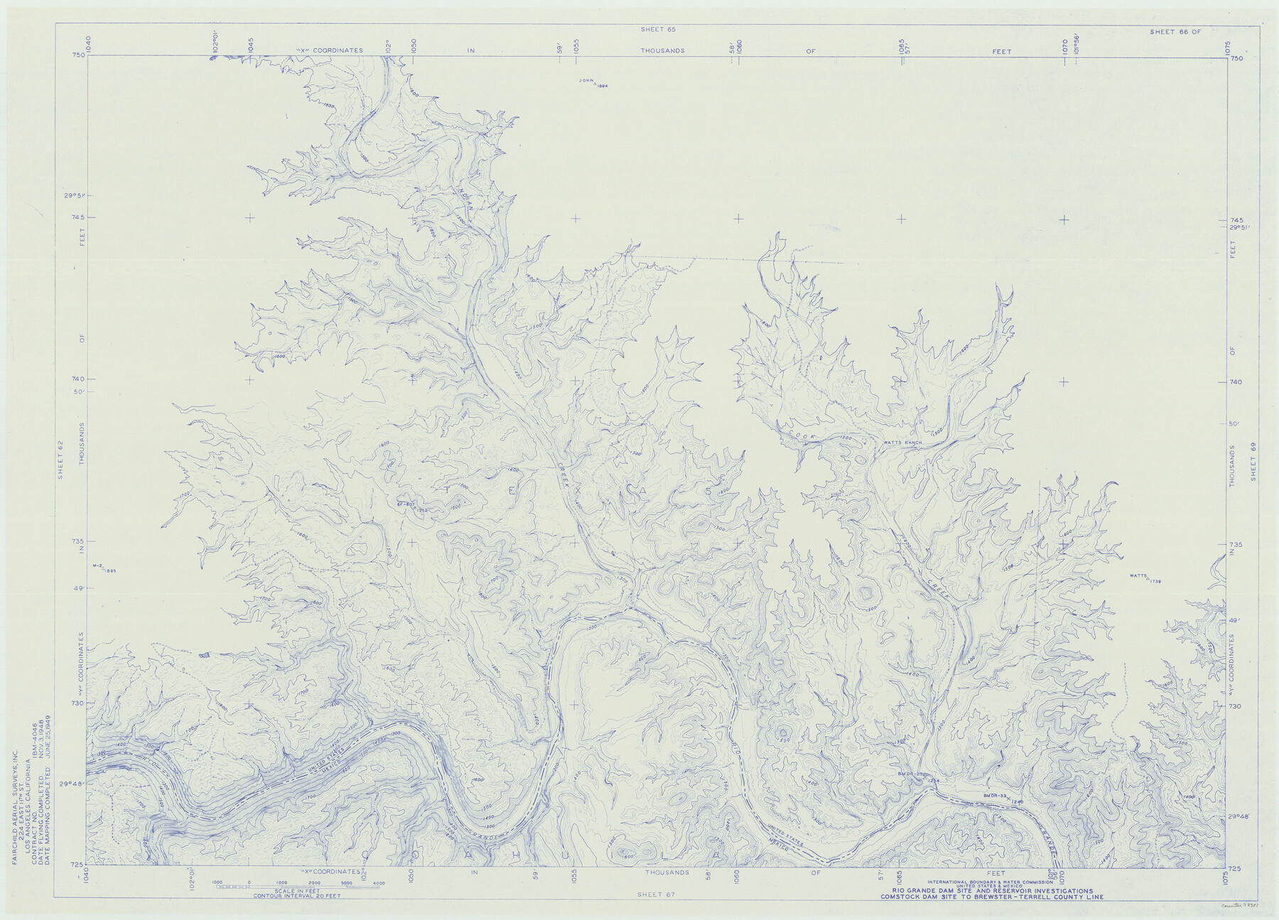
Amistad International Reservoir on Rio Grande 66
Rio Grande Dam Site and Reservoir Investigations
-
Map/Doc
73351
-
Collection
General Map Collection
-
Object Dates
1949/6/25 (Creation Date)
-
People and Organizations
International Boundary and Water Commission (Publisher)
Fairchild Aerial Surveys Inc. (Surveyor/Engineer)
-
Counties
Terrell
-
Subjects
River Surveys Texas Boundaries Topographic
-
Height x Width
28.5 x 39.6 inches
72.4 x 100.6 cm
-
Medium
blueline
-
Comments
Comstock Dam site to Brewster-Terrell County line.
Part of: General Map Collection
Montgomery County Rolled Sketch 19

Print $40.00
- Digital $50.00
Montgomery County Rolled Sketch 19
1933
Size 50.6 x 30.7 inches
Map/Doc 9529

Chambers County Sketch File 26

Print $20.00
- Digital $50.00
Chambers County Sketch File 26
1934
Size 19.6 x 24.6 inches
Map/Doc 11066
Reeves County Working Sketch 33

Print $20.00
- Digital $50.00
Reeves County Working Sketch 33
1970
Size 39.9 x 45.7 inches
Map/Doc 63476
Red River County Working Sketch 16

Print $20.00
- Digital $50.00
Red River County Working Sketch 16
1953
Size 21.8 x 23.4 inches
Map/Doc 71999
Webb County Boundary File 2

Print $12.00
- Digital $50.00
Webb County Boundary File 2
Size 11.3 x 8.7 inches
Map/Doc 59710
El Paso County Boundary File 21

Print $6.00
- Digital $50.00
El Paso County Boundary File 21
Size 15.1 x 9.5 inches
Map/Doc 53214
Brooks County Working Sketch 14

Print $20.00
- Digital $50.00
Brooks County Working Sketch 14
1944
Size 29.2 x 20.0 inches
Map/Doc 67798
Jasper County Boundary File 3

Print $54.00
- Digital $50.00
Jasper County Boundary File 3
Size 9.3 x 31.0 inches
Map/Doc 55480
Parker County Sketch File 30

Print $4.00
- Digital $50.00
Parker County Sketch File 30
Size 6.4 x 7.0 inches
Map/Doc 33570
Robertson County Working Sketch 6

Print $20.00
- Digital $50.00
Robertson County Working Sketch 6
1981
Size 14.1 x 15.9 inches
Map/Doc 63579
Newton County Rolled Sketch 4

Print $20.00
- Digital $50.00
Newton County Rolled Sketch 4
1893
Size 21.1 x 19.7 inches
Map/Doc 6840
You may also like
Tom Green County Sketch File 79B

Print $20.00
- Digital $50.00
Tom Green County Sketch File 79B
1959
Size 18.5 x 23.8 inches
Map/Doc 12451
Runnels County Working Sketch 24

Print $20.00
- Digital $50.00
Runnels County Working Sketch 24
1952
Size 30.6 x 20.0 inches
Map/Doc 63620
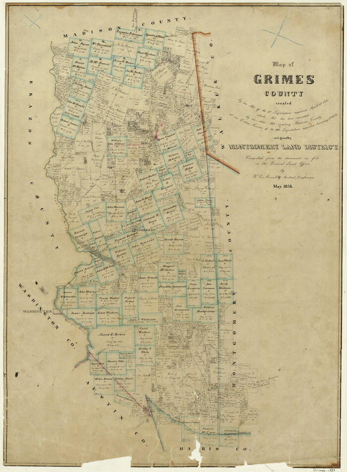
Map of Grimes County
Print $20.00
- Digital $50.00
Map of Grimes County
1858
Size 29.1 x 21.4 inches
Map/Doc 3605
Harris County Working Sketch 67

Print $20.00
- Digital $50.00
Harris County Working Sketch 67
1955
Size 23.3 x 27.5 inches
Map/Doc 65959
[Blocks B16, B7, B15]
![93130, [Blocks B16, B7, B15], Twichell Survey Records](https://historictexasmaps.com/wmedia_w700/maps/93130-1.tif.jpg)
Print $40.00
- Digital $50.00
[Blocks B16, B7, B15]
Size 57.2 x 51.5 inches
Map/Doc 93130
Flight Mission No. DQO-1K, Frame 146, Galveston County

Print $20.00
- Digital $50.00
Flight Mission No. DQO-1K, Frame 146, Galveston County
1952
Size 18.9 x 22.5 inches
Map/Doc 84999
Flight Mission No. BRA-8M, Frame 67, Jefferson County

Print $20.00
- Digital $50.00
Flight Mission No. BRA-8M, Frame 67, Jefferson County
1953
Size 18.8 x 22.5 inches
Map/Doc 85587
Pecos County Sketch File 86

Print $22.00
- Digital $50.00
Pecos County Sketch File 86
1917
Size 13.4 x 9.0 inches
Map/Doc 33964
Map of Galveston, Harrisburg & San Antonio Railway in Pecos County

Print $40.00
- Digital $50.00
Map of Galveston, Harrisburg & San Antonio Railway in Pecos County
1888
Size 26.0 x 80.9 inches
Map/Doc 64399

Fractional Township No. 10 South Range No. 24 East of the Indian Meridian, Indian Territory

Print $20.00
- Digital $50.00
Fractional Township No. 10 South Range No. 24 East of the Indian Meridian, Indian Territory
1898
Size 19.1 x 24.2 inches
Map/Doc 75242
Yellow Fever Deaths in the United States

Yellow Fever Deaths in the United States
2022
Size 8.5 x 11.0 inches
Map/Doc 97093