Fort Bend County Sketch File 3a
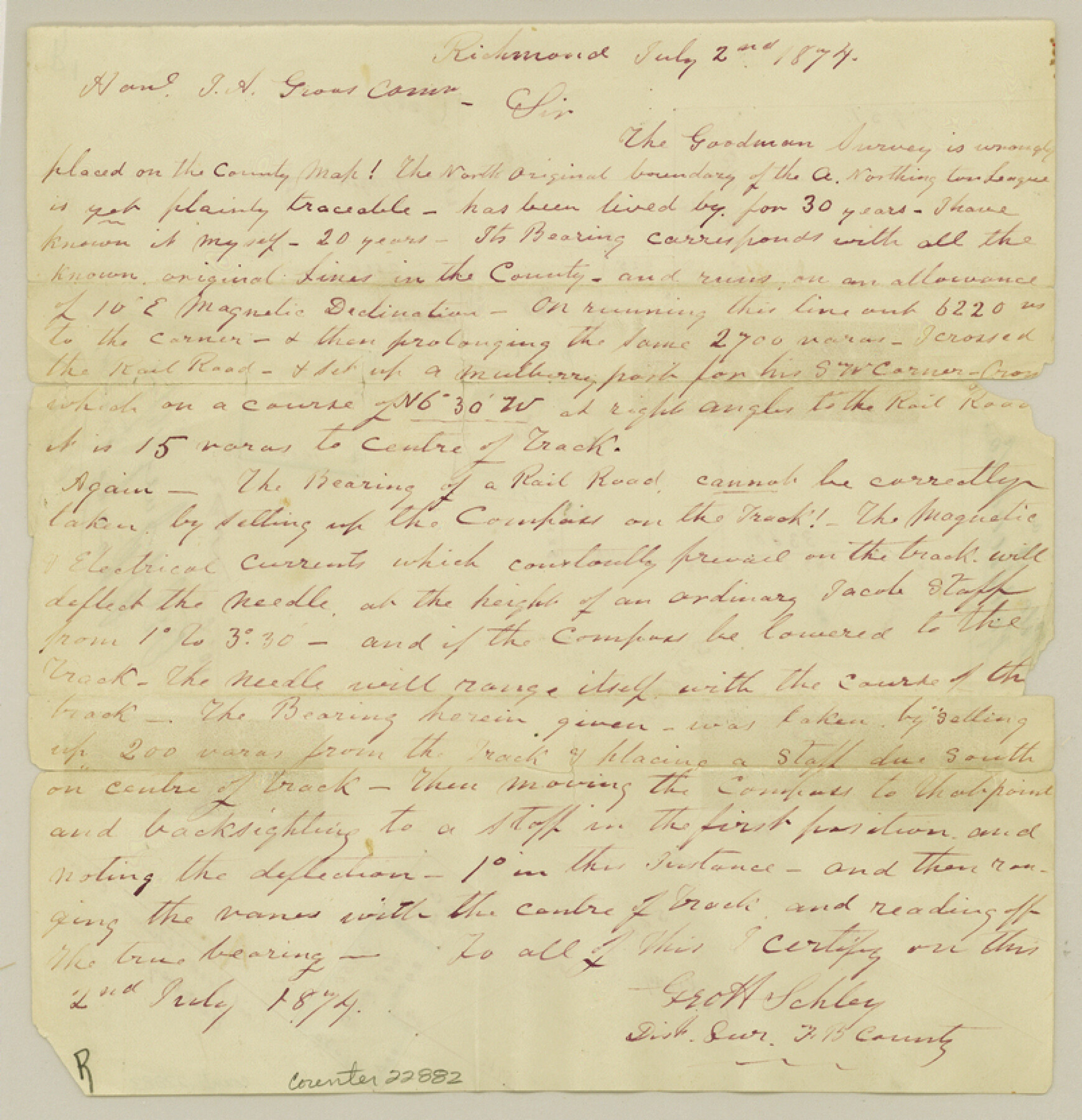
[Sketch of surveys around the W. Worthington tract]
-
Map/Doc
22882
-
Collection
General Map Collection
-
Object Dates
1874/7/2 (Creation Date)
1878/7/16 (File Date)
-
People and Organizations
George H. Schley (Surveyor/Engineer)
-
Counties
Fort Bend
-
Subjects
Surveying Sketch File
-
Height x Width
8.3 x 8.0 inches
21.1 x 20.3 cm
-
Medium
paper, manuscript
Part of: General Map Collection
Map of Madison County

Print $20.00
- Digital $50.00
Map of Madison County
1858
Size 19.8 x 31.7 inches
Map/Doc 3834

Map Showing Location and Right of Way of Proposed Groins - to be built by U.S. Government Along Seawall at Galveston, Texas

Print $20.00
- Digital $50.00
Map Showing Location and Right of Way of Proposed Groins - to be built by U.S. Government Along Seawall at Galveston, Texas
1935
Size 20.8 x 36.3 inches
Map/Doc 73622
Galveston County Rolled Sketch 44

Print $20.00
- Digital $50.00
Galveston County Rolled Sketch 44
1991
Size 24.9 x 36.9 inches
Map/Doc 5973
San Jacinto County Working Sketch 31

Print $20.00
- Digital $50.00
San Jacinto County Working Sketch 31
1953
Size 29.1 x 30.4 inches
Map/Doc 63744
Dallas County Sketch File 15

Print $10.00
- Digital $50.00
Dallas County Sketch File 15
1863
Size 11.5 x 8.5 inches
Map/Doc 20430
Current Miscellaneous File 109

Print $9.00
- Digital $50.00
Current Miscellaneous File 109
1967
Size 9.7 x 10.3 inches
Map/Doc 74710

Rusk County Working Sketch 34

Print $20.00
- Digital $50.00
Rusk County Working Sketch 34
1994
Size 43.5 x 33.1 inches
Map/Doc 63671
Liberty County Working Sketch 49a

Print $20.00
- Digital $50.00
Liberty County Working Sketch 49a
1955
Size 32.7 x 39.9 inches
Map/Doc 70508
McMullen County Working Sketch 25

Print $20.00
- Digital $50.00
McMullen County Working Sketch 25
1952
Size 37.5 x 43.5 inches
Map/Doc 70726
Leon County Sketch File 38

Print $10.00
- Digital $50.00
Leon County Sketch File 38
1999
Size 11.0 x 8.5 inches
Map/Doc 29878
You may also like
Donley County Boundary File 5

Print $4.00
- Digital $50.00
Donley County Boundary File 5
Size 11.2 x 8.8 inches
Map/Doc 52635
Newton County Working Sketch 5

Print $20.00
- Digital $50.00
Newton County Working Sketch 5
1926
Size 16.0 x 20.0 inches
Map/Doc 71251
Falls County Sketch File 27

Print $6.00
- Digital $50.00
Falls County Sketch File 27
Size 16.1 x 11.0 inches
Map/Doc 22436
Bandera County Working Sketch 11

Print $20.00
- Digital $50.00
Bandera County Working Sketch 11
1928
Size 17.8 x 27.4 inches
Map/Doc 67604
Mustang Island, Nueces County

Print $20.00
- Digital $50.00
Mustang Island, Nueces County
1952
Size 39.5 x 35.4 inches
Map/Doc 1918
Natural Heritage of Texas

Print $40.00
- Digital $50.00
Natural Heritage of Texas
1986
Size 54.3 x 56.0 inches
Map/Doc 10786
Lynn County Sketch File 19

Print $36.00
- Digital $50.00
Lynn County Sketch File 19
Size 11.2 x 8.7 inches
Map/Doc 30519
Grimes County Working Sketch 8

Print $20.00
- Digital $50.00
Grimes County Working Sketch 8
1976
Size 35.0 x 32.7 inches
Map/Doc 63299
Intracoastal Waterway - Port Arthur to Galveston Bay

Print $20.00
- Digital $50.00
Intracoastal Waterway - Port Arthur to Galveston Bay
1961
Size 26.7 x 38.8 inches
Map/Doc 69834
Harris County Sketch File 8

Print $23.00
- Digital $50.00
Harris County Sketch File 8
Size 15.3 x 11.9 inches
Map/Doc 25338
Coke County Sketch File A

Print $4.00
- Digital $50.00
Coke County Sketch File A
1881
Size 12.5 x 7.0 inches
Map/Doc 18590
General Highway Map, Starr County, Texas

Print $20.00
General Highway Map, Starr County, Texas
1961
Size 25.1 x 18.3 inches
Map/Doc 79659