Current Miscellaneous File 109
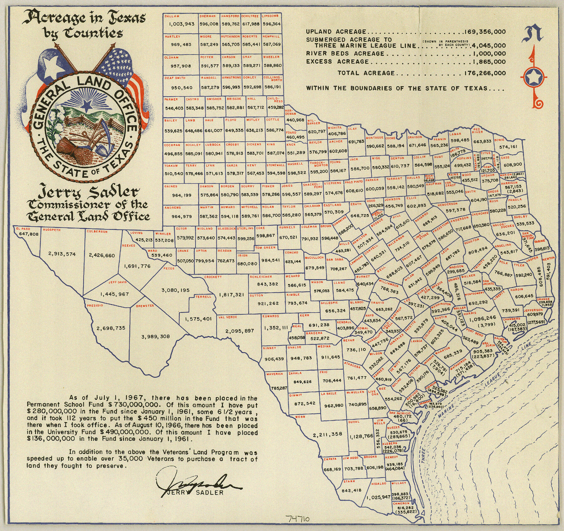
Acreage in Texas by Counties
-
Map/Doc
74710
-
Collection
General Map Collection
-
Object Dates
1967 (Creation Date)
1997/9/2 (File Date)
-
Subjects
County
-
Height x Width
9.7 x 10.3 inches
24.6 x 26.2 cm
Part of: General Map Collection
Flight Mission No. DAH-9M, Frame 205, Orange County

Print $20.00
- Digital $50.00
Flight Mission No. DAH-9M, Frame 205, Orange County
1953
Size 18.7 x 22.6 inches
Map/Doc 86873
Fractional Township No. 7 South Range No. 19 East of the Indian Meridian, Indian Territory

Print $20.00
- Digital $50.00
Fractional Township No. 7 South Range No. 19 East of the Indian Meridian, Indian Territory
1897
Size 19.2 x 24.3 inches
Map/Doc 75235
Sketch showing surveys on Harbor Island in Nueces County

Print $20.00
- Digital $50.00
Sketch showing surveys on Harbor Island in Nueces County
1978
Size 46.4 x 36.0 inches
Map/Doc 2020
Llano County Sketch File 9

Print $42.00
- Digital $50.00
Llano County Sketch File 9
Size 8.6 x 13.1 inches
Map/Doc 30369
Gregg County Working Sketch 15

Print $20.00
- Digital $50.00
Gregg County Working Sketch 15
1941
Size 24.8 x 29.5 inches
Map/Doc 63282
Kerr County Sketch File 18

Print $20.00
- Digital $50.00
Kerr County Sketch File 18
1950
Size 16.9 x 20.3 inches
Map/Doc 11921
Shelby County Rolled Sketch 5

Print $20.00
- Digital $50.00
Shelby County Rolled Sketch 5
1942
Size 37.9 x 43.7 inches
Map/Doc 9921
Lavaca County Sketch File 22

Print $28.00
- Digital $50.00
Lavaca County Sketch File 22
1959
Size 14.2 x 8.7 inches
Map/Doc 29654
Dimmit County Working Sketch 32

Print $20.00
- Digital $50.00
Dimmit County Working Sketch 32
1959
Size 29.2 x 23.3 inches
Map/Doc 68693
Val Verde County Working Sketch 33

Print $20.00
- Digital $50.00
Val Verde County Working Sketch 33
1938
Size 24.4 x 30.7 inches
Map/Doc 72168
Lubbock County Boundary File 1a

Print $20.00
- Digital $50.00
Lubbock County Boundary File 1a
Size 24.8 x 24.4 inches
Map/Doc 56487
Dimmit County Working Sketch 5

Print $20.00
- Digital $50.00
Dimmit County Working Sketch 5
1916
Size 20.0 x 16.5 inches
Map/Doc 68666
You may also like
Atascosa County Sketch File 35

Print $20.00
- Digital $50.00
Atascosa County Sketch File 35
1854
Size 14.4 x 30.0 inches
Map/Doc 10866
Flight Mission No. BRA-3M, Frame 126, Jefferson County

Print $20.00
- Digital $50.00
Flight Mission No. BRA-3M, Frame 126, Jefferson County
1953
Size 18.7 x 21.8 inches
Map/Doc 85400
Colorado County Sketch File 31

Print $4.00
- Digital $50.00
Colorado County Sketch File 31
1838
Size 12.8 x 7.8 inches
Map/Doc 18984
The Mexican Department of Nacogdoches. On the Eve of Texas Independence, 1836

Print $20.00
The Mexican Department of Nacogdoches. On the Eve of Texas Independence, 1836
2020
Size 18.4 x 21.7 inches
Map/Doc 95974
Bowie County Sketch File 4

Print $4.00
- Digital $50.00
Bowie County Sketch File 4
Size 10.8 x 8.4 inches
Map/Doc 14835
Jackson County Rolled Sketch 11

Print $20.00
- Digital $50.00
Jackson County Rolled Sketch 11
1941
Size 45.9 x 34.3 inches
Map/Doc 9260
Atlas B, 1-137, Burnet's Colony

Atlas B, 1-137, Burnet's Colony
Size 13.2 x 18.1 inches
Map/Doc 94537
Moore County Sketch to Accompany Corrected Field Notes of Sections in Block G. & M. 3]
![91415, Moore County Sketch to Accompany Corrected Field Notes of Sections in Block G. & M. 3], Twichell Survey Records](https://historictexasmaps.com/wmedia_w700/maps/91415-1.tif.jpg)
Print $20.00
- Digital $50.00
Moore County Sketch to Accompany Corrected Field Notes of Sections in Block G. & M. 3]
1913
Size 17.9 x 15.0 inches
Map/Doc 91415
Flight Mission No. DQN-2K, Frame 116, Calhoun County

Print $20.00
- Digital $50.00
Flight Mission No. DQN-2K, Frame 116, Calhoun County
1953
Size 18.6 x 22.3 inches
Map/Doc 84292
Reagan County Working Sketch 48

Print $20.00
- Digital $50.00
Reagan County Working Sketch 48
1987
Size 31.6 x 46.1 inches
Map/Doc 71891
Jefferson County Rolled Sketch 22

Print $92.00
- Digital $50.00
Jefferson County Rolled Sketch 22
1936
Size 20.4 x 73.1 inches
Map/Doc 9287
Kleberg County Rolled Sketch 10-18

Print $20.00
- Digital $50.00
Kleberg County Rolled Sketch 10-18
1952
Size 37.3 x 38.2 inches
Map/Doc 9364