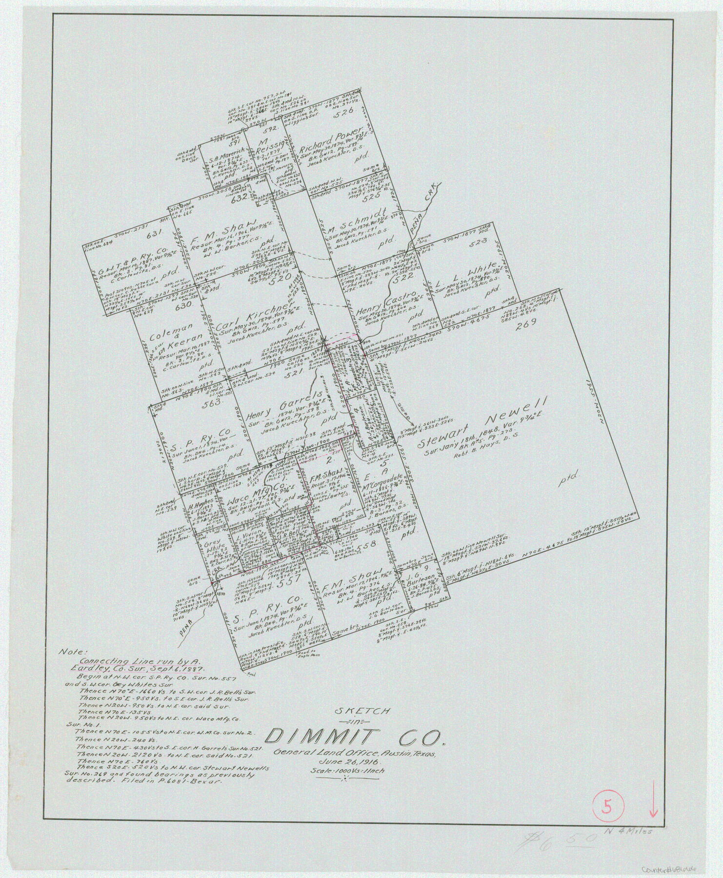
Dimmit County Working Sketch 5
-
Map/Doc
68666
-
Collection
General Map Collection
-
Object Dates
6/26/1916 (Creation Date)
-
Counties
Dimmit
-
Subjects
Surveying Working Sketch
-
Height x Width
20.0 x 16.5 inches
50.8 x 41.9 cm
-
Scale
1" = 1000 varas
Part of: General Map Collection
Callahan County Rolled Sketch 3

Print $20.00
- Digital $50.00
Callahan County Rolled Sketch 3
1948
Size 36.1 x 35.3 inches
Map/Doc 8561
Flight Mission No. CUG-1P, Frame 53, Kleberg County

Print $20.00
- Digital $50.00
Flight Mission No. CUG-1P, Frame 53, Kleberg County
1956
Size 18.6 x 22.4 inches
Map/Doc 86131
Wharton County Sketch File 21

Print $40.00
- Digital $50.00
Wharton County Sketch File 21
1911
Size 14.8 x 13.0 inches
Map/Doc 39986
Flight Mission No. DQO-2K, Frame 98, Galveston County

Print $20.00
- Digital $50.00
Flight Mission No. DQO-2K, Frame 98, Galveston County
1952
Size 18.9 x 22.4 inches
Map/Doc 85025
Donley County Sketch File 26

Print $6.00
- Digital $50.00
Donley County Sketch File 26
Size 12.8 x 8.3 inches
Map/Doc 21261
Crockett County Sketch File 35d

Print $10.00
- Digital $50.00
Crockett County Sketch File 35d
Size 14.2 x 8.9 inches
Map/Doc 19750
Crockett County Rolled Sketch 94

Print $40.00
- Digital $50.00
Crockett County Rolled Sketch 94
1979
Size 45.0 x 49.7 inches
Map/Doc 8738
Jeff Davis County Sketch File 38

Print $8.00
- Digital $50.00
Jeff Davis County Sketch File 38
1952
Size 14.3 x 9.1 inches
Map/Doc 28054
Angelina County Working Sketch 53

Print $40.00
- Digital $50.00
Angelina County Working Sketch 53
1988
Size 42.9 x 58.5 inches
Map/Doc 67137
Wharton County Sketch File 3a

Print $4.00
- Digital $50.00
Wharton County Sketch File 3a
1875
Size 6.8 x 4.6 inches
Map/Doc 39917
Madison County Working Sketch Graphic Index

Print $20.00
- Digital $50.00
Madison County Working Sketch Graphic Index
1922
Size 29.4 x 47.6 inches
Map/Doc 76628
Map of Harris County

Print $20.00
- Digital $50.00
Map of Harris County
1893
Size 26.6 x 34.4 inches
Map/Doc 65810
You may also like
Presidio County Working Sketch 120

Print $20.00
- Digital $50.00
Presidio County Working Sketch 120
1984
Size 34.6 x 28.9 inches
Map/Doc 71797
Coleman County Sketch File A2

Print $5.00
- Digital $50.00
Coleman County Sketch File A2
1879
Size 9.2 x 10.8 inches
Map/Doc 18667
Angelina County Working Sketch 23

Print $20.00
- Digital $50.00
Angelina County Working Sketch 23
1953
Size 19.8 x 32.6 inches
Map/Doc 67105
Flight Mission No. DQN-1K, Frame 129, Calhoun County

Print $20.00
- Digital $50.00
Flight Mission No. DQN-1K, Frame 129, Calhoun County
1953
Size 18.5 x 22.2 inches
Map/Doc 84192
Nueces County Rolled Sketch 4

Print $20.00
- Digital $50.00
Nueces County Rolled Sketch 4
1910
Size 39.8 x 38.5 inches
Map/Doc 9583
Gonzales County Working Sketch 2

Print $20.00
- Digital $50.00
Gonzales County Working Sketch 2
1920
Size 17.6 x 21.5 inches
Map/Doc 63217
[Sketch showing County School Land Surveys in Throckmorton Counties, Texas]
![628, [Sketch showing County School Land Surveys in Throckmorton Counties, Texas], Maddox Collection](https://historictexasmaps.com/wmedia_w700/maps/628-GC.tif.jpg)
Print $20.00
- Digital $50.00
[Sketch showing County School Land Surveys in Throckmorton Counties, Texas]
1889
Size 15.9 x 20.2 inches
Map/Doc 628
Map of Hidalgo County

Print $20.00
- Digital $50.00
Map of Hidalgo County
1896
Size 44.9 x 25.5 inches
Map/Doc 4684
Brazoria County NRC Article 33.136 Sketch 3

Print $20.00
- Digital $50.00
Brazoria County NRC Article 33.136 Sketch 3
2002
Size 40.6 x 29.6 inches
Map/Doc 77039
Eastland County Rolled Sketch B

Print $20.00
- Digital $50.00
Eastland County Rolled Sketch B
1893
Size 27.7 x 40.9 inches
Map/Doc 5774
Bosque County Sketch File 9

Print $6.00
- Digital $50.00
Bosque County Sketch File 9
1859
Size 4.3 x 4.7 inches
Map/Doc 14754
San Saba County Working Sketch 5

Print $20.00
- Digital $50.00
San Saba County Working Sketch 5
1945
Size 30.5 x 22.9 inches
Map/Doc 63793