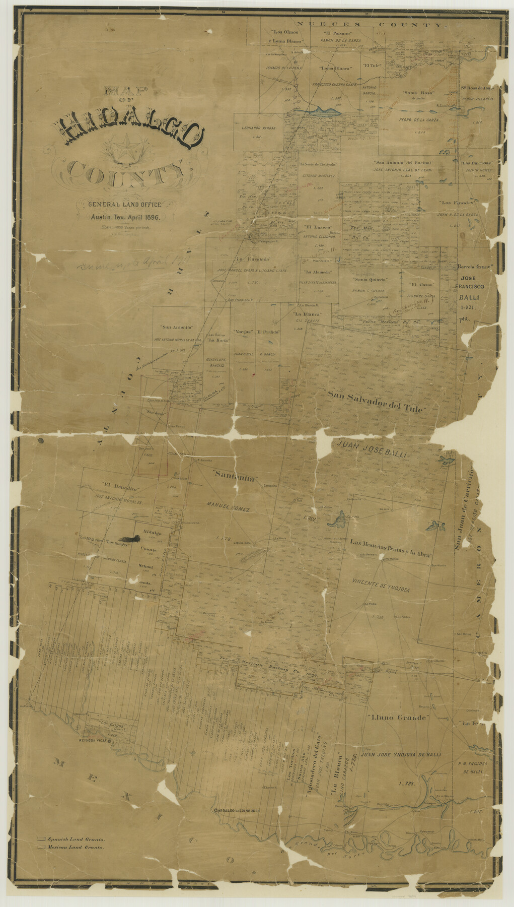
Map of Hidalgo County
-
Map/Doc
4684
-
Collection
General Map Collection
-
Object Dates
1896 (Creation Date)
-
People and Organizations
Texas General Land Office (Publisher)
F.G. Blau (Draftsman)
F.G. Blau (Compiler)
-
Counties
Hidalgo
-
Subjects
County
-
Height x Width
44.9 x 25.5 inches
114.0 x 64.8 cm
-
Comments
Conservation funded in 2002 with donation from Republic Royalty Company.
-
Features
Cibolo Creek
Palo Blanco Creek
Paisano Creek
Los Olmos Creek
La[guna] Tusquita
Laguna Salada
San Antonio Creek
La[guna] de la Jarita
Rancho Gonzalena
Rancho Tepeguajes
Rancho de los Mesquites
Pilar Zarate
Rancho San Francisco
La Cuates de las Vacas
Rancho Las Rucias
Rancho La Blanca
Rancho Santa Quiteria
Tasujica Lake
Rancho San Jose de Arriba
Rancho San Ramon
El Junco Road
Road to Rio Grande City
La[guna] Mestena
La[guna] Pintoballo
Rancho Guadalupe
Rancho Juanita
De la Joya
Rancho Santanita
Rancho El Tule
Rancho EL Rucio
Rancho Costales
Cardaneña
Rancho La Jara
Lago de San Juan
Rancho Lago de Sal Vieja
Rancho San Nicolas
Rancho Santa Monica
Rancho Valla Hermosa
Lago Sal de Rey
Salt Lake
Rancho La Noria
Rancho La Jara
Laguna Seca
Altos Colorados
Rancho Americano
De la Mula
Rancho Matamoros
Rancho Retama
Rancho La Piedra
Rancho Las Petitas
San Matias
Santa Rita
Colimal
Rancho Los Burros
Noria Salado
Alto Verde
Las Cuevas
Rancho Habana
Reynosa Vieja
D. de la Mula
Rancho San Jose
Ovejas
Gediondo
Rancho Tio Cano
Capitanaña
Mala de Maiz
Ojo de Agua
Colorado Creek
Rio Grande del Norte
Rancho de Cabasos
Rancho Laguna Seca
Rancho Tampaguas
Rancho Salto
Falfurias
Rancho Tenajo
D. de Tio Austin
Rancho Ebanito
Sardines Lakes
Hidalgo
Edinburg
Lago de Armagosa
Rancho de los Olmos
Purgatorie
Rancho Naranjado
Rancho de Osa
Job Lake
Badena
Rancho Blanco
Agua Negra
Rancho Reyes
Rosario
Rancho Relampargo
Rancho Balli
Rancho Esterito
Rudyville
Santa Maria
La[guna] Sestiederas
Retama
Reynosa Vieja
La[guna] de San Jose
Rancho Estero de Llano Grande
Rio Grande
Rancho Vieja
Rancho Santa Maria
Part of: General Map Collection
Henderson County Working Sketch 9

Print $20.00
- Digital $50.00
Henderson County Working Sketch 9
1921
Size 30.9 x 16.7 inches
Map/Doc 66142
Houston County Sketch File 1a

Print $4.00
- Digital $50.00
Houston County Sketch File 1a
Size 9.2 x 7.8 inches
Map/Doc 26742
Montague County Working Sketch 32

Print $20.00
- Digital $50.00
Montague County Working Sketch 32
1975
Size 26.0 x 26.1 inches
Map/Doc 71098
Flight Mission No. CUG-3P, Frame 166, Kleberg County

Print $20.00
- Digital $50.00
Flight Mission No. CUG-3P, Frame 166, Kleberg County
1956
Size 18.6 x 22.3 inches
Map/Doc 86286
Webb County Boundary File 3

Print $74.00
- Digital $50.00
Webb County Boundary File 3
Size 11.3 x 8.8 inches
Map/Doc 59716
[Right of Way & Track Map, The Texas & Pacific Ry. Co. Main Line]
![64686, [Right of Way & Track Map, The Texas & Pacific Ry. Co. Main Line], General Map Collection](https://historictexasmaps.com/wmedia_w700/maps/64686.tif.jpg)
Print $20.00
- Digital $50.00
[Right of Way & Track Map, The Texas & Pacific Ry. Co. Main Line]
Size 11.0 x 19.0 inches
Map/Doc 64686
King County Boundary File 5a

Print $40.00
- Digital $50.00
King County Boundary File 5a
Size 10.3 x 38.1 inches
Map/Doc 64922
Chambers County Working Sketch 3

Print $20.00
- Digital $50.00
Chambers County Working Sketch 3
1935
Size 35.9 x 38.8 inches
Map/Doc 67986
Garza County Sketch File 4

Print $6.00
- Digital $50.00
Garza County Sketch File 4
1883
Size 12.6 x 11.0 inches
Map/Doc 24046
Jasper County Sketch File 12a

Print $16.00
- Digital $50.00
Jasper County Sketch File 12a
1881
Size 13.0 x 8.4 inches
Map/Doc 27794
Irion County Sketch File 5

Print $16.00
- Digital $50.00
Irion County Sketch File 5
1900
Size 14.4 x 8.9 inches
Map/Doc 27463

You may also like
Mason County Sketch File 22

Print $8.00
- Digital $50.00
Mason County Sketch File 22
1932
Size 11.1 x 8.9 inches
Map/Doc 30719
Hemphill County Sketch File 3

Print $8.00
- Digital $50.00
Hemphill County Sketch File 3
Size 11.4 x 6.5 inches
Map/Doc 26285
Foard County Rolled Sketch 12

Print $20.00
- Digital $50.00
Foard County Rolled Sketch 12
1945
Size 26.8 x 19.7 inches
Map/Doc 5886
Wise County Working Sketch 18

Print $20.00
- Digital $50.00
Wise County Working Sketch 18
1978
Size 32.8 x 46.5 inches
Map/Doc 72632
Fayette County Sketch File 6

Print $114.00
- Digital $50.00
Fayette County Sketch File 6
1981
Size 14.9 x 9.5 inches
Map/Doc 22508
Kaufman County

Print $20.00
- Digital $50.00
Kaufman County
1871
Size 22.3 x 15.0 inches
Map/Doc 3750
Panola County Rolled Sketch 7

Print $20.00
- Digital $50.00
Panola County Rolled Sketch 7
1957
Size 19.4 x 27.8 inches
Map/Doc 7199
Eastland County Working Sketch 53

Print $20.00
- Digital $50.00
Eastland County Working Sketch 53
1982
Size 22.9 x 27.4 inches
Map/Doc 68834
Chart of the Rio Bravo del Norte traced from a survey made by Henry Austin by Lieut. Bowman, 3d. Infy.

Print $20.00
- Digital $50.00
Chart of the Rio Bravo del Norte traced from a survey made by Henry Austin by Lieut. Bowman, 3d. Infy.
1866
Size 18.1 x 27.2 inches
Map/Doc 72890
Frio County Sketch File 4

Print $4.00
- Digital $50.00
Frio County Sketch File 4
1877
Size 8.0 x 9.6 inches
Map/Doc 23111
Bee County Sketch File 30

Print $6.00
- Digital $50.00
Bee County Sketch File 30
Size 14.2 x 8.9 inches
Map/Doc 14341
Flight Mission No. CRC-4R, Frame 183, Chambers County

Print $20.00
- Digital $50.00
Flight Mission No. CRC-4R, Frame 183, Chambers County
1956
Size 18.5 x 22.2 inches
Map/Doc 84934