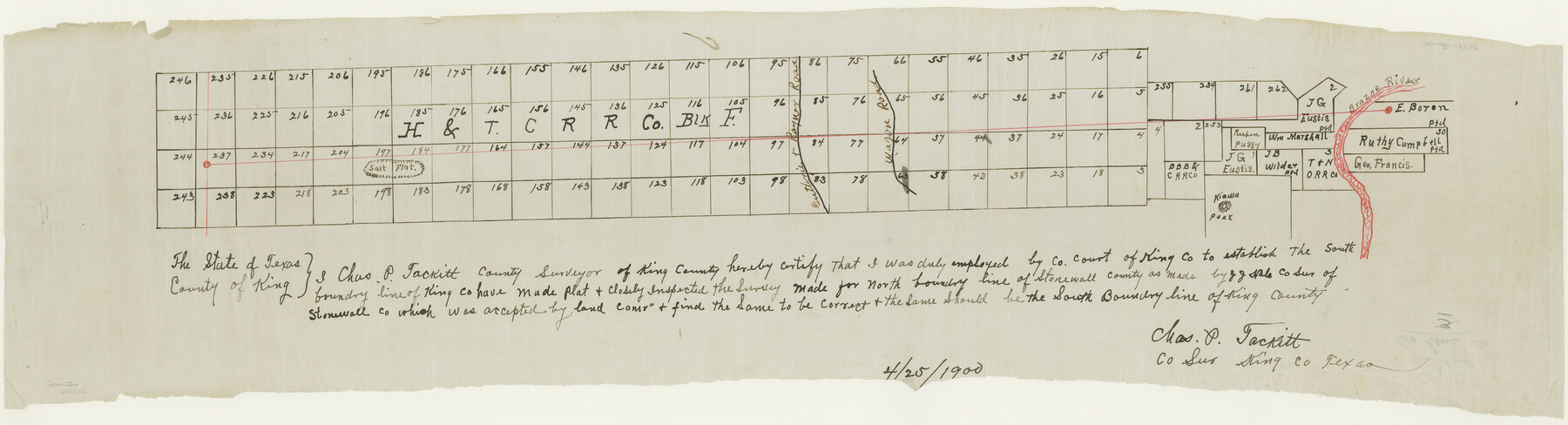
King County Boundary File 5a
-
Map/Doc
64922
-
Collection
General Map Collection
-
Counties
King
-
Subjects
County Boundaries
-
Height x Width
10.3 x 38.1 inches
26.2 x 96.8 cm
Part of: General Map Collection
Cherokee County Sketch File 12b

Print $6.00
- Digital $50.00
Cherokee County Sketch File 12b
1850
Size 7.9 x 7.7 inches
Map/Doc 18142
Jim Hogg County Sketch File 10

Print $22.00
- Digital $50.00
Jim Hogg County Sketch File 10
1947
Size 14.3 x 8.7 inches
Map/Doc 28423
Chart of the West Indies and Spanish Dominions in North America

Print $20.00
- Digital $50.00
Chart of the West Indies and Spanish Dominions in North America
1803
Size 25.7 x 39.4 inches
Map/Doc 97137
Harris County Working Sketch 96

Print $20.00
- Digital $50.00
Harris County Working Sketch 96
1978
Size 18.2 x 26.6 inches
Map/Doc 65988
Dickens County Sketch File B

Print $4.00
- Digital $50.00
Dickens County Sketch File B
1894
Size 14.2 x 8.8 inches
Map/Doc 20831
[Cherokee Reserve, West Boundary Line, plat and field notes]
![2000, [Cherokee Reserve, West Boundary Line, plat and field notes], General Map Collection](https://historictexasmaps.com/wmedia_w700/pdf_converted_jpg/qi_pdf_thumbnail_931.jpg)
Print $54.00
[Cherokee Reserve, West Boundary Line, plat and field notes]
1841
Size 9.4 x 14.7 inches
Map/Doc 2000
Arroyo Colorado, Rio Hondo Sheet

Print $40.00
- Digital $50.00
Arroyo Colorado, Rio Hondo Sheet
1929
Size 35.0 x 52.6 inches
Map/Doc 65129
Collingsworth County Working Sketch 4

Print $20.00
- Digital $50.00
Collingsworth County Working Sketch 4
1960
Size 42.6 x 17.3 inches
Map/Doc 68092
Mills County Working Sketch 2

Print $20.00
- Digital $50.00
Mills County Working Sketch 2
1904
Size 12.7 x 15.8 inches
Map/Doc 71032
Flight Mission No. CRK-5P, Frame 158, Refugio County

Print $20.00
- Digital $50.00
Flight Mission No. CRK-5P, Frame 158, Refugio County
1956
Size 18.6 x 22.5 inches
Map/Doc 86939
Brewster County Rolled Sketch 49

Print $20.00
- Digital $50.00
Brewster County Rolled Sketch 49
1930
Size 35.1 x 47.4 inches
Map/Doc 8478
Flight Mission No. DQN-5K, Frame 76, Calhoun County

Print $20.00
- Digital $50.00
Flight Mission No. DQN-5K, Frame 76, Calhoun County
1953
Size 18.7 x 22.3 inches
Map/Doc 84409
You may also like
El Paso County Working Sketch 6

Print $20.00
- Digital $50.00
El Paso County Working Sketch 6
1928
Size 25.4 x 16.7 inches
Map/Doc 69028
Trinity County Sketch File 9

Print $41.00
- Digital $50.00
Trinity County Sketch File 9
Size 8.5 x 7.8 inches
Map/Doc 38516
Willacy County Aerial Photograph Index Sheet 4

Print $20.00
- Digital $50.00
Willacy County Aerial Photograph Index Sheet 4
1955
Size 24.3 x 19.8 inches
Map/Doc 83759
Brewster County Rolled Sketch 146B

Print $40.00
- Digital $50.00
Brewster County Rolled Sketch 146B
1985
Size 55.5 x 45.2 inches
Map/Doc 8528
The Republic County of Jackson. January 29, 1842

Print $20.00
The Republic County of Jackson. January 29, 1842
2020
Size 15.6 x 21.8 inches
Map/Doc 96189
Burnet County Sketch File 18

Print $4.00
- Digital $50.00
Burnet County Sketch File 18
1873
Size 8.3 x 6.5 inches
Map/Doc 16708
Val Verde County Sketch File AAA3

Print $20.00
- Digital $50.00
Val Verde County Sketch File AAA3
Size 19.1 x 19.2 inches
Map/Doc 12541
Childress County Sketch File 7a

Print $20.00
- Digital $50.00
Childress County Sketch File 7a
Size 14.9 x 17.7 inches
Map/Doc 11080
Haskell County

Print $20.00
- Digital $50.00
Haskell County
1933
Size 45.8 x 39.4 inches
Map/Doc 1852
Upton County Working Sketch 36

Print $40.00
- Digital $50.00
Upton County Working Sketch 36
1957
Size 43.5 x 57.3 inches
Map/Doc 69532
Upshur County Sketch File 20

Print $4.00
- Digital $50.00
Upshur County Sketch File 20
1873
Size 5.7 x 8.3 inches
Map/Doc 38792
[County map showing Texas State Capitol Land and surrounding areas]
![93141, [County map showing Texas State Capitol Land and surrounding areas], Twichell Survey Records](https://historictexasmaps.com/wmedia_w700/maps/93141-1.tif.jpg)
Print $40.00
- Digital $50.00
[County map showing Texas State Capitol Land and surrounding areas]
Size 51.5 x 66.7 inches
Map/Doc 93141