Jim Hogg County Sketch File 10
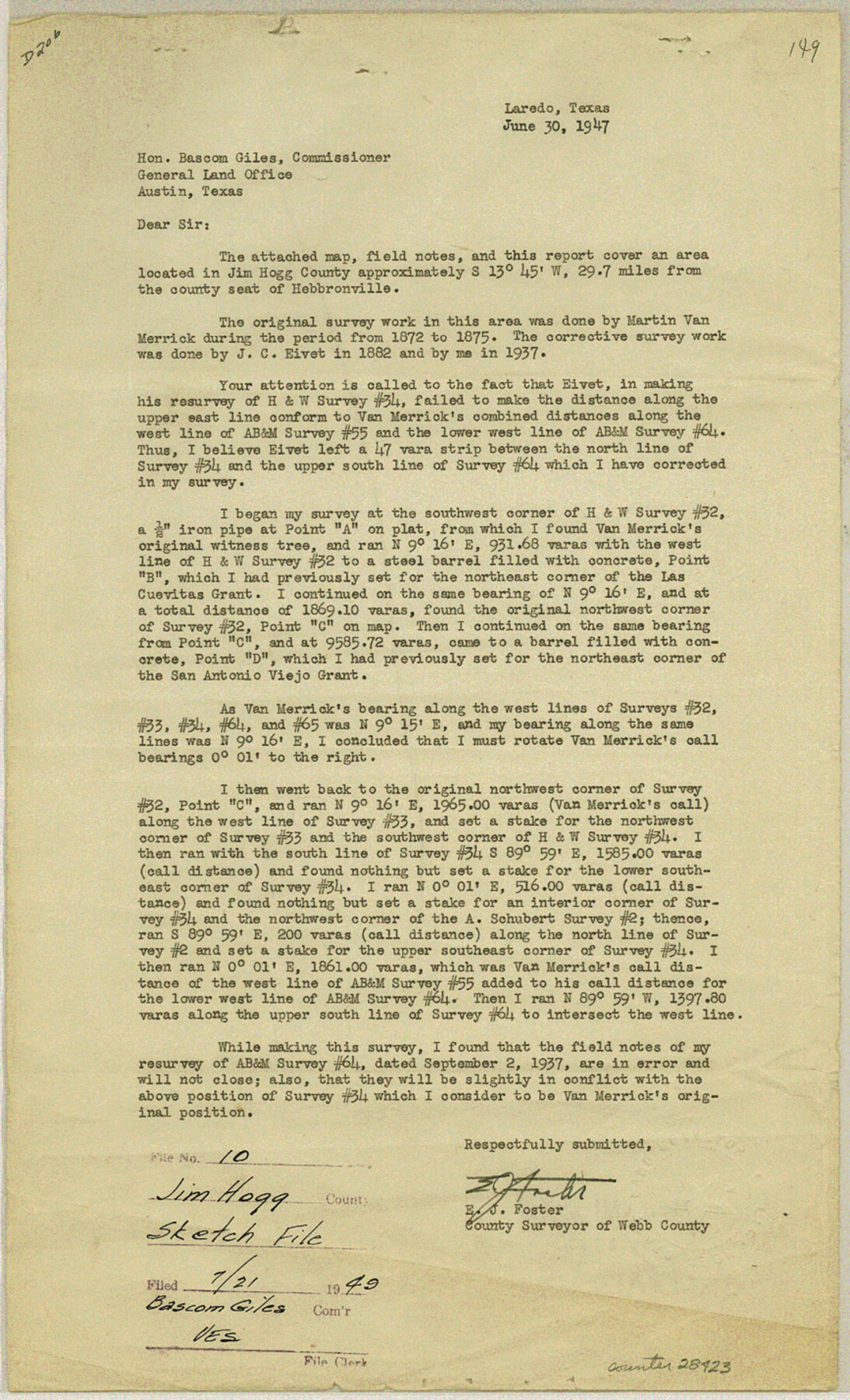
Sketch and Report of a re-survey of Sec. 34, Hooper & Wade
-
Map/Doc
28423
-
Collection
General Map Collection
-
Object Dates
6/30/1947 (Creation Date)
7/21/1949 (File Date)
6/30/1947 (Correspondence Date)
1872 (Survey Date)
1882 (Survey Date)
1937 (Survey Date)
-
People and Organizations
E.J. Foster (Surveyor/Engineer)
Martin Van Merrick (Surveyor/Engineer)
J.C. Eivet (Surveyor/Engineer)
-
Counties
Jim Hogg
-
Subjects
Surveying Sketch File
-
Height x Width
14.3 x 8.7 inches
36.3 x 22.1 cm
-
Medium
multi-page, multi-format
-
Scale
1:500
Part of: General Map Collection
Glasscock County

Print $20.00
- Digital $50.00
Glasscock County
1899
Size 44.2 x 35.5 inches
Map/Doc 4957
Webb County Working Sketch 13

Print $20.00
- Digital $50.00
Webb County Working Sketch 13
1922
Size 14.6 x 11.4 inches
Map/Doc 72378
Presidio County Rolled Sketch 123

Print $40.00
- Digital $50.00
Presidio County Rolled Sketch 123
Size 49.3 x 38.2 inches
Map/Doc 9798
Zapata County Sketch File 13

Print $4.00
- Digital $50.00
Zapata County Sketch File 13
1930
Size 11.3 x 8.8 inches
Map/Doc 40952
Travis County Appraisal District Plat Map 2_2204

Print $20.00
- Digital $50.00
Travis County Appraisal District Plat Map 2_2204
Size 21.6 x 26.4 inches
Map/Doc 94201
Ellis County Sketch File 20

Print $19.00
- Digital $50.00
Ellis County Sketch File 20
1869
Size 12.8 x 8.2 inches
Map/Doc 21869
Baylor County Sketch File 1

Print $6.00
- Digital $50.00
Baylor County Sketch File 1
Size 17.5 x 11.4 inches
Map/Doc 14117
McCulloch County

Print $20.00
- Digital $50.00
McCulloch County
1904
Size 46.9 x 35.9 inches
Map/Doc 66922
Ward County Rolled Sketch 1

Print $40.00
- Digital $50.00
Ward County Rolled Sketch 1
1888
Size 42.6 x 120.4 inches
Map/Doc 76165
Howard County Sketch File 6

Print $44.00
- Digital $50.00
Howard County Sketch File 6
1929
Size 18.6 x 14.4 inches
Map/Doc 26861
Kimble County

Print $40.00
- Digital $50.00
Kimble County
1930
Size 44.8 x 50.3 inches
Map/Doc 95557
Liberty County Working Sketch 19

Print $20.00
- Digital $50.00
Liberty County Working Sketch 19
1940
Size 29.2 x 41.3 inches
Map/Doc 70478
You may also like
Hardin County Working Sketch 37

Print $40.00
- Digital $50.00
Hardin County Working Sketch 37
1981
Size 68.5 x 37.4 inches
Map/Doc 63435
Industrial Site, Imperial State Prison Farm, Sugarland, Texas

Print $20.00
- Digital $50.00
Industrial Site, Imperial State Prison Farm, Sugarland, Texas
Size 26.6 x 27.5 inches
Map/Doc 73562
Coke County Rolled Sketch 5

Print $20.00
- Digital $50.00
Coke County Rolled Sketch 5
1948
Size 25.5 x 23.6 inches
Map/Doc 5505
Maps of Gulf Intracoastal Waterway, Texas - Sabine River to the Rio Grande and connecting waterways including ship channels

Print $20.00
- Digital $50.00
Maps of Gulf Intracoastal Waterway, Texas - Sabine River to the Rio Grande and connecting waterways including ship channels
1966
Size 14.5 x 22.2 inches
Map/Doc 61920
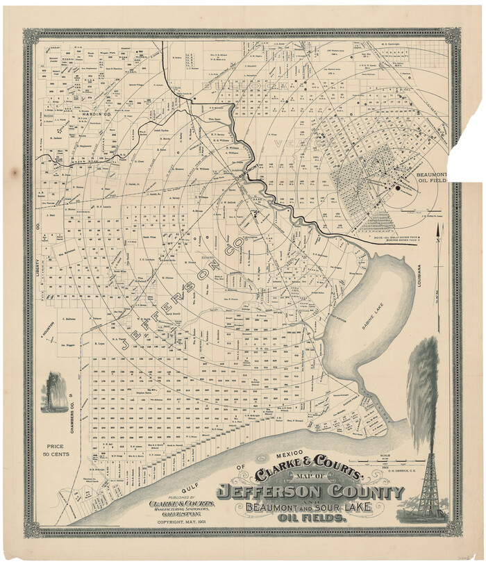
Clarke and Courts' Map of Jefferson County and Beaumont and Sour Lake Oil Fields
Print $20.00
Clarke and Courts' Map of Jefferson County and Beaumont and Sour Lake Oil Fields
1901
Size 28.2 x 24.3 inches
Map/Doc 79289
Brooks County Boundary File 1a

Print $40.00
- Digital $50.00
Brooks County Boundary File 1a
Size 63.8 x 7.1 inches
Map/Doc 50836
Motley County Boundary File 1

Print $46.00
- Digital $50.00
Motley County Boundary File 1
Size 9.0 x 4.1 inches
Map/Doc 57488
Hemphill County Rolled Sketch 17

Print $40.00
- Digital $50.00
Hemphill County Rolled Sketch 17
1965
Size 24.0 x 64.1 inches
Map/Doc 9157
Montgomery County Rolled Sketch 9

Print $20.00
- Digital $50.00
Montgomery County Rolled Sketch 9
1899
Size 19.5 x 20.1 inches
Map/Doc 6795
Lavaca County Working Sketch 16

Print $20.00
- Digital $50.00
Lavaca County Working Sketch 16
1977
Size 25.0 x 24.9 inches
Map/Doc 70369
Brooks County Rolled Sketch 28

Print $20.00
- Digital $50.00
Brooks County Rolled Sketch 28
1947
Size 28.9 x 32.0 inches
Map/Doc 5346
North Shore of West Bay and Galveston Island

Print $40.00
- Digital $50.00
North Shore of West Bay and Galveston Island
1933
Size 37.4 x 57.7 inches
Map/Doc 69930