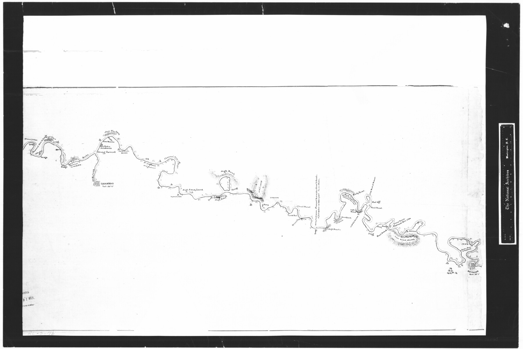
Chart of the Rio Bravo del Norte traced from a survey made by Henry Austin by Lieut. Bowman, 3d. Infy.
RL-3-7b
-
Map/Doc
72890
-
Collection
General Map Collection
-
Object Dates
1866/7/25 (Creation Date)
-
People and Organizations
Bowman (Draftsman)
Henry Austin (Surveyor/Engineer)
-
Subjects
Nautical Charts River Surveys
-
Height x Width
18.1 x 27.2 inches
46.0 x 69.1 cm
-
Comments
B/W photostat copy from National Archives in multiple pieces.
Part of: General Map Collection
Glasscock County

Print $20.00
- Digital $50.00
Glasscock County
1933
Size 47.0 x 39.2 inches
Map/Doc 1839
Morris County Rolled Sketch 2

Print $40.00
- Digital $50.00
Morris County Rolled Sketch 2
1944
Size 59.4 x 43.5 inches
Map/Doc 9550
Taylor County Sketch File 1

Print $20.00
- Digital $50.00
Taylor County Sketch File 1
Size 33.3 x 40.8 inches
Map/Doc 10381
Upton County Sketch File 24

Print $4.00
- Digital $50.00
Upton County Sketch File 24
1928
Size 11.3 x 8.8 inches
Map/Doc 38879
Crockett County Sketch File 73

Print $6.00
- Digital $50.00
Crockett County Sketch File 73
1933
Size 11.2 x 8.7 inches
Map/Doc 19869
Flight Mission No. BRA-7M, Frame 87, Jefferson County

Print $20.00
- Digital $50.00
Flight Mission No. BRA-7M, Frame 87, Jefferson County
1953
Size 18.5 x 22.3 inches
Map/Doc 85509
Zapata County Sketch File 4a

Print $4.00
- Digital $50.00
Zapata County Sketch File 4a
1891
Size 14.2 x 8.8 inches
Map/Doc 40908
Mexico Comision Pesquisidora de la Frontera del Norte

Mexico Comision Pesquisidora de la Frontera del Norte
1874
Map/Doc 97125
Ellis County Sketch File 14

Print $40.00
- Digital $50.00
Ellis County Sketch File 14
1861
Size 12.9 x 16.1 inches
Map/Doc 21854
Louisiana and Texas Intracoastal Waterway, Section 7, Galveston Bay to Brazos River and Section 8, Brazos River to Matagorda Bay

Print $20.00
- Digital $50.00
Louisiana and Texas Intracoastal Waterway, Section 7, Galveston Bay to Brazos River and Section 8, Brazos River to Matagorda Bay
1928
Size 30.7 x 42.9 inches
Map/Doc 61840
Nueces County Rolled Sketch GT

Print $20.00
- Digital $50.00
Nueces County Rolled Sketch GT
1924
Size 24.9 x 38.6 inches
Map/Doc 7169
Webb County Boundary File 7

Print $98.00
- Digital $50.00
Webb County Boundary File 7
Size 14.2 x 8.7 inches
Map/Doc 59809
You may also like
Kendall County Sketch File 7

Print $4.00
- Digital $50.00
Kendall County Sketch File 7
1848
Size 8.2 x 10.4 inches
Map/Doc 28688
Brazoria County Rolled Sketch 37

Print $20.00
- Digital $50.00
Brazoria County Rolled Sketch 37
Size 18.5 x 25.0 inches
Map/Doc 5173
Nueces County Sketch File 66

Print $18.00
- Digital $50.00
Nueces County Sketch File 66
1981
Size 14.3 x 8.8 inches
Map/Doc 32989
Map of The Surveyed Part of Peters Colony Texas

Print $40.00
- Digital $50.00
Map of The Surveyed Part of Peters Colony Texas
1854
Size 53.5 x 65.9 inches
Map/Doc 1967

Maverick County Working Sketch 2

Print $20.00
- Digital $50.00
Maverick County Working Sketch 2
1922
Size 46.2 x 38.5 inches
Map/Doc 70894
Map of the World: and chart exhibiting the size of each country, nation or kingdom, its population as a whole and to a square mile also the different states of society, forms of government, religion &c.

Print $20.00
- Digital $50.00
Map of the World: and chart exhibiting the size of each country, nation or kingdom, its population as a whole and to a square mile also the different states of society, forms of government, religion &c.
1850
Size 12.2 x 19.4 inches
Map/Doc 93882
Map of Llano County Showing Geology, Mineral Localities, Topography, etc.

Print $20.00
Map of Llano County Showing Geology, Mineral Localities, Topography, etc.
1875
Size 16.5 x 21.3 inches
Map/Doc 88969
Terrell County Rolled Sketch 40

Print $20.00
- Digital $50.00
Terrell County Rolled Sketch 40
1943
Size 16.7 x 18.1 inches
Map/Doc 7944
Copy of Surveyor's Field Book, Morris Browning - In Blocks 7, 5 & 4, I&GNRRCo., Hutchinson and Carson Counties, Texas

Print $2.00
- Digital $50.00
Copy of Surveyor's Field Book, Morris Browning - In Blocks 7, 5 & 4, I&GNRRCo., Hutchinson and Carson Counties, Texas
1888
Size 7.0 x 8.8 inches
Map/Doc 62279
Map of Shelby County

Print $20.00
- Digital $50.00
Map of Shelby County
1839
Size 24.5 x 25.7 inches
Map/Doc 4032
Map of the State of Texas from the Latest Authorities

Print $2.00
- Digital $50.00
Map of the State of Texas from the Latest Authorities
1854
Size 5.2 x 3.5 inches
Map/Doc 93902