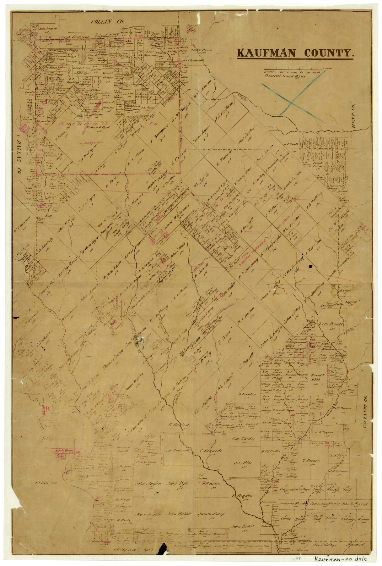
Kaufman County
-
Map/Doc
3750
-
Collection
General Map Collection
-
Object Dates
[1871 ca.] (Creation Date)
-
People and Organizations
Texas General Land Office (Publisher)
-
Counties
Kaufman
-
Subjects
County
-
Height x Width
22.3 x 15.0 inches
56.6 x 38.1 cm
-
Features
Bluff Creek
Rockwall
Kings Fork
Wolf Creek
College Mound Creek
Little Brushy Bayou
Brushy Bayou
Bois d'Arc [Creek]
East Fork
Big Cottonwood Creek
Kaufman
Walnut Creek
Ferris Fork
Lucy Fork
Cedar Creek
Bear Pen Creek
Part of: General Map Collection
Kimble County Working Sketch 92

Print $20.00
- Digital $50.00
Kimble County Working Sketch 92
1979
Size 24.0 x 30.6 inches
Map/Doc 70160
Edwards County

Print $20.00
- Digital $50.00
Edwards County
1893
Size 26.7 x 30.2 inches
Map/Doc 4650
Map of Orange County

Print $20.00
- Digital $50.00
Map of Orange County
1862
Size 13.6 x 16.5 inches
Map/Doc 3929
Nolan County Sketch File 12

Print $20.00
- Digital $50.00
Nolan County Sketch File 12
1924
Size 22.5 x 24.5 inches
Map/Doc 42163
Upton County Rolled Sketch 4

Print $20.00
- Digital $50.00
Upton County Rolled Sketch 4
Size 34.4 x 42.8 inches
Map/Doc 76025
Soil Map - Ohio-Michigan, Toledo Set

Print $20.00
- Digital $50.00
Soil Map - Ohio-Michigan, Toledo Set
1902
Size 21.4 x 30.5 inches
Map/Doc 3023
Map of Titus County

Print $20.00
- Digital $50.00
Map of Titus County
1879
Size 23.3 x 14.7 inches
Map/Doc 4082
Nacogdoches County Working Sketch 2

Print $20.00
- Digital $50.00
Nacogdoches County Working Sketch 2
1904
Size 20.5 x 24.1 inches
Map/Doc 71218
McMullen County Working Sketch 22

Print $40.00
- Digital $50.00
McMullen County Working Sketch 22
1947
Size 39.1 x 53.3 inches
Map/Doc 70723
Map of Wheeler County

Print $20.00
- Digital $50.00
Map of Wheeler County
1899
Size 39.9 x 32.3 inches
Map/Doc 4138
Presidio County Working Sketch 23

Print $20.00
- Digital $50.00
Presidio County Working Sketch 23
1945
Size 35.7 x 23.3 inches
Map/Doc 71699
La Salle County Working Sketch 36

Print $20.00
- Digital $50.00
La Salle County Working Sketch 36
1958
Size 18.8 x 42.6 inches
Map/Doc 70337
You may also like
[Surveys in DeLeon's Colony along the Garcitas River and Arenosa Creek, including the Victoria town tract]
![42, [Surveys in DeLeon's Colony along the Garcitas River and Arenosa Creek, including the Victoria town tract], General Map Collection](https://historictexasmaps.com/wmedia_w700/maps/42.tif.jpg)
Print $20.00
- Digital $50.00
[Surveys in DeLeon's Colony along the Garcitas River and Arenosa Creek, including the Victoria town tract]
1824
Size 22.1 x 17.6 inches
Map/Doc 42
Galveston County Aerial Photograph Index Sheet 5

Print $20.00
- Digital $50.00
Galveston County Aerial Photograph Index Sheet 5
1953
Size 23.1 x 18.8 inches
Map/Doc 83696
Hamilton County Working Sketch 12

Print $20.00
- Digital $50.00
Hamilton County Working Sketch 12
1949
Size 43.9 x 41.7 inches
Map/Doc 63350
[Jas. T. Williams Survey and vicinity]
![91264, [Jas. T. Williams Survey and vicinity], Twichell Survey Records](https://historictexasmaps.com/wmedia_w700/maps/91264-1.tif.jpg)
Print $20.00
- Digital $50.00
[Jas. T. Williams Survey and vicinity]
Size 15.0 x 12.0 inches
Map/Doc 91264
[H. & T. C. Block 47, Sections 47- 57, Part of Block B12]
![91527, [H. & T. C. Block 47, Sections 47- 57, Part of Block B12], Twichell Survey Records](https://historictexasmaps.com/wmedia_w700/maps/91527-1.tif.jpg)
Print $20.00
- Digital $50.00
[H. & T. C. Block 47, Sections 47- 57, Part of Block B12]
Size 16.2 x 22.6 inches
Map/Doc 91527
Cherokee County

Print $40.00
- Digital $50.00
Cherokee County
1933
Size 57.0 x 38.8 inches
Map/Doc 77236
San Saba County Sketch File 18

Print $12.00
- Digital $50.00
San Saba County Sketch File 18
1919
Size 11.4 x 8.8 inches
Map/Doc 36460
Hardin County Rolled Sketch 3

Print $20.00
- Digital $50.00
Hardin County Rolled Sketch 3
1902
Size 20.1 x 17.0 inches
Map/Doc 6076
United States of America corrected & improved from the best authorities

Print $20.00
- Digital $50.00
United States of America corrected & improved from the best authorities
1820
Size 17.5 x 26.3 inches
Map/Doc 93953
San Jacinto County Working Sketch 44

Print $20.00
- Digital $50.00
San Jacinto County Working Sketch 44
1981
Size 20.6 x 11.4 inches
Map/Doc 63758
Presidio County Sketch File S

Print $27.00
- Digital $50.00
Presidio County Sketch File S
1917
Size 14.3 x 8.8 inches
Map/Doc 34561
Lynn County Sketch File 11

Print $4.00
- Digital $50.00
Lynn County Sketch File 11
1906
Size 14.2 x 8.6 inches
Map/Doc 30478