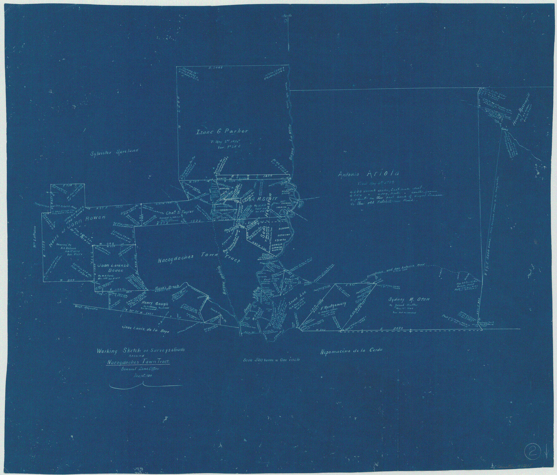
Nacogdoches County Working Sketch 2
-
Map/Doc
71218
-
Collection
General Map Collection
-
Object Dates
12/10/1904 (Creation Date)
-
Counties
Nacogdoches
-
Subjects
Surveying Working Sketch
-
Height x Width
20.5 x 24.1 inches
52.1 x 61.2 cm
-
Scale
1" = 500 varas
Part of: General Map Collection
Harrison County Working Sketch 24

Print $20.00
- Digital $50.00
Harrison County Working Sketch 24
1983
Size 38.0 x 41.3 inches
Map/Doc 66044
Shelby County Working Sketch 23b

Print $20.00
- Digital $50.00
Shelby County Working Sketch 23b
1983
Size 36.6 x 24.7 inches
Map/Doc 63877
Brazoria County Working Sketch 10

Print $20.00
- Digital $50.00
Brazoria County Working Sketch 10
1935
Size 16.2 x 25.2 inches
Map/Doc 67495
Edwards County Working Sketch 51

Print $20.00
- Digital $50.00
Edwards County Working Sketch 51
1950
Size 21.8 x 22.7 inches
Map/Doc 68927
Hutchinson County Rolled Sketch 40

Print $20.00
- Digital $50.00
Hutchinson County Rolled Sketch 40
1981
Size 25.7 x 37.3 inches
Map/Doc 6304
Reagan County Rolled Sketch 20

Print $20.00
- Digital $50.00
Reagan County Rolled Sketch 20
1948
Size 45.8 x 45.0 inches
Map/Doc 9814
Mills County Working Sketch 19

Print $20.00
- Digital $50.00
Mills County Working Sketch 19
1963
Size 18.6 x 31.2 inches
Map/Doc 71049
Flight Mission No. BRE-1P, Frame 151, Nueces County

Print $20.00
- Digital $50.00
Flight Mission No. BRE-1P, Frame 151, Nueces County
1956
Size 18.7 x 22.5 inches
Map/Doc 86711
Kinney County Rolled Sketch 16

Print $20.00
- Digital $50.00
Kinney County Rolled Sketch 16
1963
Size 37.4 x 44.7 inches
Map/Doc 9355
Map of Matagorda & Carancahua Bays in Jackson, Calhoun & Matagorda Cos. showing subdivision thereof for mineral development

Print $20.00
- Digital $50.00
Map of Matagorda & Carancahua Bays in Jackson, Calhoun & Matagorda Cos. showing subdivision thereof for mineral development
1937
Size 26.4 x 37.1 inches
Map/Doc 2255
Map of Eastland County

Print $20.00
- Digital $50.00
Map of Eastland County
1877
Size 26.5 x 24.6 inches
Map/Doc 4535
Harris County Rolled Sketch WB

Print $20.00
- Digital $50.00
Harris County Rolled Sketch WB
1916
Size 15.5 x 21.1 inches
Map/Doc 6147
You may also like

Presidio County Sketch File 43

Print $10.00
- Digital $50.00
Presidio County Sketch File 43
1913
Size 11.2 x 8.7 inches
Map/Doc 34520
Lamar County Sketch File 1

Print $4.00
- Digital $50.00
Lamar County Sketch File 1
1849
Size 8.0 x 8.2 inches
Map/Doc 29271
A New Map of the Whole Continent of America. Divided into North and South and West Indies, wherein are exactly decribed the United States of North America as well as the Several European Possessions according to the Preliminaries of Peace…

Print $40.00
- Digital $50.00
A New Map of the Whole Continent of America. Divided into North and South and West Indies, wherein are exactly decribed the United States of North America as well as the Several European Possessions according to the Preliminaries of Peace…
Size 22.0 x 48.7 inches
Map/Doc 95136
Flight Mission No. DQN-4K, Frame 5, Calhoun County

Print $20.00
- Digital $50.00
Flight Mission No. DQN-4K, Frame 5, Calhoun County
1953
Size 18.7 x 22.4 inches
Map/Doc 84370
Flight Mission No. DCL-6C, Frame 181, Kenedy County

Print $20.00
- Digital $50.00
Flight Mission No. DCL-6C, Frame 181, Kenedy County
1943
Size 18.5 x 22.2 inches
Map/Doc 85993
Flight Mission No. CRE-1R, Frame 64, Jackson County

Print $20.00
- Digital $50.00
Flight Mission No. CRE-1R, Frame 64, Jackson County
1956
Size 15.9 x 15.9 inches
Map/Doc 85327
Starr County Rolled Sketch 44

Print $20.00
- Digital $50.00
Starr County Rolled Sketch 44
Size 38.0 x 46.0 inches
Map/Doc 9943
Collin County Sketch File 7

Print $40.00
- Digital $50.00
Collin County Sketch File 7
1852
Size 17.3 x 14.0 inches
Map/Doc 18866
Webb County Working Sketch 2

Print $20.00
- Digital $50.00
Webb County Working Sketch 2
1906
Size 11.2 x 12.5 inches
Map/Doc 72367

Hutchinson County

Print $20.00
- Digital $50.00
Hutchinson County
1922
Size 14.8 x 17.9 inches
Map/Doc 92168