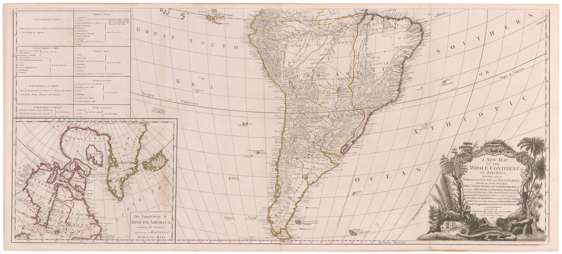
A New Map of the Whole Continent of America. Divided into North and South and West Indies, wherein are exactly decribed the United States of North America as well as the Several European Possessions according to the Preliminaries of Peace…
[South Part]
-
Map/Doc
95136
-
Collection
General Map Collection
-
Object Dates
1786 (Publication Date)
-
People and Organizations
Robert Sayer and John Bennett (Publisher)
Robert Sayer (Publisher)
-
Subjects
North America South America United States
-
Height x Width
22.0 x 48.7 inches
55.9 x 123.7 cm
-
Medium
paper, etching/engraving/lithograph
-
Comments
See 95135 for north part of map and 95137 for a digital composite of both parts.
Related maps
A New Map of the Whole Continent of America. Divided into North and South and West Indies, wherein are exactly decribed the United States of North America as well as the Several European Possessions according to the Preliminaries of Peace…

Print $40.00
- Digital $50.00
A New Map of the Whole Continent of America. Divided into North and South and West Indies, wherein are exactly decribed the United States of North America as well as the Several European Possessions according to the Preliminaries of Peace…
Size 22.0 x 48.3 inches
Map/Doc 95135
A New Map of the Whole Continent of America. Divided into North and South and West Indies, wherein are exactly decribed the United States of North America as well as the Several European Possessions according to the Preliminaries of Peace…

Print $40.00
- Digital $50.00
A New Map of the Whole Continent of America. Divided into North and South and West Indies, wherein are exactly decribed the United States of North America as well as the Several European Possessions according to the Preliminaries of Peace…
Size 42.8 x 48.8 inches
Map/Doc 95137
Part of: General Map Collection
Map of Stephens County

Print $20.00
- Digital $50.00
Map of Stephens County
1897
Size 43.2 x 37.6 inches
Map/Doc 16818
Stephens County Working Sketch 36

Print $20.00
- Digital $50.00
Stephens County Working Sketch 36
1980
Size 35.5 x 32.3 inches
Map/Doc 63979
Tarrant County

Print $20.00
- Digital $50.00
Tarrant County
1873
Size 18.6 x 17.4 inches
Map/Doc 4631
Trace of a copy of the map captured at the battle of Resaca de la Palma

Print $20.00
- Digital $50.00
Trace of a copy of the map captured at the battle of Resaca de la Palma
Size 18.4 x 27.4 inches
Map/Doc 73055
Flight Mission No. BRA-7M, Frame 131, Jefferson County

Print $20.00
- Digital $50.00
Flight Mission No. BRA-7M, Frame 131, Jefferson County
1953
Size 16.2 x 16.0 inches
Map/Doc 85525
Dimmit County Sketch File 15

Print $20.00
- Digital $50.00
Dimmit County Sketch File 15
1883
Size 18.1 x 31.4 inches
Map/Doc 11343
Flight Mission No. BQR-9K, Frame 51, Brazoria County

Print $20.00
- Digital $50.00
Flight Mission No. BQR-9K, Frame 51, Brazoria County
1952
Size 18.9 x 22.4 inches
Map/Doc 84055
Texas compiled from the latest and best authorities

Print $20.00
- Digital $50.00
Texas compiled from the latest and best authorities
1845
Size 12.0 x 14.6 inches
Map/Doc 93922
Dawson County Working Sketch 1

Print $20.00
- Digital $50.00
Dawson County Working Sketch 1
Size 11.1 x 14.1 inches
Map/Doc 68545
San Augustine County Working Sketch 1

Print $3.00
- Digital $50.00
San Augustine County Working Sketch 1
1906
Size 9.1 x 11.3 inches
Map/Doc 63688
Ochiltree County Sketch File A

Print $22.00
- Digital $50.00
Ochiltree County Sketch File A
1888
Size 8.7 x 5.7 inches
Map/Doc 33167
Medina County Rolled Sketch 2

Print $20.00
- Digital $50.00
Medina County Rolled Sketch 2
1936
Size 31.3 x 28.6 inches
Map/Doc 6739
You may also like
Montague County Rolled Sketch 2

Print $20.00
- Digital $50.00
Montague County Rolled Sketch 2
1940
Size 32.5 x 35.5 inches
Map/Doc 9525

Hale County Working Sketch 8

Print $20.00
- Digital $50.00
Hale County Working Sketch 8
1982
Size 22.2 x 34.5 inches
Map/Doc 63328
New City Map of Laredo, Texas

Print $20.00
New City Map of Laredo, Texas
1930
Size 21.7 x 11.3 inches
Map/Doc 76277
Texas Population Distribution in Cities, per the U.S. Census of 1910

Texas Population Distribution in Cities, per the U.S. Census of 1910
2022
Size 11.0 x 8.5 inches
Map/Doc 97092
Gulf Intracoastal Waterway - Tributary Channel to Aransas Pass, Location of Spoil Disposal Areas

Print $20.00
- Digital $50.00
Gulf Intracoastal Waterway - Tributary Channel to Aransas Pass, Location of Spoil Disposal Areas
1961
Size 31.5 x 41.9 inches
Map/Doc 61828
Flight Mission No. DAG-17K, Frame 74, Matagorda County

Print $20.00
- Digital $50.00
Flight Mission No. DAG-17K, Frame 74, Matagorda County
1952
Size 18.5 x 22.3 inches
Map/Doc 86333
Flight Mission No. CGI-1N, Frame 166, Cameron County

Print $20.00
- Digital $50.00
Flight Mission No. CGI-1N, Frame 166, Cameron County
1955
Size 18.5 x 22.2 inches
Map/Doc 84501
Schleicher County Rolled Sketch 24

Print $20.00
- Digital $50.00
Schleicher County Rolled Sketch 24
Size 29.1 x 15.9 inches
Map/Doc 7763

Coryell County Working Sketch 8

Print $20.00
- Digital $50.00
Coryell County Working Sketch 8
1945
Size 36.5 x 33.0 inches
Map/Doc 68215
Photostat of section of hydrographic surveys H-5399, H-4822, H-470

Print $20.00
- Digital $50.00
Photostat of section of hydrographic surveys H-5399, H-4822, H-470
1933
Size 18.4 x 25.8 inches
Map/Doc 61160