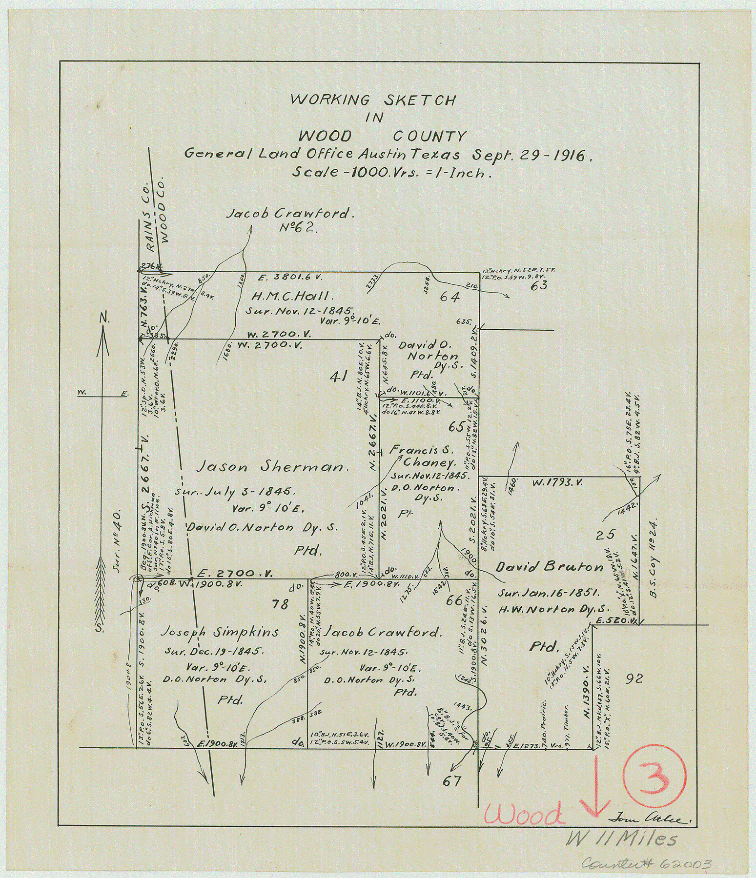
Wood County Working Sketch 3
-
Map/Doc
62003
-
Collection
General Map Collection
-
Object Dates
9/29/1916 (Creation Date)
-
People and Organizations
Tom Atlee (Draftsman)
-
Counties
Wood Rains
-
Subjects
Surveying Working Sketch
-
Height x Width
9.8 x 8.4 inches
24.9 x 21.3 cm
-
Scale
1" = 1000 varas
Part of: General Map Collection
Flight Mission No. BRA-6M, Frame 96, Jefferson County

Print $20.00
- Digital $50.00
Flight Mission No. BRA-6M, Frame 96, Jefferson County
1953
Size 18.5 x 22.3 inches
Map/Doc 85439
Culberson County Sketch File 15

Print $20.00
- Digital $50.00
Culberson County Sketch File 15
1933
Size 30.4 x 24.4 inches
Map/Doc 11267
Ride the Texas Mountain Trail [Verso]
![94165, Ride the Texas Mountain Trail [Verso], General Map Collection](https://historictexasmaps.com/wmedia_w700/maps/94165.tif.jpg)
Ride the Texas Mountain Trail [Verso]
1968
Size 18.3 x 24.4 inches
Map/Doc 94165
Comal County Sketch File 3b

Print $20.00
- Digital $50.00
Comal County Sketch File 3b
1847
Size 12.4 x 16.1 inches
Map/Doc 19003
Gaines County Rolled Sketch 25

Print $20.00
- Digital $50.00
Gaines County Rolled Sketch 25
1977
Size 23.6 x 19.4 inches
Map/Doc 5939
North America in the Age of Dinosaurs

North America in the Age of Dinosaurs
1993
Size 27.4 x 20.8 inches
Map/Doc 96831
Reagan County Working Sketch 29

Print $40.00
- Digital $50.00
Reagan County Working Sketch 29
1963
Size 34.3 x 66.4 inches
Map/Doc 71871
Flight Mission No. DQO-2K, Frame 89, Galveston County

Print $20.00
- Digital $50.00
Flight Mission No. DQO-2K, Frame 89, Galveston County
1952
Size 18.6 x 22.3 inches
Map/Doc 85016
Flight Mission No. DQN-2K, Frame 118, Calhoun County

Print $20.00
- Digital $50.00
Flight Mission No. DQN-2K, Frame 118, Calhoun County
1953
Size 18.5 x 22.2 inches
Map/Doc 84294
Val Verde County Working Sketch 14

Print $20.00
- Digital $50.00
Val Verde County Working Sketch 14
1926
Size 17.2 x 18.9 inches
Map/Doc 72149
Baylor County Boundary File 9

Print $4.00
- Digital $50.00
Baylor County Boundary File 9
Size 11.2 x 8.7 inches
Map/Doc 50407
Newton County Sketch File 27

Print $4.00
- Digital $50.00
Newton County Sketch File 27
Size 13.0 x 8.6 inches
Map/Doc 32411
You may also like
Fractional Township No. 8 South Range No. 15 East of the Indian Meridian, Indian Territory

Print $20.00
- Digital $50.00
Fractional Township No. 8 South Range No. 15 East of the Indian Meridian, Indian Territory
1896
Size 19.1 x 24.3 inches
Map/Doc 75227
Texas State Boundary Line 8

Print $170.00
Texas State Boundary Line 8
2000
Size 11.3 x 8.8 inches
Map/Doc 75054
Flight Mission No. DAH-9M, Frame 83, Orange County

Print $20.00
- Digital $50.00
Flight Mission No. DAH-9M, Frame 83, Orange County
1953
Size 18.5 x 22.3 inches
Map/Doc 86847
Armstrong County Sketch File D

Print $40.00
- Digital $50.00
Armstrong County Sketch File D
Size 16.1 x 21.0 inches
Map/Doc 10857
John B. Slaughter Ranch Situated in Garza County, Texas

Print $20.00
- Digital $50.00
John B. Slaughter Ranch Situated in Garza County, Texas
Size 32.5 x 44.7 inches
Map/Doc 92657
Heydrick's Ownership Map of Concho Co. Tex.

Print $20.00
- Digital $50.00
Heydrick's Ownership Map of Concho Co. Tex.
1919
Size 33.9 x 37.9 inches
Map/Doc 92616
Van Zandt County Rolled Sketch 8

Print $20.00
- Digital $50.00
Van Zandt County Rolled Sketch 8
1948
Size 38.4 x 23.9 inches
Map/Doc 8148
International boundary between U.S. & Mexico in Gulf of Mexico from 12 mile point easterly to 200 mile limit

Print $3.00
- Digital $50.00
International boundary between U.S. & Mexico in Gulf of Mexico from 12 mile point easterly to 200 mile limit
1976
Size 9.6 x 14.8 inches
Map/Doc 1748
Map of Location of the Pecos & Northern Texas Railway from Station 7879+36 to Station 8010+08 = 2.48 Miles through Castro County, Texas

Print $20.00
- Digital $50.00
Map of Location of the Pecos & Northern Texas Railway from Station 7879+36 to Station 8010+08 = 2.48 Miles through Castro County, Texas
1898
Size 14.1 x 25.3 inches
Map/Doc 64060
Jeff Davis County Working Sketch 36

Print $20.00
- Digital $50.00
Jeff Davis County Working Sketch 36
1979
Size 37.2 x 28.8 inches
Map/Doc 66531
Freestone County Working Sketch 27

Print $20.00
- Digital $50.00
Freestone County Working Sketch 27
1986
Size 28.0 x 30.9 inches
Map/Doc 69269
Sutton County Rolled Sketch 43

Print $20.00
- Digital $50.00
Sutton County Rolled Sketch 43
1939
Size 18.7 x 26.8 inches
Map/Doc 7885