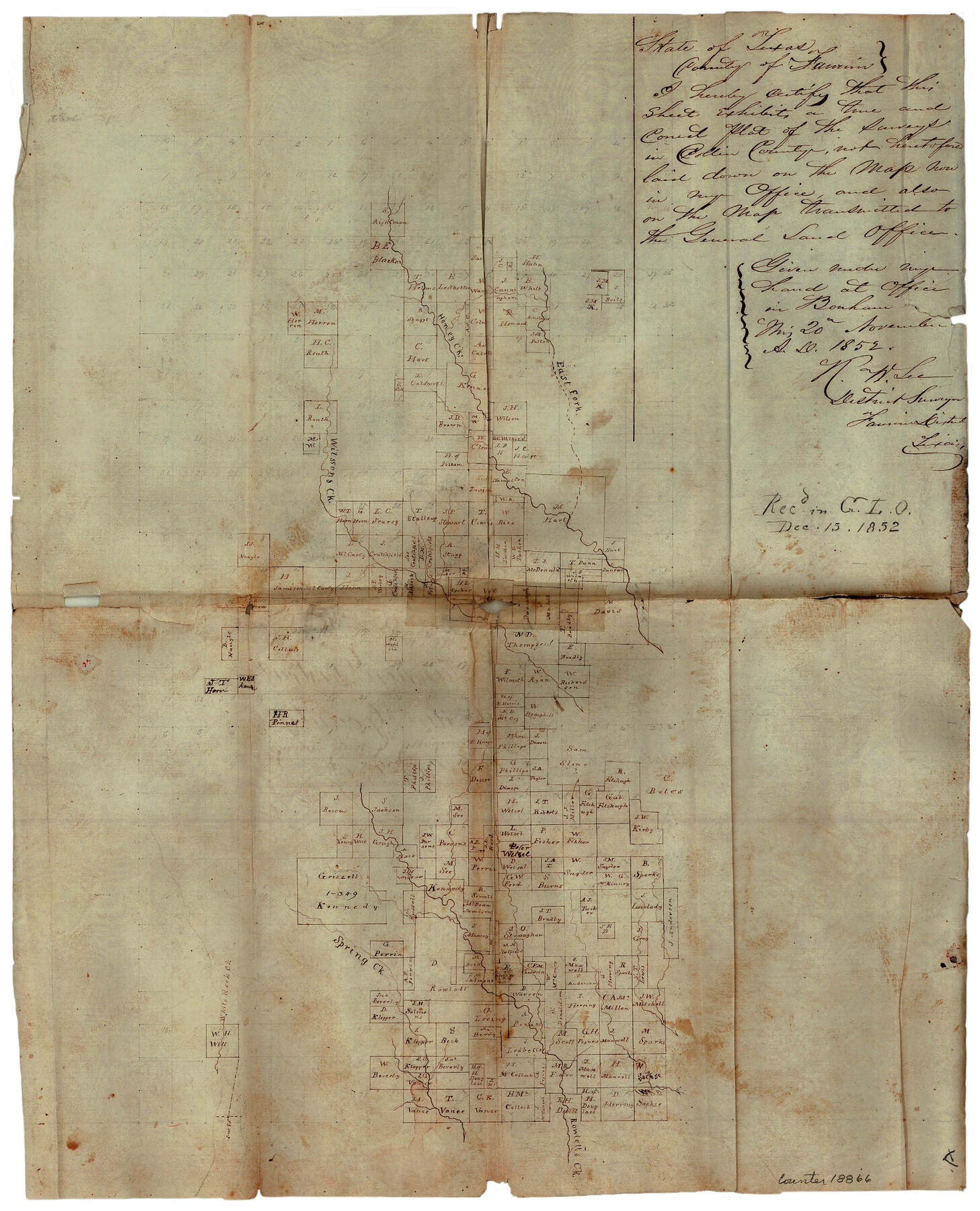
Collin County Sketch File 7
[Sketch of principally colony surveys on Spring, Rowlett's, Wilson's and Honey Creeks and East Fork]
-
Map/Doc
18866
-
Collection
General Map Collection
-
Object Dates
1852/11/20 (Creation Date)
1852/12/15 (File Date)
-
People and Organizations
R.W. Lee (Surveyor/Engineer)
-
Counties
Collin
-
Subjects
Surveying Sketch File
-
Height x Width
17.3 x 14.0 inches
43.9 x 35.6 cm
-
Medium
paper, manuscript
-
Features
Honey Creek
East Fork of Honey Creek
Wilsson's Creek
Spring Creek
Rowlett's Creek
White Rock Creek
Part of: General Map Collection
Collingsworth County Working Sketch 5

Print $20.00
- Digital $50.00
Collingsworth County Working Sketch 5
1973
Size 22.5 x 38.2 inches
Map/Doc 68093
Brewster County Sketch File 18

Print $8.00
- Digital $50.00
Brewster County Sketch File 18
1942
Size 13.8 x 7.6 inches
Map/Doc 15813
Reagan County Sketch File 9

Print $20.00
- Digital $50.00
Reagan County Sketch File 9
1928
Size 27.0 x 22.3 inches
Map/Doc 12216
Flight Mission No. BRA-16M, Frame 180, Jefferson County

Print $20.00
- Digital $50.00
Flight Mission No. BRA-16M, Frame 180, Jefferson County
1953
Size 18.5 x 22.4 inches
Map/Doc 85778
Map of Wharton County

Print $40.00
- Digital $50.00
Map of Wharton County
1895
Size 48.2 x 53.8 inches
Map/Doc 82055
Map of the River Sabine from Logan's Ferry to 32nd degree of north latitude

Print $3.00
- Digital $50.00
Map of the River Sabine from Logan's Ferry to 32nd degree of north latitude
1841
Size 8.7 x 11.1 inches
Map/Doc 94497
Blanco County Sketch File 8

Print $4.00
- Digital $50.00
Blanco County Sketch File 8
Size 8.1 x 12.8 inches
Map/Doc 14584
Right of Way & Track Map, St. Louis, Brownsville & Mexico Ry. operated by St. Louis, Brownsville & Mexico Ry. Co.

Print $40.00
- Digital $50.00
Right of Way & Track Map, St. Louis, Brownsville & Mexico Ry. operated by St. Louis, Brownsville & Mexico Ry. Co.
1919
Size 25.5 x 57.3 inches
Map/Doc 64622
Flight Mission No. CGI-2N, Frame 155, Cameron County

Print $20.00
- Digital $50.00
Flight Mission No. CGI-2N, Frame 155, Cameron County
1954
Size 18.5 x 22.1 inches
Map/Doc 84537
Flight Mission No. CRK-5P, Frame 161, Refugio County

Print $20.00
- Digital $50.00
Flight Mission No. CRK-5P, Frame 161, Refugio County
1956
Size 18.5 x 22.4 inches
Map/Doc 86942
Pecos County Rolled Sketch P

Print $20.00
- Digital $50.00
Pecos County Rolled Sketch P
1885
Size 39.0 x 46.1 inches
Map/Doc 9686
Dickens County Sketch File N

Print $4.00
- Digital $50.00
Dickens County Sketch File N
1903
Size 8.3 x 13.6 inches
Map/Doc 20942
You may also like
Cooke County Working Sketch 3

Print $20.00
- Digital $50.00
Cooke County Working Sketch 3
1926
Size 27.5 x 39.9 inches
Map/Doc 68240
Hale County Boundary File 5

Print $4.00
- Digital $50.00
Hale County Boundary File 5
Size 14.1 x 8.7 inches
Map/Doc 54071
[Right of Way Map, Belton Branch of the M.K.&T. RR.]
![64220, [Right of Way Map, Belton Branch of the M.K.&T. RR.], General Map Collection](https://historictexasmaps.com/wmedia_w700/maps/64220.tif.jpg)
Print $20.00
- Digital $50.00
[Right of Way Map, Belton Branch of the M.K.&T. RR.]
1896
Size 22.2 x 7.4 inches
Map/Doc 64220
Freestone County Sketch File 13

Print $4.00
- Digital $50.00
Freestone County Sketch File 13
1860
Size 8.3 x 8.1 inches
Map/Doc 23063
Gray County Rolled Sketch A

Print $20.00
- Digital $50.00
Gray County Rolled Sketch A
1888
Size 40.4 x 40.8 inches
Map/Doc 9008
Flight Mission No. DIX-6P, Frame 119, Aransas County

Print $20.00
- Digital $50.00
Flight Mission No. DIX-6P, Frame 119, Aransas County
1956
Size 19.1 x 22.7 inches
Map/Doc 83825
Flight Mission No. BRA-6M, Frame 91, Jefferson County

Print $20.00
- Digital $50.00
Flight Mission No. BRA-6M, Frame 91, Jefferson County
1953
Size 18.5 x 22.4 inches
Map/Doc 85434
[Val Verde County]
![63095, [Val Verde County], General Map Collection](https://historictexasmaps.com/wmedia_w700/maps/63095.tif.jpg)
Print $20.00
- Digital $50.00
[Val Verde County]
1898
Size 39.1 x 32.4 inches
Map/Doc 63095
University of Texas System University Lands

Print $20.00
- Digital $50.00
University of Texas System University Lands
1931
Size 23.2 x 17.5 inches
Map/Doc 93241
Fort Bend County Working Sketch 10

Print $20.00
- Digital $50.00
Fort Bend County Working Sketch 10
1934
Size 30.6 x 20.2 inches
Map/Doc 69216
Chambers County Rolled Sketch 7

Print $20.00
- Digital $50.00
Chambers County Rolled Sketch 7
Size 39.8 x 23.1 inches
Map/Doc 8611
Township 2 North, Block 32]
![91211, Township 2 North, Block 32], Twichell Survey Records](https://historictexasmaps.com/wmedia_w700/maps/91211-1.tif.jpg)
Print $2.00
- Digital $50.00
Township 2 North, Block 32]
Size 9.0 x 13.7 inches
Map/Doc 91211