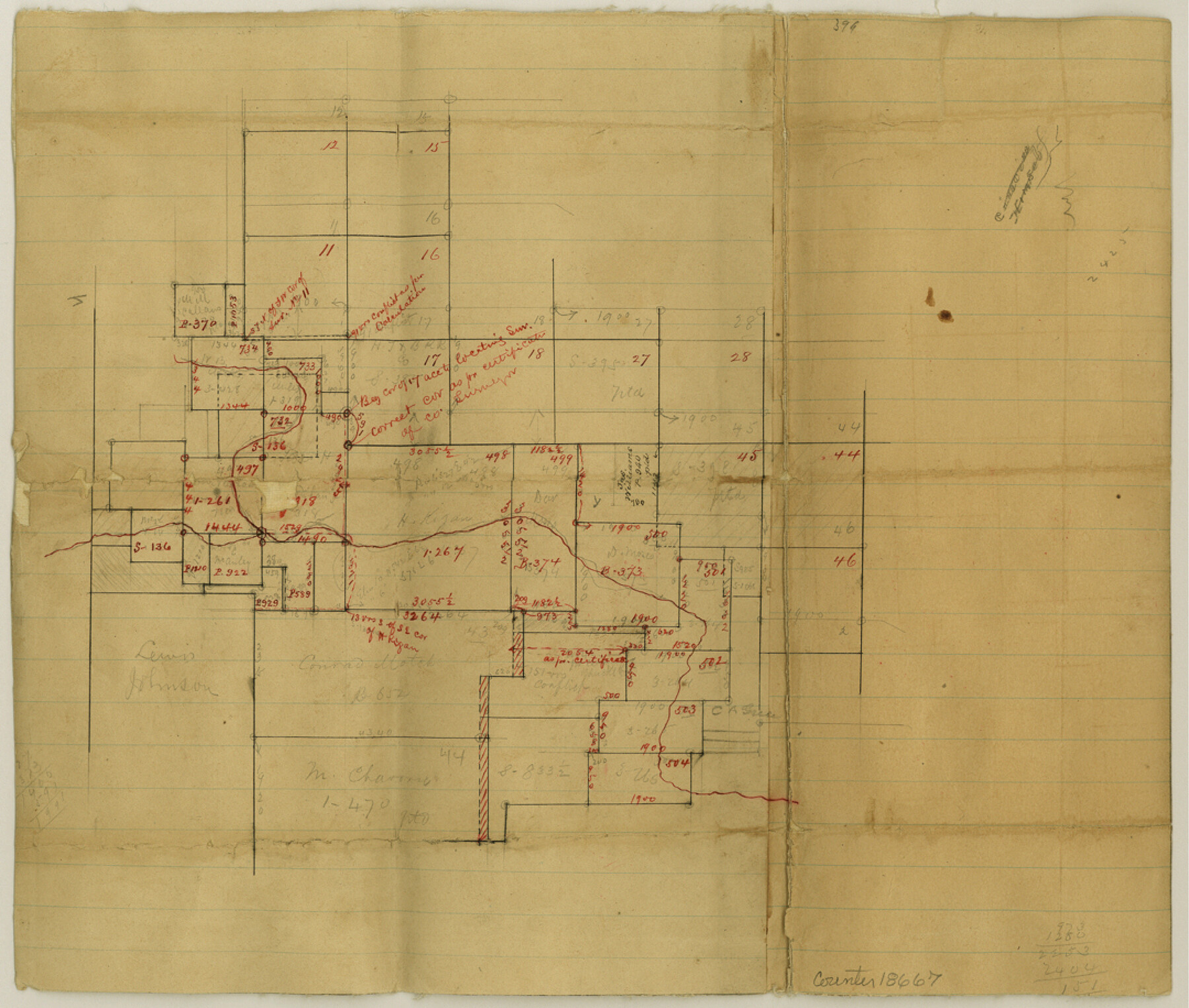
Coleman County Sketch File A2
[Office sketch of surveys around H. Kigan survey no. 498 in the east part of Coleman County and west part of Brown County]
-
Map/Doc
18667
-
Collection
General Map Collection
-
Object Dates
1879/7/29 (File Date)
1879/7/29 (Creation Date)
-
Counties
Coleman Brown
-
Subjects
Surveying Sketch File
-
Height x Width
9.2 x 10.8 inches
23.4 x 27.4 cm
-
Medium
paper, manuscript
Part of: General Map Collection
Intracoastal Waterway in Texas - Corpus Christi to Point Isabel including Arroyo Colorado to Mo. Pac. R.R. Bridge Near Harlingen

Print $20.00
- Digital $50.00
Intracoastal Waterway in Texas - Corpus Christi to Point Isabel including Arroyo Colorado to Mo. Pac. R.R. Bridge Near Harlingen
1934
Size 21.8 x 32.7 inches
Map/Doc 61885
Crockett County

Print $40.00
- Digital $50.00
Crockett County
1882
Size 57.2 x 38.3 inches
Map/Doc 88864
Surveys made on La Parita, March 1847

Print $2.00
- Digital $50.00
Surveys made on La Parita, March 1847
1847
Size 10.1 x 7.5 inches
Map/Doc 222
Frio County Working Sketch 1

Print $20.00
- Digital $50.00
Frio County Working Sketch 1
1906
Size 19.0 x 23.2 inches
Map/Doc 69275
Dawson County Boundary File 3 (2)

Print $40.00
- Digital $50.00
Dawson County Boundary File 3 (2)
Size 13.2 x 33.5 inches
Map/Doc 52367
Crockett County Sketch File 57

Print $22.00
- Digital $50.00
Crockett County Sketch File 57
Size 12.2 x 8.9 inches
Map/Doc 19832
Flight Mission No. BRA-9M, Frame 63, Jefferson County

Print $20.00
- Digital $50.00
Flight Mission No. BRA-9M, Frame 63, Jefferson County
1953
Size 18.6 x 22.4 inches
Map/Doc 85646
Crockett County Sketch File 58

Print $20.00
- Digital $50.00
Crockett County Sketch File 58
1932
Size 17.9 x 23.2 inches
Map/Doc 11226
La Salle County Working Sketch 21

Print $20.00
- Digital $50.00
La Salle County Working Sketch 21
1942
Size 25.4 x 24.0 inches
Map/Doc 70322
Plan C, Part 3rd This plan represents that portion of the boundary between the Republic of Texas and the United States included between the 72nd mile mound and Red River

Print $20.00
- Digital $50.00
Plan C, Part 3rd This plan represents that portion of the boundary between the Republic of Texas and the United States included between the 72nd mile mound and Red River
1842
Size 19.3 x 27.2 inches
Map/Doc 65414
[Maps of surveys in Reeves & Culberson Cos]
![61142, [Maps of surveys in Reeves & Culberson Cos], General Map Collection](https://historictexasmaps.com/wmedia_w700/maps/61142.tif.jpg)
Print $20.00
- Digital $50.00
[Maps of surveys in Reeves & Culberson Cos]
1937
Size 30.6 x 24.8 inches
Map/Doc 61142
Refugio County Rolled Sketch 8

Print $40.00
- Digital $50.00
Refugio County Rolled Sketch 8
1954
Size 53.9 x 46.7 inches
Map/Doc 9860
You may also like
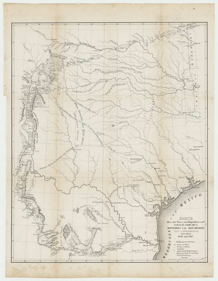
Karte über eine Reise von Independence nach Santa Fé, Chihuahua, Monterey und Matamoros von A. Wislizenus, in den Jahren 1846 und 1847
Print $20.00
- Digital $50.00
Karte über eine Reise von Independence nach Santa Fé, Chihuahua, Monterey und Matamoros von A. Wislizenus, in den Jahren 1846 und 1847
1850
Size 22.6 x 17.5 inches
Map/Doc 97528
No. 2 Chart of Corpus Christi Pass, Texas

Print $20.00
- Digital $50.00
No. 2 Chart of Corpus Christi Pass, Texas
1878
Size 18.4 x 27.3 inches
Map/Doc 73016
Flight Mission No. BQR-20K, Frame 8, Brazoria County

Print $20.00
- Digital $50.00
Flight Mission No. BQR-20K, Frame 8, Brazoria County
1952
Size 18.6 x 22.3 inches
Map/Doc 84110
Erath County Working Sketch 24

Print $20.00
- Digital $50.00
Erath County Working Sketch 24
1967
Size 41.5 x 39.3 inches
Map/Doc 69105
[Map of Lt. Brulls scout in Haskell, Throckmorton, Jones and Shackelford Counties]
![65399, [Map of Lt. Brulls scout in Haskell, Throckmorton, Jones and Shackelford Counties], General Map Collection](https://historictexasmaps.com/wmedia_w700/maps/65399-1.tif.jpg)
Print $3.00
- Digital $50.00
[Map of Lt. Brulls scout in Haskell, Throckmorton, Jones and Shackelford Counties]
1873
Size 10.1 x 11.9 inches
Map/Doc 65399
Hudspeth County Working Sketch 3

Print $20.00
- Digital $50.00
Hudspeth County Working Sketch 3
1913
Size 20.4 x 17.2 inches
Map/Doc 66284
Upton County Boundary File 2

Print $6.00
- Digital $50.00
Upton County Boundary File 2
Size 14.4 x 8.9 inches
Map/Doc 59517
Edwards County Working Sketch 44

Print $20.00
- Digital $50.00
Edwards County Working Sketch 44
1950
Size 44.1 x 26.0 inches
Map/Doc 68920
Milam County Working Sketch 16

Print $20.00
- Digital $50.00
Milam County Working Sketch 16
Size 30.4 x 36.2 inches
Map/Doc 71028
Motley County Boundary File 1a

Print $8.00
- Digital $50.00
Motley County Boundary File 1a
Size 11.2 x 8.5 inches
Map/Doc 57501
Bowie County Working Sketch 22

Print $40.00
- Digital $50.00
Bowie County Working Sketch 22
1968
Size 49.0 x 37.8 inches
Map/Doc 67426
Cochran and Yoakum Counties, Texas

Print $20.00
- Digital $50.00
Cochran and Yoakum Counties, Texas
1945
Size 24.4 x 17.4 inches
Map/Doc 92513