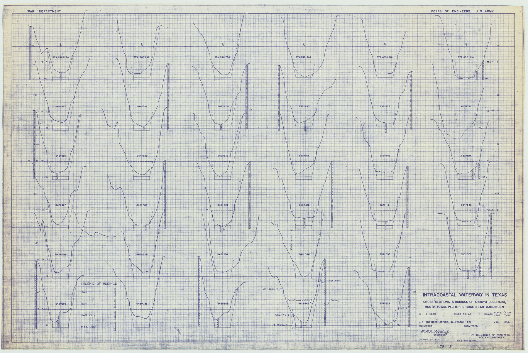
Intracoastal Waterway in Texas - Corpus Christi to Point Isabel including Arroyo Colorado to Mo. Pac. R.R. Bridge Near Harlingen
- 
                          Map/Doc61885
- 
                            CollectionGeneral Map Collection
- 
                            Object Dates1934 (Creation Date)
- 
                            SubjectsIntracoastal Waterways
- 
                            Height x Width21.8 x 32.7 inches55.4 x 83.1 cm
Part of: General Map Collection
            Terry County Rolled Sketch 10


                                            Print $20.00                    
                                             -                         Digital $50.00                                    
                Terry County Rolled Sketch 10
2001
Size 25.2 x 23.8 inches
                                Map/Doc 76414
            
            Baylor County Sketch File 26


                                            Print $22.00                    
                                             -                         Digital $50.00                                    
                Baylor County Sketch File 26
Size 14.6 x 9.0 inches
                                Map/Doc 14215
            
            Culberson County Rolled Sketch 10


                                            Print $20.00                    
                                             -                         Digital $50.00                                    
                Culberson County Rolled Sketch 10
1893
Size 16.4 x 25.9 inches
                                Map/Doc 5647
            
            Maps of Gulf Intracoastal Waterway, Texas - Sabine River to the Rio Grande and connecting waterways including ship channels


                                            Print $20.00                    
                                             -                         Digital $50.00                                    
                Maps of Gulf Intracoastal Waterway, Texas - Sabine River to the Rio Grande and connecting waterways including ship channels
1966
Size 14.6 x 22.3 inches
                                Map/Doc 61950
            
            Culberson County Working Sketch 14


                                            Print $20.00                    
                                             -                         Digital $50.00                                    
                Culberson County Working Sketch 14
1923
Size 17.9 x 19.2 inches
                                Map/Doc 68466
            
            Henderson County Working Sketch 41


                                            Print $20.00                    
                                             -                         Digital $50.00                                    
                Henderson County Working Sketch 41
1985
Size 28.8 x 17.0 inches
                                Map/Doc 66174
            
            Flight Mission No. CLL-3N, Frame 14, Willacy County


                                            Print $20.00                    
                                             -                         Digital $50.00                                    
                Flight Mission No. CLL-3N, Frame 14, Willacy County
1954
Size 18.4 x 22.2 inches
                                Map/Doc 87080
            
            University Land Field Notes for Blocks 39, 41, 42, 44, 45, 46, 47, 50, and 51 in Crockett County, Blocks 38 and 40 in Crockett and Irion Counties, and Blocks 48 and 49 in Crockett and Reagan Counties, and Block 43 in Crockett, Irion, and Reagan Counties


            University Land Field Notes for Blocks 39, 41, 42, 44, 45, 46, 47, 50, and 51 in Crockett County, Blocks 38 and 40 in Crockett and Irion Counties, and Blocks 48 and 49 in Crockett and Reagan Counties, and Block 43 in Crockett, Irion, and Reagan Counties
Map/Doc 81718
            
            Angelina County Working Sketch 38


                                            Print $20.00                    
                                             -                         Digital $50.00                                    
                Angelina County Working Sketch 38
1958
Size 26.4 x 33.0 inches
                                Map/Doc 67121
            
            Van Zandt County Sketch File 47


                                            Print $7.00                    
                                             -                         Digital $50.00                                    
                Van Zandt County Sketch File 47
Size 10.0 x 8.1 inches
                                Map/Doc 39504
            
            Angelina County Boundary File 1


                                            Print $16.00                    
                                             -                         Digital $50.00                                    
                Angelina County Boundary File 1
Size 12.9 x 8.3 inches
                                Map/Doc 49765
            
            Callahan County Sketch File 9


                                            Print $40.00                    
                                             -                         Digital $50.00                                    
                Callahan County Sketch File 9
1880
Size 16.8 x 14.3 inches
                                Map/Doc 35871
            You may also like
            [Sketch for Mineral Application 16700 - Pecos River Bed]
            
                                    ![2810, [Sketch for Mineral Application 16700 - Pecos River Bed], General Map Collection](https://historictexasmaps.com/wmedia_w700/maps/2810.tif.jpg) 


    ![2810, [Sketch for Mineral Application 16700 - Pecos River Bed], General Map Collection](https://historictexasmaps.com/wmedia_w700/maps/2810.tif.jpg) 
                                
            
                                            Print $20.00                    
                                             -                         Digital $50.00                                    
                [Sketch for Mineral Application 16700 - Pecos River Bed]
1927
Size 17.0 x 36.1 inches
                                Map/Doc 2810
            
            Hudspeth County Working Sketch 61


                                            Print $20.00                    
                                             -                         Digital $50.00                                    
                Hudspeth County Working Sketch 61
1992
Size 42.8 x 31.2 inches
                                Map/Doc 66346
            
            Johnson County Working Sketch 5


                                            Print $4.00                    
                                             -                         Digital $50.00                                    
                Johnson County Working Sketch 5
1950
Size 25.8 x 22.3 inches
                                Map/Doc 66618
            
            Hudspeth County Working Sketch 33


                                            Print $20.00                    
                                             -                         Digital $50.00                                    
                Hudspeth County Working Sketch 33
1977
Size 26.8 x 21.4 inches
                                Map/Doc 66318
            
            Galveston Bay and Approaches


                                            Print $20.00                    
                                             -                         Digital $50.00                                    
                Galveston Bay and Approaches
1933
Size 46.0 x 34.9 inches
                                Map/Doc 69874
            
            Liberty County Working Sketch 41


                                            Print $20.00                    
                                             -                         Digital $50.00                                    
                Liberty County Working Sketch 41
1953
Size 21.4 x 20.8 inches
                                Map/Doc 70500
            
            [Galveston, Harrisburg & San Antonio Railroad from Cuero to Stockdale]
            
                                    ![64198, [Galveston, Harrisburg & San Antonio Railroad from Cuero to Stockdale], General Map Collection](https://historictexasmaps.com/wmedia_w700/maps/64198.tif.jpg) 


    ![64198, [Galveston, Harrisburg & San Antonio Railroad from Cuero to Stockdale], General Map Collection](https://historictexasmaps.com/wmedia_w700/maps/64198.tif.jpg) 
                                
            
                                            Print $20.00                    
                                             -                         Digital $50.00                                    
                [Galveston, Harrisburg & San Antonio Railroad from Cuero to Stockdale]
1907
Size 13.9 x 34.1 inches
                                Map/Doc 64198
            
            Duval County Rolled Sketch 29


                                            Print $20.00                    
                                             -                         Digital $50.00                                    
                Duval County Rolled Sketch 29
1947
Size 16.2 x 25.8 inches
                                Map/Doc 5746
            
            Howard T. Trigg's Official Map of Amarillo


                                            Print $40.00                    
                                             -                         Digital $50.00                                    
                Howard T. Trigg's Official Map of Amarillo
Size 79.1 x 54.0 inches
                                Map/Doc 93196
            
            General Highway Map, Bosque County, Texas


                                            Print $20.00                    
                                    
                General Highway Map, Bosque County, Texas
1961
Size 24.7 x 18.1 inches
                                Map/Doc 79378
             
                         
                                