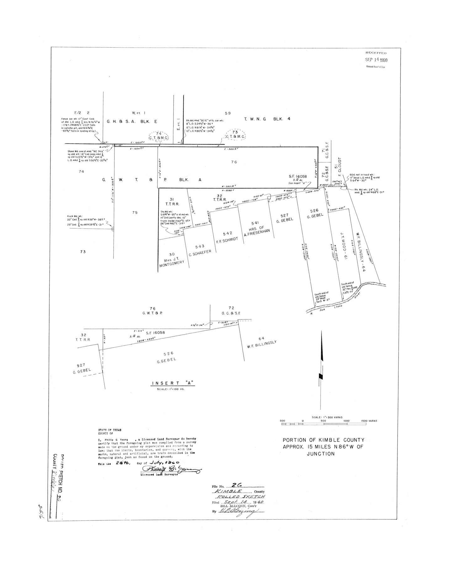
Kimble County Rolled Sketch 26
Portion of Kimble County [west of Junction]
- 
                          Map/Doc6516
- 
                            CollectionGeneral Map Collection
- 
                            Object Dates1960/7/28 (Creation Date)1960/9/14 (File Date)
- 
                            People and OrganizationsPhillip G. Young (Surveyor/Engineer)
- 
                            CountiesKimble
- 
                            SubjectsSurveying Rolled Sketch
- 
                            Height x Width26.4 x 21.6 inches67.1 x 54.9 cm
- 
                            Scale1" = 500 varas
Related maps
            Kimble County Sketch File 33


                                            Print $10.00                    
                                             -                         Digital $50.00                                    
                Kimble County Sketch File 33
1960
Size 11.2 x 8.8 inches
                                Map/Doc 28977
            Part of: General Map Collection
            Brazoria County Sketch File 12a


                                            Print $4.00                    
                                             -                         Digital $50.00                                    
                Brazoria County Sketch File 12a
1886
Size 11.2 x 8.5 inches
                                Map/Doc 14971
            
            Young County Sketch File 21


                                            Print $20.00                    
                                             -                         Digital $50.00                                    
                Young County Sketch File 21
1954
Size 19.0 x 23.0 inches
                                Map/Doc 12715
            
            Eastland County Working Sketch 42


                                            Print $20.00                    
                                             -                         Digital $50.00                                    
                Eastland County Working Sketch 42
1979
Size 43.5 x 35.0 inches
                                Map/Doc 68823
            
            Hamilton County Sketch File 6


                                            Print $6.00                    
                                             -                         Digital $50.00                                    
                Hamilton County Sketch File 6
Size 15.7 x 10.6 inches
                                Map/Doc 24910
            
            Jack County Rolled Sketch 3A


                                            Print $20.00                    
                                             -                         Digital $50.00                                    
                Jack County Rolled Sketch 3A
1985
Size 34.9 x 32.2 inches
                                Map/Doc 6334
            
            Dimmit County Working Sketch Graphic Index - sheet A


                                            Print $40.00                    
                                             -                         Digital $50.00                                    
                Dimmit County Working Sketch Graphic Index - sheet A
1976
Size 42.0 x 49.7 inches
                                Map/Doc 76524
            
            Bosque County Sketch File 32


                                            Print $42.00                    
                                             -                         Digital $50.00                                    
                Bosque County Sketch File 32
1944
Size 19.6 x 18.6 inches
                                Map/Doc 10938
            
            Bowie County Working Sketch 23


                                            Print $20.00                    
                                             -                         Digital $50.00                                    
                Bowie County Working Sketch 23
1969
Size 25.5 x 29.7 inches
                                Map/Doc 67427
            
            Harris County Working Sketch 5


                                            Print $20.00                    
                                             -                         Digital $50.00                                    
                Harris County Working Sketch 5
Size 35.1 x 28.0 inches
                                Map/Doc 65897
            
            Map of the Republic of Texas Shewing [sic] its division into Counties and Latest Improvements to 1837
            
                                    ![476, Map of the Republic of Texas Shewing [sic] its division into Counties and Latest Improvements to 1837, General Map Collection](https://historictexasmaps.com/wmedia_w700/maps/476-1.tif.jpg) 


    ![476, Map of the Republic of Texas Shewing [sic] its division into Counties and Latest Improvements to 1837, General Map Collection](https://historictexasmaps.com/wmedia_w700/maps/476-1.tif.jpg) 
                                
            
                                            Print $20.00                    
                                             -                         Digital $50.00                                    
                Map of the Republic of Texas Shewing [sic] its division into Counties and Latest Improvements to 1837
1837
Size 28.2 x 23.0 inches
                                Map/Doc 476
            
            The Cotton Kingdom: a Traveller's Observations on Cotton and Slavery in the American Slave States


            The Cotton Kingdom: a Traveller's Observations on Cotton and Slavery in the American Slave States
Map/Doc 96571
            
            Grayson County Sketch File 18


                                            Print $6.00                    
                                             -                         Digital $50.00                                    
                Grayson County Sketch File 18
1859
Size 12.2 x 7.9 inches
                                Map/Doc 24487
            You may also like
            Map showing surveys in Blocks 45, 3, R & 5T


                                            Print $20.00                    
                                             -                         Digital $50.00                                    
                Map showing surveys in Blocks 45, 3, R & 5T
1913
Size 30.2 x 37.5 inches
                                Map/Doc 496
            
            Garza County Sketch File 20


                                            Print $20.00                    
                                             -                         Digital $50.00                                    
                Garza County Sketch File 20
1905
Size 8.7 x 7.8 inches
                                Map/Doc 24068
            
            Kenedy County Working Sketch 3


                                            Print $20.00                    
                                             -                         Digital $50.00                                    
                Kenedy County Working Sketch 3
1903
Size 30.3 x 38.4 inches
                                Map/Doc 70005
            
            Chambers County NRC Article 33.136 Sketch 6


                                            Print $58.00                    
                                             -                         Digital $50.00                                    
                Chambers County NRC Article 33.136 Sketch 6
2007
Size 11.0 x 8.5 inches
                                Map/Doc 88802
            
            Eastland County Working Sketch 57


                                            Print $20.00                    
                                             -                         Digital $50.00                                    
                Eastland County Working Sketch 57
1985
Size 21.7 x 21.8 inches
                                Map/Doc 68838
            
            Comanche County Sketch File 22a


                                            Print $2.00                    
                                             -                         Digital $50.00                                    
                Comanche County Sketch File 22a
Size 8.2 x 7.6 inches
                                Map/Doc 19108
            
            Flight Mission No. CGI-2N, Frame 154, Cameron County


                                            Print $20.00                    
                                             -                         Digital $50.00                                    
                Flight Mission No. CGI-2N, Frame 154, Cameron County
1954
Size 18.6 x 19.0 inches
                                Map/Doc 84536
            
            Flight Mission No. DCL-7C, Frame 54, Kenedy County


                                            Print $20.00                    
                                             -                         Digital $50.00                                    
                Flight Mission No. DCL-7C, Frame 54, Kenedy County
1943
Size 15.3 x 15.3 inches
                                Map/Doc 86042
            
            Val Verde County Sketch File Z21


                                            Print $20.00                    
                                             -                         Digital $50.00                                    
                Val Verde County Sketch File Z21
Size 18.3 x 17.3 inches
                                Map/Doc 12560
            
            [Area between G. C. & S. F. RR. Co. Block 194 and Runnels County School Land Survey No. 3]
            
                                    ![91635, [Area between G. C. & S. F. RR. Co. Block 194 and Runnels County School Land Survey No. 3], Twichell Survey Records](https://historictexasmaps.com/wmedia_w700/maps/91635-1.tif.jpg) 


    ![91635, [Area between G. C. & S. F. RR. Co. Block 194 and Runnels County School Land Survey No. 3], Twichell Survey Records](https://historictexasmaps.com/wmedia_w700/maps/91635-1.tif.jpg) 
                                
            
                                            Print $3.00                    
                                             -                         Digital $50.00                                    
                [Area between G. C. & S. F. RR. Co. Block 194 and Runnels County School Land Survey No. 3]
1926
Size 16.6 x 11.9 inches
                                Map/Doc 91635
            
            Montgomery County Sketch File 6b


                                            Print $40.00                    
                                             -                         Digital $50.00                                    
                Montgomery County Sketch File 6b
Size 12.8 x 16.2 inches
                                Map/Doc 31783
             
                        