Kimble County Sketch File 33
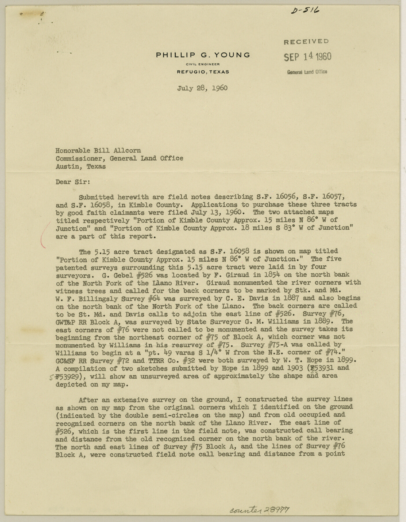
[Surveyor's report regarding SF-16056, SF-16057 and SF-16058]
-
Map/Doc
28977
-
Collection
General Map Collection
-
Object Dates
7/28/1960 (Creation Date)
9/14/1960 (File Date)
-
People and Organizations
Phillip G. Young (Surveyor/Engineer)
F. Giraud (Surveyor/Engineer)
C.E. Davis (Surveyor/Engineer)
G.M. Williams (Surveyor/Engineer)
W.T. Hope (Surveyor/Engineer)
Frank Vickrey (Surveyor/Engineer)
-
Counties
Kimble
-
Subjects
Surveying Sketch File
-
Height x Width
11.2 x 8.8 inches
28.5 x 22.4 cm
-
Medium
paper, print
-
Comments
See Kimble County Rolled Sketches 25 (6515) and 26 (6516).
-
Features
North Fork of Llano River
Maynard Creek
Chestnut Creek
Related maps
Kimble County Rolled Sketch 25

Print $20.00
- Digital $50.00
Kimble County Rolled Sketch 25
1960
Size 26.1 x 28.3 inches
Map/Doc 6515
Kimble County Rolled Sketch 26

Print $20.00
- Digital $50.00
Kimble County Rolled Sketch 26
1960
Size 26.4 x 21.6 inches
Map/Doc 6516
Part of: General Map Collection
Presidio County Working Sketch 130

Print $20.00
- Digital $50.00
Presidio County Working Sketch 130
1989
Size 22.1 x 43.1 inches
Map/Doc 71808
Flight Mission No. DCL-6C, Frame 67, Kenedy County

Print $20.00
- Digital $50.00
Flight Mission No. DCL-6C, Frame 67, Kenedy County
1943
Size 18.6 x 22.2 inches
Map/Doc 85909
Flight Mission No. DQO-7K, Frame 107, Galveston County

Print $20.00
- Digital $50.00
Flight Mission No. DQO-7K, Frame 107, Galveston County
1952
Size 18.6 x 22.6 inches
Map/Doc 85122
Hardeman County Aerial Photograph Index Sheet 2

Print $20.00
- Digital $50.00
Hardeman County Aerial Photograph Index Sheet 2
1950
Size 20.3 x 16.9 inches
Map/Doc 83698
Galveston County Rolled Sketch 45B

Print $20.00
- Digital $50.00
Galveston County Rolled Sketch 45B
1995
Size 19.8 x 29.7 inches
Map/Doc 5980
Young County Working Sketch 13

Print $20.00
- Digital $50.00
Young County Working Sketch 13
1938
Size 46.0 x 40.4 inches
Map/Doc 62036
Schleicher County Working Sketch 10

Print $20.00
- Digital $50.00
Schleicher County Working Sketch 10
1923
Size 18.3 x 16.4 inches
Map/Doc 63812
Shackelford County Rolled Sketch 6

Print $20.00
- Digital $50.00
Shackelford County Rolled Sketch 6
1998
Size 24.1 x 35.9 inches
Map/Doc 7774
Red River County Working Sketch 2

Print $20.00
- Digital $50.00
Red River County Working Sketch 2
1918
Size 26.9 x 21.7 inches
Map/Doc 71985
Randall County

Print $20.00
- Digital $50.00
Randall County
1879
Size 21.4 x 19.2 inches
Map/Doc 3974
Austin County Working Sketch 4

Print $20.00
- Digital $50.00
Austin County Working Sketch 4
1959
Size 29.8 x 34.8 inches
Map/Doc 67245
Aransas County Sketch File 21

Print $2.00
- Digital $50.00
Aransas County Sketch File 21
Size 8.0 x 8.9 inches
Map/Doc 13157
You may also like

Webb County Working Sketch 97

Print $20.00
- Digital $50.00
Webb County Working Sketch 97
1994
Size 27.1 x 30.6 inches
Map/Doc 72464
Garza County Sketch File 15

Print $20.00
- Digital $50.00
Garza County Sketch File 15
1902
Size 16.8 x 14.7 inches
Map/Doc 11545
Dallas County Rolled Sketch 3

Print $40.00
- Digital $50.00
Dallas County Rolled Sketch 3
1953
Size 30.7 x 78.5 inches
Map/Doc 8767

Van Zandt County

Print $20.00
- Digital $50.00
Van Zandt County
1870
Size 22.8 x 21.1 inches
Map/Doc 4638
Baylor County

Print $20.00
- Digital $50.00
Baylor County
1961
Size 42.5 x 34.8 inches
Map/Doc 73077
Competing Transportation Lines between Boston, New York, Philadelphia, Baltimore, and the South Atlantic and Gulf States

Print $20.00
- Digital $50.00
Competing Transportation Lines between Boston, New York, Philadelphia, Baltimore, and the South Atlantic and Gulf States
1881
Size 15.1 x 17.8 inches
Map/Doc 95907
Marion County Working Sketch 22

Print $20.00
- Digital $50.00
Marion County Working Sketch 22
1960
Size 34.3 x 27.5 inches
Map/Doc 70798
Map showing the Kansas & Gulf Short Line R.R. and the Texas & St. Louis R'y with its branches, extensions and connections.

Print $20.00
Map showing the Kansas & Gulf Short Line R.R. and the Texas & St. Louis R'y with its branches, extensions and connections.
1881
Size 30.3 x 30.9 inches
Map/Doc 93608
Flight Mission No. BQR-4K, Frame 62, Brazoria County

Print $20.00
- Digital $50.00
Flight Mission No. BQR-4K, Frame 62, Brazoria County
1952
Size 18.9 x 22.5 inches
Map/Doc 83995
Flight Mission No. CUI-1H, Frame 95, Milam County

Print $20.00
- Digital $50.00
Flight Mission No. CUI-1H, Frame 95, Milam County
1951
Size 18.4 x 22.2 inches
Map/Doc 86603