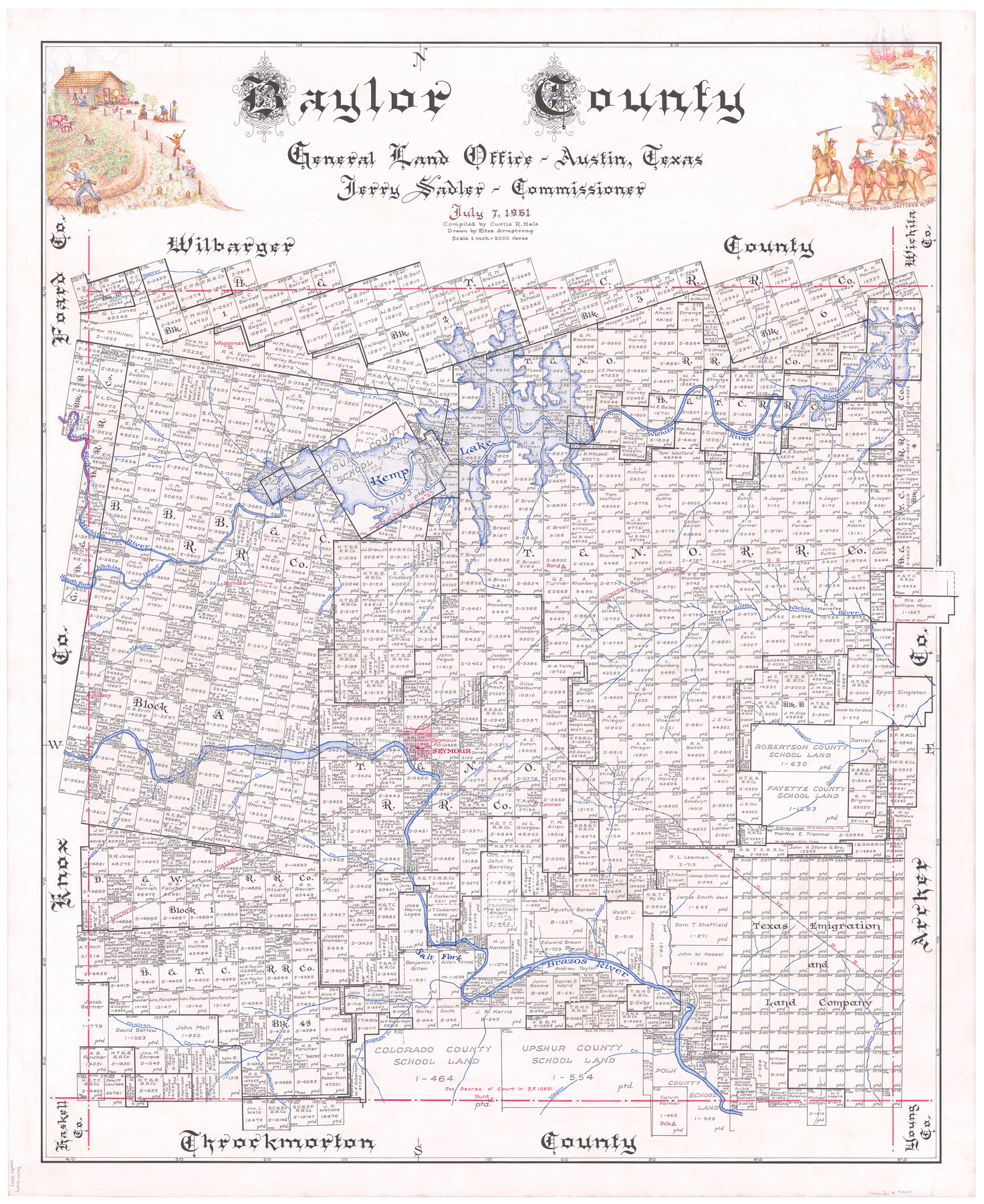
Baylor County
-
Map/Doc
73077
-
Collection
General Map Collection
-
Object Dates
1961/7/7 (Creation Date)
-
People and Organizations
Texas General Land Office (Publisher)
Jerry Sadler (GLO Commissioner)
Curtis R. Hale (Compiler)
Eltea Armstrong (Draftsman)
-
Counties
Baylor
-
Subjects
County
-
Height x Width
42.5 x 34.8 inches
108.0 x 88.4 cm
-
Features
GT&W
Seymour
Daggett Creek
Goodwin Creek
Rock Creek
Little Rock Creek
Ednas Creek
Lake Creek
Cache Creek
Soap Creek
Deep Creek
Salt Fork of Brazos River
Mexican Creek
Grayback Creek
Spring Creek
Wagon Creek
Antelope Creek
Miller Creek
McAdam Creek
Diversion Lake
Haggarts Creek
Fish Creek
Crooked Creek
North Fork of Wichita River
Kemp Lake
Wichita River
Santa Anna Creek
Beaver Creek
South Fork of Wichita River
New Ports Creek
Pony Creek
WVRR
Little Wichita River
Gray Creek
Maudes Creek
-
URLs
https://medium.com/save-texas-history/baylor-county-1961-5b35be5f9999#.dkpi8czb4
Part of: General Map Collection
Hays County Sketch File 30

Print $12.00
- Digital $50.00
Hays County Sketch File 30
1938
Size 14.3 x 9.0 inches
Map/Doc 26255
Brazoria County Sketch File 47

Print $10.00
- Digital $50.00
Brazoria County Sketch File 47
Size 14.3 x 8.9 inches
Map/Doc 15106
Flight Mission No. DQN-5K, Frame 60, Calhoun County

Print $20.00
- Digital $50.00
Flight Mission No. DQN-5K, Frame 60, Calhoun County
1953
Size 15.5 x 15.4 inches
Map/Doc 84403
Reeves County Working Sketch 2

Print $20.00
- Digital $50.00
Reeves County Working Sketch 2
1903
Size 22.6 x 42.4 inches
Map/Doc 63444
Gregg County Sketch File 6

Print $10.00
- Digital $50.00
Gregg County Sketch File 6
1931
Size 11.2 x 8.8 inches
Map/Doc 24577
Reeves County Working Sketch 4

Print $20.00
- Digital $50.00
Reeves County Working Sketch 4
1922
Size 32.5 x 33.1 inches
Map/Doc 63446
Flight Mission No. BRE-1P, Frame 53, Nueces County

Print $20.00
- Digital $50.00
Flight Mission No. BRE-1P, Frame 53, Nueces County
1956
Size 18.5 x 22.4 inches
Map/Doc 86642

Culberson County Working Sketch 78

Print $40.00
- Digital $50.00
Culberson County Working Sketch 78
1976
Size 51.8 x 36.2 inches
Map/Doc 68532
Map of Travis County

Print $40.00
- Digital $50.00
Map of Travis County
1895
Size 48.8 x 54.1 inches
Map/Doc 82083
Jack County Rolled Sketch 3

Print $20.00
- Digital $50.00
Jack County Rolled Sketch 3
1985
Size 30.3 x 27.5 inches
Map/Doc 6333
El Paso County Boundary File 4

Print $12.00
- Digital $50.00
El Paso County Boundary File 4
Size 13.5 x 8.6 inches
Map/Doc 53038
You may also like
Nueces County Rolled Sketch 126

Print $20.00
- Digital $50.00
Nueces County Rolled Sketch 126
1998
Size 24.5 x 36.8 inches
Map/Doc 7161
Events of the Texas Revolution

Events of the Texas Revolution
2023
Size 11.0 x 8.5 inches
Map/Doc 97189
Parker County Rolled Sketch 6

Print $20.00
- Digital $50.00
Parker County Rolled Sketch 6
Size 28.3 x 34.1 inches
Map/Doc 7207
Montgomery County Rolled Sketch 26A

Print $20.00
- Digital $50.00
Montgomery County Rolled Sketch 26A
1941
Size 26.9 x 36.8 inches
Map/Doc 6808
General Highway Map, Runnels County, Texas

Print $20.00
General Highway Map, Runnels County, Texas
1940
Size 24.7 x 18.3 inches
Map/Doc 79231
Dimmit County Boundary File 1

Print $8.00
- Digital $50.00
Dimmit County Boundary File 1
Size 12.9 x 7.9 inches
Map/Doc 52560
Flight Mission No. CRC-3R, Frame 103, Chambers County

Print $20.00
- Digital $50.00
Flight Mission No. CRC-3R, Frame 103, Chambers County
1956
Size 18.7 x 22.4 inches
Map/Doc 84841
Hudspeth County Rolled Sketch 77

Print $20.00
- Digital $50.00
Hudspeth County Rolled Sketch 77
Size 25.2 x 38.0 inches
Map/Doc 6265
Aransas County Working Sketch 14

Print $20.00
- Digital $50.00
Aransas County Working Sketch 14
1951
Size 22.5 x 22.3 inches
Map/Doc 67181
Montgomery County Rolled Sketch 51

Print $20.00
- Digital $50.00
Montgomery County Rolled Sketch 51
2021
Map/Doc 97369
Plat of South 1/2 of Colorado River Channel in McCulloch Co., Texas from Concho County line down river 34 mile 315 varas

Print $40.00
- Digital $50.00
Plat of South 1/2 of Colorado River Channel in McCulloch Co., Texas from Concho County line down river 34 mile 315 varas
1918
Size 41.1 x 144.3 inches
Map/Doc 76044
Throckmorton County Working Sketch 12

Print $20.00
- Digital $50.00
Throckmorton County Working Sketch 12
2019
Size 24.7 x 36.7 inches
Map/Doc 95719