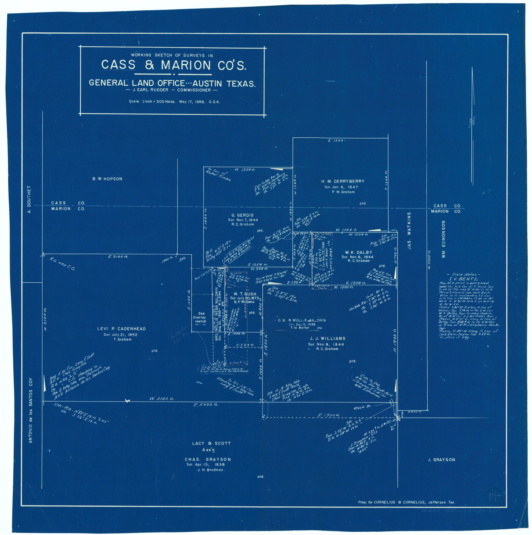
Marion County Working Sketch 14
-
Map/Doc
70790
-
Collection
General Map Collection
-
Object Dates
5/17/1956 (Creation Date)
-
People and Organizations
Otto G. Kurio (Draftsman)
-
Counties
Marion Cass
-
Subjects
Surveying Working Sketch
-
Height x Width
25.1 x 25.0 inches
63.8 x 63.5 cm
-
Scale
1" = 300 varas
Part of: General Map Collection
Midland County

Print $20.00
- Digital $50.00
Midland County
1896
Size 23.0 x 21.1 inches
Map/Doc 3878
Hardin County Working Sketch 6

Print $20.00
- Digital $50.00
Hardin County Working Sketch 6
1922
Size 16.2 x 28.4 inches
Map/Doc 63404
Kinney County Sketch File 32

Print $6.00
- Digital $50.00
Kinney County Sketch File 32
1934
Size 11.2 x 8.8 inches
Map/Doc 29178
Galveston County NRC Article 33.136 Sketch 18

Print $66.00
- Digital $50.00
Galveston County NRC Article 33.136 Sketch 18
2003
Size 22.4 x 33.9 inches
Map/Doc 78545
Van Zandt County Sketch File 22a

Print $4.00
- Digital $50.00
Van Zandt County Sketch File 22a
1858
Size 7.5 x 8.2 inches
Map/Doc 39435
Parker County Sketch File 45

Print $10.00
- Digital $50.00
Parker County Sketch File 45
1935
Size 11.0 x 8.5 inches
Map/Doc 33610
Clay County Boundary File 5

Print $6.00
- Digital $50.00
Clay County Boundary File 5
Size 11.1 x 8.5 inches
Map/Doc 51373
Bell County Working Sketch 14

Print $20.00
- Digital $50.00
Bell County Working Sketch 14
1966
Size 38.7 x 30.8 inches
Map/Doc 67354
Pecos County Rolled Sketch 90A

Print $20.00
- Digital $50.00
Pecos County Rolled Sketch 90A
1934
Size 27.0 x 31.1 inches
Map/Doc 7246
Cooke County Working Sketch 21

Print $20.00
- Digital $50.00
Cooke County Working Sketch 21
1959
Size 35.3 x 30.3 inches
Map/Doc 68258
Andrews County Sketch File 16

Print $12.00
- Digital $50.00
Andrews County Sketch File 16
1934
Size 11.2 x 8.8 inches
Map/Doc 12897
Flight Mission No. DCL-6C, Frame 12, Kenedy County

Print $20.00
- Digital $50.00
Flight Mission No. DCL-6C, Frame 12, Kenedy County
1943
Size 18.7 x 22.4 inches
Map/Doc 85869
You may also like
Austin County Working Sketch 8

Print $20.00
- Digital $50.00
Austin County Working Sketch 8
1992
Size 28.7 x 31.6 inches
Map/Doc 67249
Webb County Sketch File 17

Print $20.00
- Digital $50.00
Webb County Sketch File 17
Size 13.5 x 15.4 inches
Map/Doc 12636
Pecos County Working Sketch 94

Print $20.00
- Digital $50.00
Pecos County Working Sketch 94
1968
Size 37.8 x 38.7 inches
Map/Doc 71567
Nueces County Rolled Sketch 45

Print $20.00
- Digital $50.00
Nueces County Rolled Sketch 45
1941
Size 44.3 x 43.7 inches
Map/Doc 9603
Map of Orange County

Print $20.00
- Digital $50.00
Map of Orange County
1862
Size 13.6 x 16.5 inches
Map/Doc 3929
Throckmorton County Sketch File 7b

Print $4.00
- Digital $50.00
Throckmorton County Sketch File 7b
Size 13.0 x 6.5 inches
Map/Doc 38097
Map of the Reconnaissance in Texas by Lieuts Blake & Meade of the Corps of Topl. Engrs.

Print $20.00
- Digital $50.00
Map of the Reconnaissance in Texas by Lieuts Blake & Meade of the Corps of Topl. Engrs.
1845
Size 27.6 x 18.2 inches
Map/Doc 72894
Andrews County Boundary File 3

Print $8.00
- Digital $50.00
Andrews County Boundary File 3
Size 7.2 x 8.6 inches
Map/Doc 49717
Map of the Property traversed by the Trinity & Sabine Railroad from Fortieth Mile to Ogden, Texas

Print $40.00
- Digital $50.00
Map of the Property traversed by the Trinity & Sabine Railroad from Fortieth Mile to Ogden, Texas
1882
Size 39.5 x 93.2 inches
Map/Doc 64046
San Augustine County Sketch File 20

Print $82.00
- Digital $50.00
San Augustine County Sketch File 20
1951
Size 8.9 x 14.4 inches
Map/Doc 35680
Edwards County Rolled Sketch 16

Print $20.00
- Digital $50.00
Edwards County Rolled Sketch 16
1944
Size 29.2 x 21.1 inches
Map/Doc 5804
El Paso County Working Sketch 18

Print $40.00
- Digital $50.00
El Paso County Working Sketch 18
1960
Size 74.4 x 16.1 inches
Map/Doc 69040