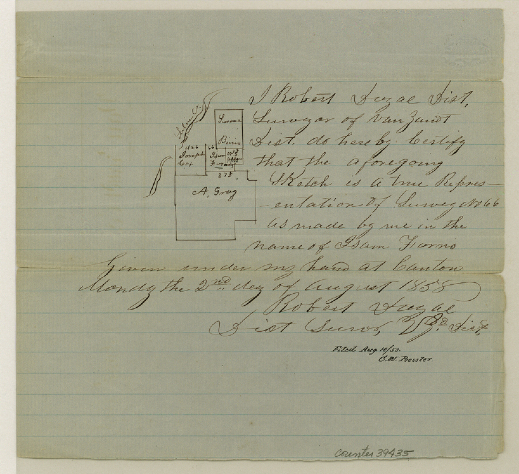
Van Zandt County Sketch File 22a
[Sketch of the large A. Gray survey and surrounding area northeast of Canton]
-
Map/Doc
39435
-
Collection
General Map Collection
-
Object Dates
8/2/1858 (Creation Date)
8/10/1858 (File Date)
-
People and Organizations
Robert Doyal (Surveyor/Engineer)
-
Counties
Van Zandt
-
Subjects
Surveying Sketch File
-
Height x Width
7.5 x 8.2 inches
19.1 x 20.8 cm
-
Medium
paper, manuscript
-
Features
Sabine River
Part of: General Map Collection
Colorado County Working Sketch 17

Print $20.00
- Digital $50.00
Colorado County Working Sketch 17
1952
Size 36.4 x 30.2 inches
Map/Doc 68117
[Copy from Harris County map]
![78371, [Copy from Harris County map], General Map Collection](https://historictexasmaps.com/wmedia_w700/maps/78371.tif.jpg)
Print $2.00
- Digital $50.00
[Copy from Harris County map]
Size 7.4 x 3.9 inches
Map/Doc 78371
Aransas County Rolled Sketch 7A

Print $20.00
- Digital $50.00
Aransas County Rolled Sketch 7A
1954
Size 30.5 x 37.6 inches
Map/Doc 76009
Kendall County Working Sketch 6

Print $20.00
- Digital $50.00
Kendall County Working Sketch 6
1947
Size 42.6 x 24.8 inches
Map/Doc 66678
[Surveys along and below the Red River and the Lamar and Fannin County line, Lamar District]
![76049, [Surveys along and below the Red River and the Lamar and Fannin County line, Lamar District], General Map Collection](https://historictexasmaps.com/wmedia_w700/maps/76049.tif.jpg)
Print $3.00
- Digital $50.00
[Surveys along and below the Red River and the Lamar and Fannin County line, Lamar District]
Size 12.1 x 10.1 inches
Map/Doc 76049
Comal County Rolled Sketch 1

Print $20.00
- Digital $50.00
Comal County Rolled Sketch 1
1972
Size 24.2 x 19.6 inches
Map/Doc 5535
Val Verde County Rolled Sketch 30

Print $20.00
- Digital $50.00
Val Verde County Rolled Sketch 30
1884
Size 43.8 x 26.4 inches
Map/Doc 8111
Knox County Sketch File 24

Print $6.00
- Digital $50.00
Knox County Sketch File 24
1945
Size 14.2 x 9.0 inches
Map/Doc 29254
La Salle County Working Sketch 56

Print $20.00
- Digital $50.00
La Salle County Working Sketch 56
2012
Size 25.5 x 23.0 inches
Map/Doc 93277
Blanco County Sketch File 1

Print $4.00
- Digital $50.00
Blanco County Sketch File 1
1874
Size 7.8 x 7.9 inches
Map/Doc 14578
[Atlas B, Table of Contents]
![78269, [Atlas B, Table of Contents], General Map Collection](https://historictexasmaps.com/wmedia_w700/maps/78269.tif.jpg)
Print $3.00
- Digital $50.00
[Atlas B, Table of Contents]
Size 10.3 x 9.6 inches
Map/Doc 78269
Sutton County Rolled Sketch 51

Print $20.00
- Digital $50.00
Sutton County Rolled Sketch 51
1950
Size 29.6 x 16.4 inches
Map/Doc 7891
You may also like
Starr County Sketch File 4

Print $3.00
- Digital $50.00
Starr County Sketch File 4
Size 9.3 x 11.5 inches
Map/Doc 36857
Lynn County Boundary File 6a

Print $2.00
- Digital $50.00
Lynn County Boundary File 6a
Size 11.2 x 8.7 inches
Map/Doc 56641
[Northern boundary line of McMullen's claim]
![313, [Northern boundary line of McMullen's claim], General Map Collection](https://historictexasmaps.com/wmedia_w700/maps/313.tif.jpg)
Print $2.00
- Digital $50.00
[Northern boundary line of McMullen's claim]
1847
Size 13.5 x 8.0 inches
Map/Doc 313
Kerr County State Real Property Sketch 1

Print $20.00
- Digital $50.00
Kerr County State Real Property Sketch 1
2007
Size 24.9 x 35.1 inches
Map/Doc 88669
Travis County Sketch File 54

Print $20.00
- Digital $50.00
Travis County Sketch File 54
1945
Size 23.0 x 16.5 inches
Map/Doc 12470

Tracing From [Melish's] Map with Kansas and the Panhandle of Texas plotted thereon Showing the disputed Territory
![76190, Tracing From [Melish's] Map with Kansas and the Panhandle of Texas plotted thereon Showing the disputed Territory, Texas State Library and Archives](https://historictexasmaps.com/wmedia_w700/maps/76190.tif.jpg)
Print $20.00
Tracing From [Melish's] Map with Kansas and the Panhandle of Texas plotted thereon Showing the disputed Territory
1818
Size 18.8 x 19.8 inches
Map/Doc 76190
Karnes County Sketch File 4

Print $8.00
- Digital $50.00
Karnes County Sketch File 4
1852
Size 5.5 x 6.8 inches
Map/Doc 28550
General Highway Map, Jim Hogg County, Texas

Print $20.00
General Highway Map, Jim Hogg County, Texas
1961
Size 24.6 x 18.2 inches
Map/Doc 79541
Hutchinson County Boundary File 3

Print $4.00
- Digital $50.00
Hutchinson County Boundary File 3
Size 11.3 x 8.9 inches
Map/Doc 55303
Mason County Sketch File 20

Print $12.00
- Digital $50.00
Mason County Sketch File 20
1901
Size 14.0 x 8.6 inches
Map/Doc 30711
Rand McNally Standard Map of Texas

Print $20.00
- Digital $50.00
Rand McNally Standard Map of Texas
1921
Size 27.7 x 40.4 inches
Map/Doc 95853