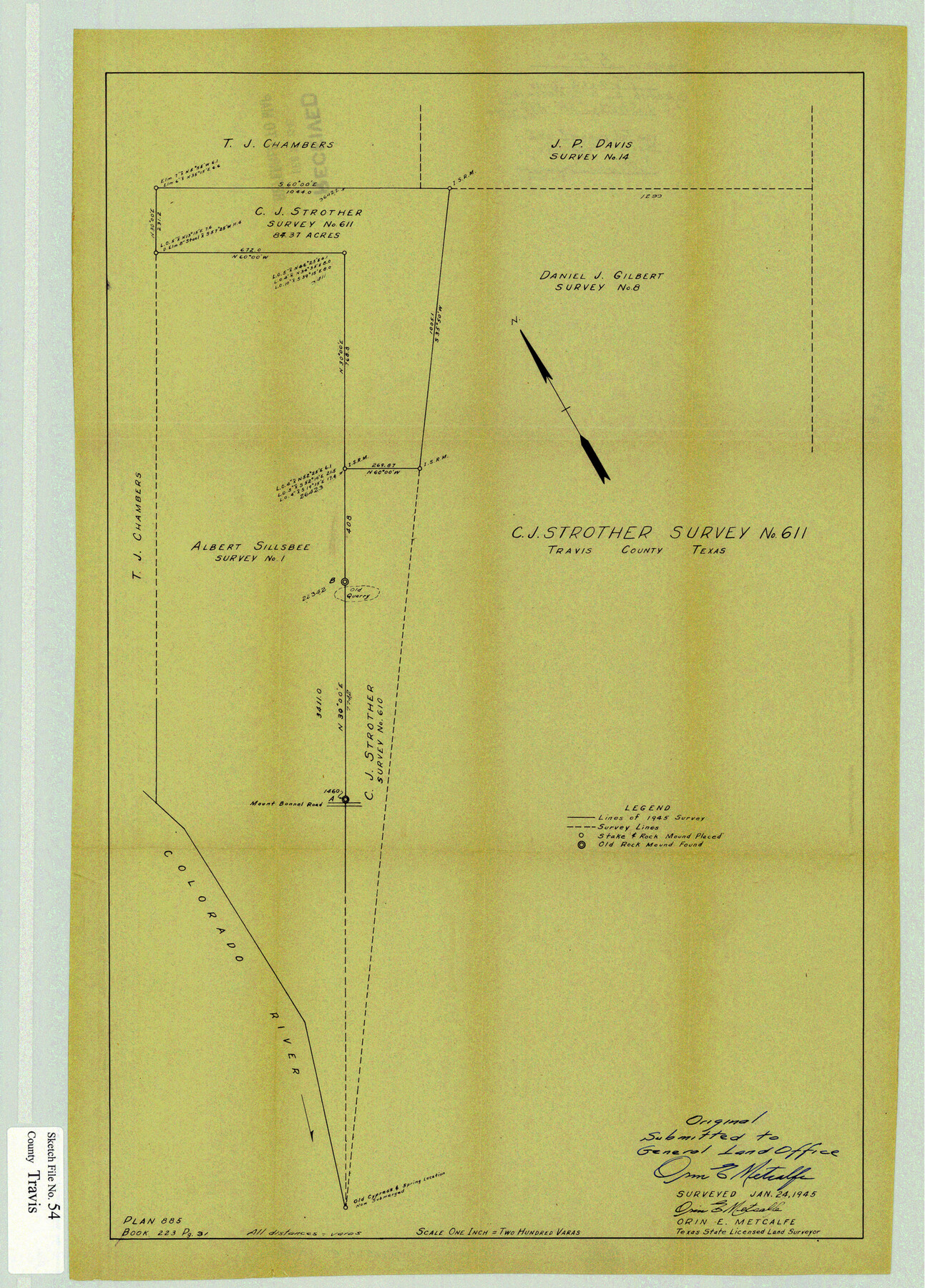
Travis County Sketch File 54
[Sketch of C.J. Strother survey no. 611]
-
Map/Doc
12470
-
Collection
General Map Collection
-
Object Dates
1/24/1945 (Creation Date)
2/8/1945 (File Date)
-
People and Organizations
Orin E. Metcalfe (Surveyor/Engineer)
-
Counties
Travis
-
Subjects
Surveying Sketch File
-
Height x Width
23.0 x 16.5 inches
58.4 x 41.9 cm
-
Medium
blueprint/diazo
-
Scale
1" = 200 varas
-
Comments
See Travis County Sketch File 53 (38395) for report.
-
Features
Mt. Bonnell Road
Colorado River
Related maps
Travis County Sketch File 53

Print $6.00
- Digital $50.00
Travis County Sketch File 53
1945
Size 14.2 x 9.0 inches
Map/Doc 38395
Part of: General Map Collection
Montgomery County Working Sketch 65

Print $20.00
- Digital $50.00
Montgomery County Working Sketch 65
1965
Size 21.5 x 16.7 inches
Map/Doc 71172
Henderson County Rolled Sketch 11

Print $20.00
- Digital $50.00
Henderson County Rolled Sketch 11
1915
Size 29.4 x 42.4 inches
Map/Doc 75950
McMullen County Working Sketch 59

Print $20.00
- Digital $50.00
McMullen County Working Sketch 59
1984
Size 24.0 x 27.7 inches
Map/Doc 70760
Boundary Between the United States & Mexico Agreed Upon by the Joint Commission under the Treaty of Guadalupe Hidalgo

Print $20.00
- Digital $50.00
Boundary Between the United States & Mexico Agreed Upon by the Joint Commission under the Treaty of Guadalupe Hidalgo
1853
Size 24.0 x 18.3 inches
Map/Doc 65396
Chart of the Rio Bravo del Norte traced from a survey made by Henry Austin by Lieut. Bowman, 3d. Infy.

Print $20.00
- Digital $50.00
Chart of the Rio Bravo del Norte traced from a survey made by Henry Austin by Lieut. Bowman, 3d. Infy.
1866
Size 18.3 x 27.8 inches
Map/Doc 72889
Potter County Rolled Sketch 13

Print $20.00
- Digital $50.00
Potter County Rolled Sketch 13
2004
Size 19.3 x 23.5 inches
Map/Doc 82478
Flight Mission No. CGI-2N, Frame 152, Cameron County

Print $20.00
- Digital $50.00
Flight Mission No. CGI-2N, Frame 152, Cameron County
1954
Size 18.7 x 22.1 inches
Map/Doc 84534

Erath County Sketch File 10

Print $4.00
- Digital $50.00
Erath County Sketch File 10
1871
Size 8.1 x 10.3 inches
Map/Doc 22275
Anderson County Working Sketch 15

Print $20.00
- Digital $50.00
Anderson County Working Sketch 15
1937
Size 19.7 x 22.7 inches
Map/Doc 67015
Mason County Rolled Sketch 1

Print $20.00
- Digital $50.00
Mason County Rolled Sketch 1
1940
Size 21.2 x 24.9 inches
Map/Doc 6674
Origins of Exports and Destination of Imports at Houston during 1921

Print $20.00
- Digital $50.00
Origins of Exports and Destination of Imports at Houston during 1921
1921
Size 13.6 x 19.6 inches
Map/Doc 97170
You may also like
Hill County Sketch File 8

Print $4.00
- Digital $50.00
Hill County Sketch File 8
1859
Size 10.1 x 8.2 inches
Map/Doc 26472
Archer County

Print $20.00
- Digital $50.00
Archer County
1898
Size 36.0 x 39.4 inches
Map/Doc 93033
Pecos County Working Sketch 39

Print $20.00
- Digital $50.00
Pecos County Working Sketch 39
1940
Size 37.5 x 37.6 inches
Map/Doc 71511
Duval County Rolled Sketch 20A

Print $20.00
- Digital $50.00
Duval County Rolled Sketch 20A
Size 34.6 x 43.7 inches
Map/Doc 8816
Atascosa County Working Sketch 5

Print $3.00
- Digital $50.00
Atascosa County Working Sketch 5
1913
Size 10.9 x 11.3 inches
Map/Doc 67201
Morris County Rolled Sketch 2A

Print $20.00
- Digital $50.00
Morris County Rolled Sketch 2A
Size 24.4 x 19.4 inches
Map/Doc 10245
Calhoun County Working Sketch 13

Print $20.00
- Digital $50.00
Calhoun County Working Sketch 13
1962
Size 28.5 x 31.9 inches
Map/Doc 67829
Flight Mission No. DIX-3P, Frame 138, Aransas County

Print $20.00
- Digital $50.00
Flight Mission No. DIX-3P, Frame 138, Aransas County
1956
Size 17.7 x 18.6 inches
Map/Doc 83768
Nueces County Working Sketch 11

Print $20.00
- Digital $50.00
Nueces County Working Sketch 11
1965
Size 20.2 x 44.1 inches
Map/Doc 71313
Matagorda County Working Sketch 20

Print $20.00
- Digital $50.00
Matagorda County Working Sketch 20
1961
Size 26.1 x 37.7 inches
Map/Doc 70878
Flight Mission No. BRE-2P, Frame 22, Nueces County

Print $20.00
- Digital $50.00
Flight Mission No. BRE-2P, Frame 22, Nueces County
1956
Size 18.7 x 22.6 inches
Map/Doc 86731
Map Exhibit B, R. B. Violette, M. A. 34719, Gaines County, Texas

Print $20.00
- Digital $50.00
Map Exhibit B, R. B. Violette, M. A. 34719, Gaines County, Texas
Size 30.3 x 23.3 inches
Map/Doc 92654