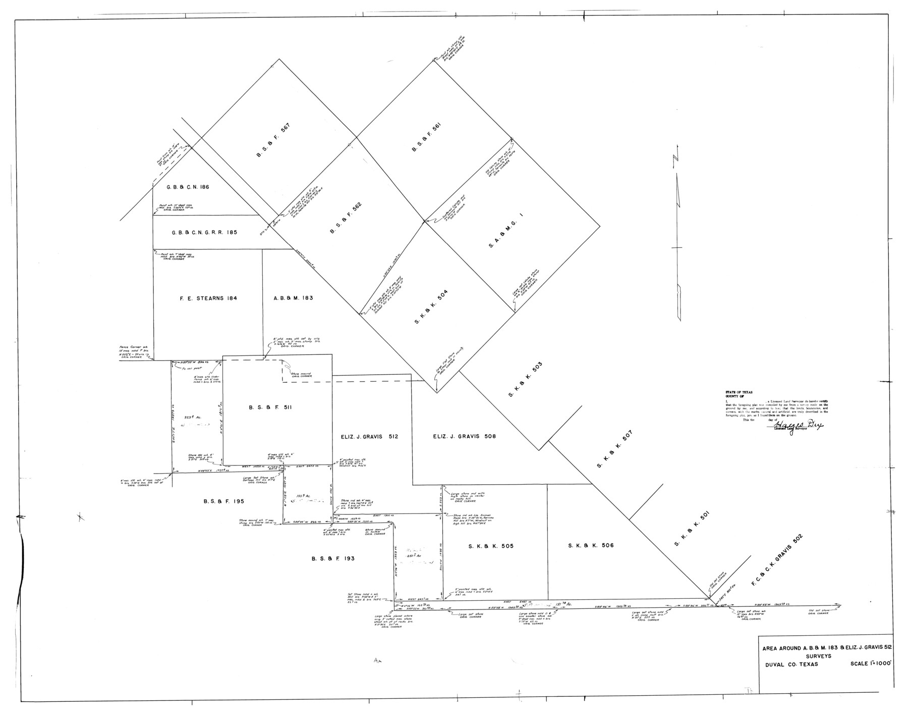
Duval County Rolled Sketch 20A
Area around A. B. & M. 183 & Eliz. J. Gravis 512 surveys
-
Map/Doc
8816
-
Collection
General Map Collection
-
Object Dates
1941/3/19 (File Date)
-
People and Organizations
Hayes Dix (Surveyor/Engineer)
-
Counties
Duval
-
Subjects
Surveying Rolled Sketch
-
Height x Width
34.6 x 43.7 inches
87.9 x 111.0 cm
-
Scale
1" = 1000 feet
Part of: General Map Collection
Potter County Sketch File 15

Print $20.00
- Digital $50.00
Potter County Sketch File 15
Size 19.5 x 21.1 inches
Map/Doc 12201
Map of Travis County

Print $20.00
- Digital $50.00
Map of Travis County
1861
Size 21.2 x 25.3 inches
Map/Doc 4087
Montgomery County Rolled Sketch 37

Print $40.00
- Digital $50.00
Montgomery County Rolled Sketch 37
Size 44.3 x 52.7 inches
Map/Doc 9544
Brewster County Sketch File N-2

Print $44.00
- Digital $50.00
Brewster County Sketch File N-2
1881
Size 8.2 x 12.8 inches
Map/Doc 15567
Trinity River, Ferris Sheet/Ten Mile Creek

Print $4.00
- Digital $50.00
Trinity River, Ferris Sheet/Ten Mile Creek
1935
Size 20.1 x 25.1 inches
Map/Doc 65242
Right of Way & Track Map, St. Louis, Brownsville & Mexico Ry. operated by St. Louis, Brownsville & Mexico Ry. Co.

Print $40.00
- Digital $50.00
Right of Way & Track Map, St. Louis, Brownsville & Mexico Ry. operated by St. Louis, Brownsville & Mexico Ry. Co.
1919
Size 25.4 x 56.9 inches
Map/Doc 64623
El Paso County Working Sketch 29

Print $40.00
- Digital $50.00
El Paso County Working Sketch 29
1967
Size 43.0 x 64.8 inches
Map/Doc 69051
Nacogdoches County Sketch File 5

Print $4.00
- Digital $50.00
Nacogdoches County Sketch File 5
1859
Size 12.6 x 8.1 inches
Map/Doc 32243
Zavala County Sketch File A1

Print $31.00
- Digital $50.00
Zavala County Sketch File A1
1899
Size 23.5 x 28.6 inches
Map/Doc 12735
Texas Gulf Coast from Sabine River to the Rio Grande

Print $20.00
- Digital $50.00
Texas Gulf Coast from Sabine River to the Rio Grande
1953
Size 45.9 x 43.6 inches
Map/Doc 2945
Aransas County Sketch File 24

Print $36.00
- Digital $50.00
Aransas County Sketch File 24
1938
Size 10.9 x 8.3 inches
Map/Doc 13177
Map of section no. 7 of a survey of Padre Island made for the Office of the Attorney General of the State of Texas

Print $40.00
- Digital $50.00
Map of section no. 7 of a survey of Padre Island made for the Office of the Attorney General of the State of Texas
1941
Size 56.3 x 41.2 inches
Map/Doc 2263
You may also like
Map of the Fort Worth and Denver City Railway, through Wilbarger County Texas, 1882

Print $40.00
- Digital $50.00
Map of the Fort Worth and Denver City Railway, through Wilbarger County Texas, 1882
Size 22.9 x 121.1 inches
Map/Doc 64426
Jeff Davis County Working Sketch 9

Print $20.00
- Digital $50.00
Jeff Davis County Working Sketch 9
1943
Size 28.5 x 27.3 inches
Map/Doc 66504
Brewster County Sketch File B-1

Print $6.00
- Digital $50.00
Brewster County Sketch File B-1
1910
Size 14.2 x 8.8 inches
Map/Doc 15716
[Sketch of area around R. D. Price and Berry Doolittle Surveys]
![91878, [Sketch of area around R. D. Price and Berry Doolittle Surveys], Twichell Survey Records](https://historictexasmaps.com/wmedia_w700/maps/91878-1.tif.jpg)
Print $20.00
- Digital $50.00
[Sketch of area around R. D. Price and Berry Doolittle Surveys]
Size 27.4 x 19.8 inches
Map/Doc 91878
Donley County Sketch File 30

Print $24.00
- Digital $50.00
Donley County Sketch File 30
1906
Size 11.3 x 8.7 inches
Map/Doc 21270
Angelina County Working Sketch 29

Print $20.00
- Digital $50.00
Angelina County Working Sketch 29
1955
Size 24.9 x 23.3 inches
Map/Doc 67111
Stephens County Sketch File 12a

Print $23.00
- Digital $50.00
Stephens County Sketch File 12a
Size 18.2 x 11.2 inches
Map/Doc 37061
Map from the Sabine River to the Rio Grande as subdivided for mineral development

Print $40.00
- Digital $50.00
Map from the Sabine River to the Rio Grande as subdivided for mineral development
Size 43.5 x 72.5 inches
Map/Doc 65802
Liberty County Rolled Sketch 13

Print $20.00
- Digital $50.00
Liberty County Rolled Sketch 13
1983
Size 27.0 x 37.8 inches
Map/Doc 6619
Cameron County Rolled Sketch 15

Print $40.00
- Digital $50.00
Cameron County Rolled Sketch 15
1958
Size 53.0 x 32.0 inches
Map/Doc 8568
Crane County Rolled Sketch 27

Print $20.00
- Digital $50.00
Crane County Rolled Sketch 27
2020
Size 36.3 x 24.3 inches
Map/Doc 96433
Flight Mission No. DAG-17K, Frame 124, Matagorda County

Print $20.00
- Digital $50.00
Flight Mission No. DAG-17K, Frame 124, Matagorda County
1952
Size 18.6 x 22.3 inches
Map/Doc 86344