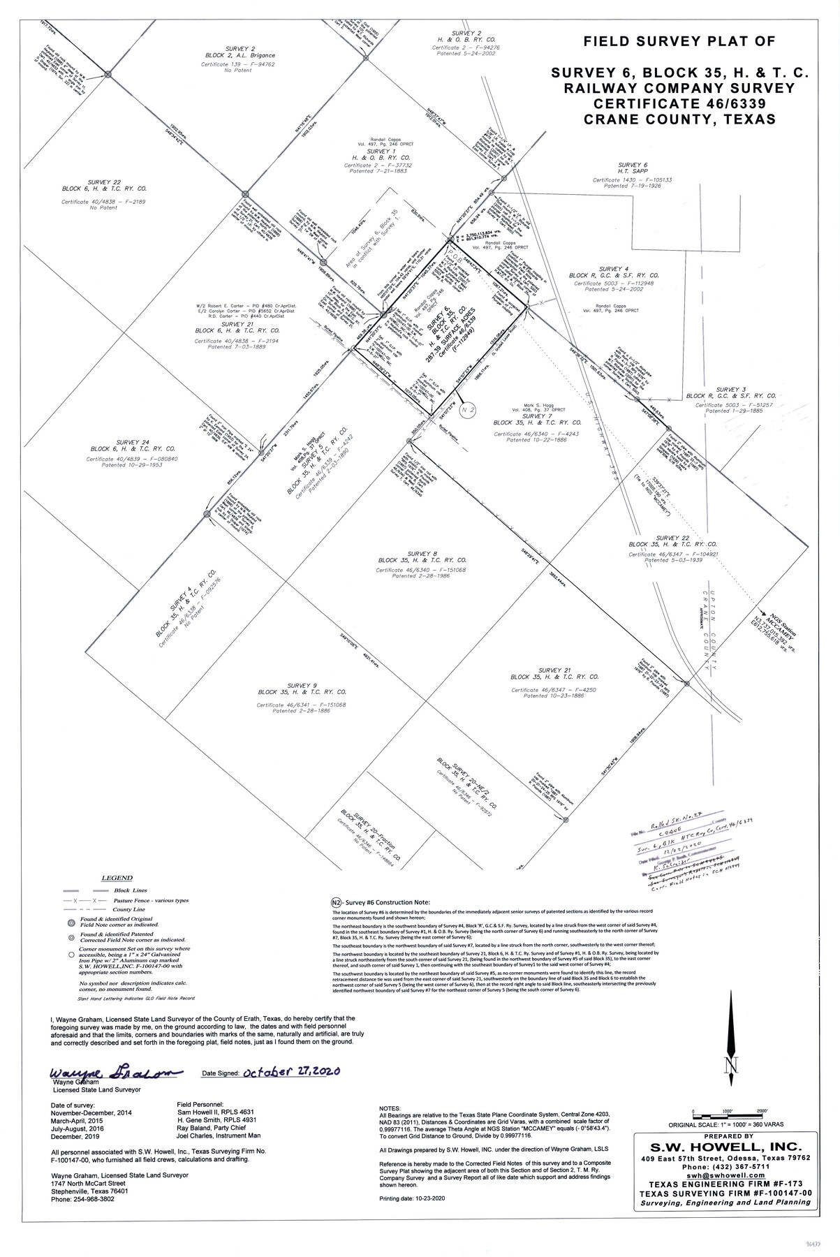
Crane County Rolled Sketch 27
Field survey plat of survey 6, Block 35, H. & T. C. Railway Company survey, certificate 46/6339, Crane County, Texas
-
Map/Doc
96433
-
Collection
General Map Collection
-
Object Dates
2020/10/27 (Creation Date)
2020/12/2 (File Date)
-
People and Organizations
Wayne Graham (Surveyor/Engineer)
Sam Howell II (Chainman/Field Personnel)
H. Gene Smith (Chainman/Field Personnel)
Ray Baland (Chainman/Field Personnel)
Joel Charles (Chainman/Field Personnel)
-
Counties
Crane
-
Subjects
Surveying Rolled Sketch
-
Height x Width
36.3 x 24.3 inches
92.2 x 61.7 cm
-
Medium
mylar, print
-
Scale
1" = 360 varas
-
Comments
Corrected field notes in SCH 112949.
Part of: General Map Collection
Howard County Sketch File 12

Print $20.00
- Digital $50.00
Howard County Sketch File 12
1939
Size 18.2 x 15.7 inches
Map/Doc 11799
Pecos County Rolled Sketch 89

Print $40.00
- Digital $50.00
Pecos County Rolled Sketch 89
1934
Size 56.2 x 41.4 inches
Map/Doc 10719

Liberty County Working Sketch 37

Print $20.00
- Digital $50.00
Liberty County Working Sketch 37
1948
Size 25.4 x 26.8 inches
Map/Doc 70496
Jefferson County Rolled Sketch 60

Print $20.00
- Digital $50.00
Jefferson County Rolled Sketch 60
1885
Size 31.0 x 35.6 inches
Map/Doc 9315
Lamb County Sketch File B

Print $6.00
- Digital $50.00
Lamb County Sketch File B
1902
Size 11.2 x 8.8 inches
Map/Doc 29344
Gonzales County Working Sketch 12

Print $20.00
- Digital $50.00
Gonzales County Working Sketch 12
1981
Size 13.1 x 11.9 inches
Map/Doc 63228
Culberson County Rolled Sketch 15

Print $20.00
- Digital $50.00
Culberson County Rolled Sketch 15
1904
Size 30.5 x 40.2 inches
Map/Doc 8744
[Right of Way & Track Map, The Texas & Pacific Ry. Co. Main Line]
![64669, [Right of Way & Track Map, The Texas & Pacific Ry. Co. Main Line], General Map Collection](https://historictexasmaps.com/wmedia_w700/maps/64669.tif.jpg)
Print $20.00
- Digital $50.00
[Right of Way & Track Map, The Texas & Pacific Ry. Co. Main Line]
Size 11.0 x 18.5 inches
Map/Doc 64669
Duval County Boundary File 3i

Print $4.00
- Digital $50.00
Duval County Boundary File 3i
Size 8.3 x 10.3 inches
Map/Doc 52751
Kinney County Sketch File D

Print $20.00
- Digital $50.00
Kinney County Sketch File D
1885
Size 25.1 x 35.6 inches
Map/Doc 11953
Hardin County Rolled Sketch 15

Print $20.00
- Digital $50.00
Hardin County Rolled Sketch 15
Size 25.5 x 26.6 inches
Map/Doc 6085
You may also like
Magnetic Declination in the United States - Epoch 1980

Print $20.00
- Digital $50.00
Magnetic Declination in the United States - Epoch 1980
1980
Size 41.3 x 33.2 inches
Map/Doc 92367
Pecos County Working Sketch 37

Print $20.00
- Digital $50.00
Pecos County Working Sketch 37
1939
Size 30.0 x 43.0 inches
Map/Doc 71509
Nueces County Rolled Sketch 65

Print $20.00
- Digital $50.00
Nueces County Rolled Sketch 65
1979
Size 19.5 x 26.2 inches
Map/Doc 6917
Hemphill County

Print $20.00
- Digital $50.00
Hemphill County
1899
Size 42.2 x 34.1 inches
Map/Doc 4682
[Ezekiel Ables and surrounding surveys]
![90966, [Ezekiel Ables and surrounding surveys], Twichell Survey Records](https://historictexasmaps.com/wmedia_w700/maps/90966-1.tif.jpg)
Print $20.00
- Digital $50.00
[Ezekiel Ables and surrounding surveys]
Size 12.6 x 18.0 inches
Map/Doc 90966
Gulf of Mexico

Print $20.00
- Digital $50.00
Gulf of Mexico
1905
Size 18.3 x 26.8 inches
Map/Doc 72652
A new map of Texas, Oregon and California with the regions adjoining, compiled from the most recent authorities

Print $20.00
- Digital $50.00
A new map of Texas, Oregon and California with the regions adjoining, compiled from the most recent authorities
1846
Size 23.7 x 21.8 inches
Map/Doc 93940
![89627, [Blks. 46 & 47], Twichell Survey Records](https://historictexasmaps.com/wmedia_w700/maps/89627-1.tif.jpg)
Terry County Sketch File 11

Print $20.00
- Digital $50.00
Terry County Sketch File 11
Size 10.9 x 43.2 inches
Map/Doc 10395
Aransas County NRC Article 33.136 Location Key Sheet

Print $20.00
- Digital $50.00
Aransas County NRC Article 33.136 Location Key Sheet
1970
Size 27.0 x 23.0 inches
Map/Doc 87904
Upton County Working Sketch 1

Print $20.00
- Digital $50.00
Upton County Working Sketch 1
1906
Size 11.6 x 20.0 inches
Map/Doc 69497
Flight Mission No. DQO-14T, Frame 66, Galveston County

Print $20.00
- Digital $50.00
Flight Mission No. DQO-14T, Frame 66, Galveston County
1958
Size 17.6 x 17.4 inches
Map/Doc 85217