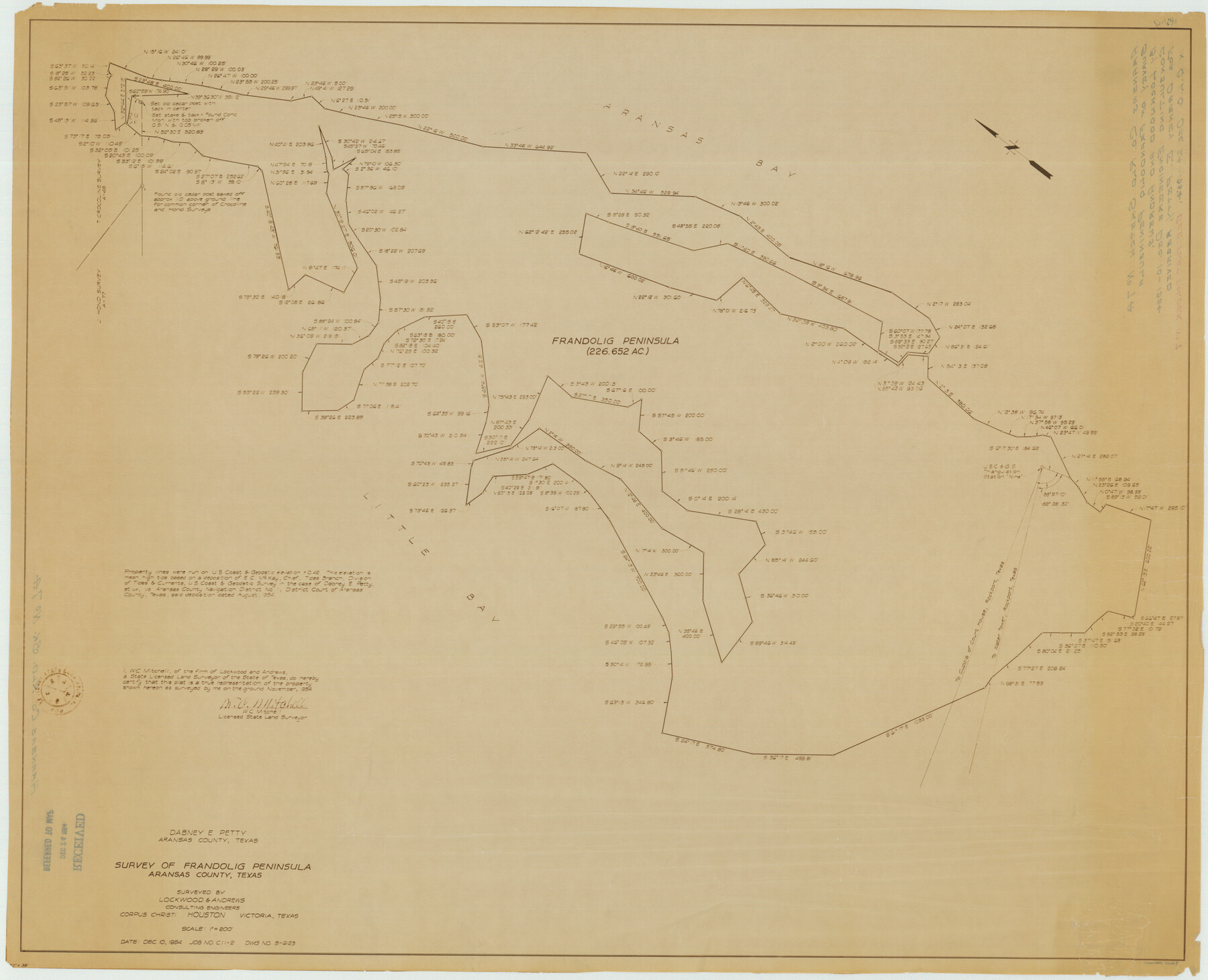
Aransas County Rolled Sketch 7A
Survey of Frandolig Peninsula, Aransas County, Texas
-
Map/Doc
76009
-
Collection
General Map Collection
-
Object Dates
1954/12/10 (Creation Date)
1954/12/24 (File Date)
1954 (Survey Date)
-
People and Organizations
W.C. Mitchell (Surveyor/Engineer)
-
Counties
Aransas
-
Subjects
Surveying Rolled Sketch
-
Height x Width
30.5 x 37.6 inches
77.5 x 95.5 cm
Related maps
Aransas County Rolled Sketch 7

Print $437.00
- Digital $50.00
Aransas County Rolled Sketch 7
Map/Doc 42081
Part of: General Map Collection
Aransas Pass to Baffin Bay

Print $20.00
- Digital $50.00
Aransas Pass to Baffin Bay
1981
Size 43.0 x 35.0 inches
Map/Doc 73420
Hood County Working Sketch 18

Print $40.00
- Digital $50.00
Hood County Working Sketch 18
1987
Size 38.8 x 59.0 inches
Map/Doc 66212
Hutchinson County Sketch File 12

Print $40.00
- Digital $50.00
Hutchinson County Sketch File 12
1908
Size 16.1 x 15.7 inches
Map/Doc 27211
Montgomery County Rolled Sketch 47

Print $20.00
- Digital $50.00
Montgomery County Rolled Sketch 47
2009
Size 36.5 x 24.6 inches
Map/Doc 89032
Matagorda County Rolled Sketch 22

Print $20.00
- Digital $50.00
Matagorda County Rolled Sketch 22
Size 30.7 x 23.9 inches
Map/Doc 6689

No. 2 Chart of Corpus Christi Pass, Texas

Print $20.00
- Digital $50.00
No. 2 Chart of Corpus Christi Pass, Texas
1878
Size 18.3 x 27.2 inches
Map/Doc 73028
Gray County Working Sketch 6

Print $20.00
- Digital $50.00
Gray County Working Sketch 6
1960
Size 28.8 x 23.2 inches
Map/Doc 63237
Van Zandt County Sketch File 6

Print $4.00
- Digital $50.00
Van Zandt County Sketch File 6
1848
Size 9.7 x 7.9 inches
Map/Doc 39373
Harrison County Working Sketch 2

Print $20.00
- Digital $50.00
Harrison County Working Sketch 2
1940
Size 40.3 x 36.0 inches
Map/Doc 66022
Jasper County Rolled Sketch 8

Print $3.00
- Digital $50.00
Jasper County Rolled Sketch 8
Size 17.7 x 11.9 inches
Map/Doc 6357
Gregg County Rolled Sketch 16A

Print $20.00
- Digital $50.00
Gregg County Rolled Sketch 16A
1942
Size 30.1 x 40.4 inches
Map/Doc 6039
You may also like
[Map] of Goliad Land District
![3586, [Map] of Goliad Land District, General Map Collection](https://historictexasmaps.com/wmedia_w700/maps/3586-1.tif.jpg)
Print $20.00
- Digital $50.00
[Map] of Goliad Land District
1856
Size 33.5 x 25.2 inches
Map/Doc 3586
[State Capitol Leagues along Bailey-Lamb County Line]
![90163, [State Capitol Leagues along Bailey-Lamb County Line], Twichell Survey Records](https://historictexasmaps.com/wmedia_w700/maps/90163-1.tif.jpg)
Print $20.00
- Digital $50.00
[State Capitol Leagues along Bailey-Lamb County Line]
Size 20.7 x 21.3 inches
Map/Doc 90163
Orange County - Sabine River Leases 1, 2, 3, & 4

Print $20.00
- Digital $50.00
Orange County - Sabine River Leases 1, 2, 3, & 4
1918
Size 38.6 x 23.0 inches
Map/Doc 2900
Nueces County Sketch File 85

Print $2.00
- Digital $50.00
Nueces County Sketch File 85
Size 11.0 x 8.5 inches
Map/Doc 82922
Jim Wells Co.

Print $20.00
- Digital $50.00
Jim Wells Co.
1966
Size 42.7 x 31.0 inches
Map/Doc 73198
Carta General de la República Mexicana Formada para el estudio de la configuracion y division interior de su territorio

Print $20.00
- Digital $50.00
Carta General de la República Mexicana Formada para el estudio de la configuracion y division interior de su territorio
Size 23.2 x 29.4 inches
Map/Doc 95823
Carson County Sketch File 4

Print $4.00
- Digital $50.00
Carson County Sketch File 4
1901
Size 9.7 x 6.2 inches
Map/Doc 17351
Brewster County Rolled Sketch A

Print $40.00
- Digital $50.00
Brewster County Rolled Sketch A
Size 26.7 x 94.8 inches
Map/Doc 8925
Montague County Rolled Sketch 2

Print $20.00
- Digital $50.00
Montague County Rolled Sketch 2
1940
Size 32.5 x 35.5 inches
Map/Doc 9525
Hale County Rolled Sketch 3

Print $40.00
- Digital $50.00
Hale County Rolled Sketch 3
1891
Size 51.7 x 24.1 inches
Map/Doc 9093
General Highway Map. Detail of Cities and Towns in Henderson County, Texas

Print $20.00
General Highway Map. Detail of Cities and Towns in Henderson County, Texas
1939
Size 18.6 x 25.0 inches
Map/Doc 79126
Coke County Sketch File 15

Print $12.00
- Digital $50.00
Coke County Sketch File 15
1893
Size 5.6 x 8.6 inches
Map/Doc 18600