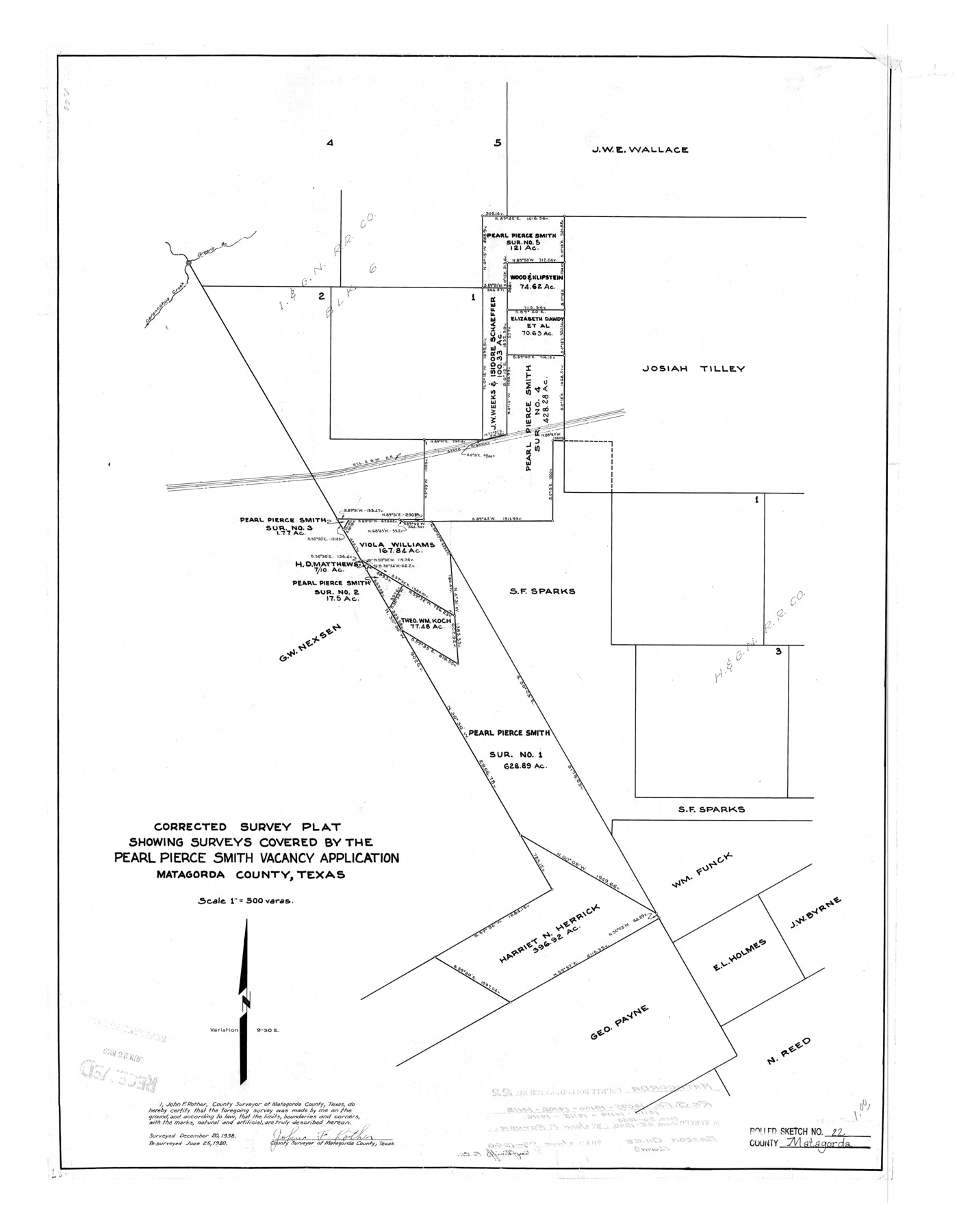
Matagorda County Rolled Sketch 22
Corrected survey plat showing surveys covered by the Pearl Pierce Smith vacancy application
-
Map/Doc
6689
-
Collection
General Map Collection
-
Object Dates
1938/12/20 (Survey Date)
1940/6/28 (File Date)
1940/6/25 (Survey Date)
-
People and Organizations
John F. Rother (Surveyor/Engineer)
-
Counties
Matagorda
-
Subjects
Surveying Rolled Sketch
-
Height x Width
30.7 x 23.9 inches
78.0 x 60.7 cm
-
Scale
1" = 500 varas
Part of: General Map Collection
Coke County Working Sketch 11

Print $20.00
- Digital $50.00
Coke County Working Sketch 11
1945
Size 40.9 x 40.2 inches
Map/Doc 68048
Val Verde County Working Sketch 60

Print $20.00
- Digital $50.00
Val Verde County Working Sketch 60
1958
Size 32.1 x 32.4 inches
Map/Doc 72195
Jefferson County Sketch File X

Print $42.00
- Digital $50.00
Jefferson County Sketch File X
Size 17.1 x 13.3 inches
Map/Doc 28087
Flight Mission No. CUG-2P, Frame 61, Kleberg County

Print $20.00
- Digital $50.00
Flight Mission No. CUG-2P, Frame 61, Kleberg County
1956
Size 18.5 x 22.2 inches
Map/Doc 86198
Map of Galveston Bay from Lawrence Cove to Stevenson's Station

Print $20.00
- Digital $50.00
Map of Galveston Bay from Lawrence Cove to Stevenson's Station
1851
Size 41.5 x 30.0 inches
Map/Doc 69922
Flight Mission No. CRE-1R, Frame 133, Jackson County

Print $20.00
- Digital $50.00
Flight Mission No. CRE-1R, Frame 133, Jackson County
1956
Size 16.2 x 16.2 inches
Map/Doc 85341
Flight Mission No. BRA-8M, Frame 128, Jefferson County

Print $20.00
- Digital $50.00
Flight Mission No. BRA-8M, Frame 128, Jefferson County
1953
Size 18.6 x 22.3 inches
Map/Doc 85624
Wise County Sketch File 49

Print $20.00
- Digital $50.00
Wise County Sketch File 49
1882
Size 15.5 x 20.8 inches
Map/Doc 12702
Culberson County Working Sketch 26

Print $20.00
- Digital $50.00
Culberson County Working Sketch 26
1951
Size 42.7 x 28.3 inches
Map/Doc 68479
Schleicher County

Print $40.00
- Digital $50.00
Schleicher County
1898
Size 35.9 x 53.7 inches
Map/Doc 63027
Flight Mission No. CUG-1P, Frame 75, Kleberg County

Print $20.00
- Digital $50.00
Flight Mission No. CUG-1P, Frame 75, Kleberg County
1956
Size 18.5 x 22.3 inches
Map/Doc 86140
Mirando City, Webb County, Texas

Print $40.00
- Digital $50.00
Mirando City, Webb County, Texas
1937
Size 60.0 x 36.2 inches
Map/Doc 10132
You may also like
Brewster County Sketch File N-3d

Print $13.00
- Digital $50.00
Brewster County Sketch File N-3d
1889
Size 14.2 x 8.7 inches
Map/Doc 15596

Terry County Rolled Sketch 8

Print $20.00
- Digital $50.00
Terry County Rolled Sketch 8
Size 31.7 x 22.3 inches
Map/Doc 7982
Gregg County Working Sketch Graphic Index

Print $20.00
- Digital $50.00
Gregg County Working Sketch Graphic Index
1933
Size 32.4 x 29.5 inches
Map/Doc 76559
Houston County Sketch File 19

Print $4.00
- Digital $50.00
Houston County Sketch File 19
1851
Size 12.8 x 8.3 inches
Map/Doc 26785
Grayson County Sketch File 1

Print $2.00
- Digital $50.00
Grayson County Sketch File 1
1854
Size 8.4 x 3.3 inches
Map/Doc 24459
Glasscock County Sketch File 12

Print $5.00
- Digital $50.00
Glasscock County Sketch File 12
1935
Size 14.1 x 9.2 inches
Map/Doc 24176
Map of Drum, Oyster & Bastrop Bays & vicinity in Brazoria County showing subdivision for mineral development

Print $20.00
- Digital $50.00
Map of Drum, Oyster & Bastrop Bays & vicinity in Brazoria County showing subdivision for mineral development
Size 36.8 x 47.3 inches
Map/Doc 65808
Index for Texas Railroad ROW & track maps available on microfilm at THD & Archives and Records

Print $2.00
- Digital $50.00
Index for Texas Railroad ROW & track maps available on microfilm at THD & Archives and Records
1977
Size 11.1 x 8.6 inches
Map/Doc 60763
Cherokee County Boundary File 2

Print $11.00
- Digital $50.00
Cherokee County Boundary File 2
Size 16.1 x 9.9 inches
Map/Doc 51280
Southeast Corner of Gray County

Print $20.00
- Digital $50.00
Southeast Corner of Gray County
1882
Size 18.8 x 22.6 inches
Map/Doc 90757
San Patricio County Sketch File 35

Print $16.00
- Digital $50.00
San Patricio County Sketch File 35
1917
Size 14.5 x 8.8 inches
Map/Doc 36121