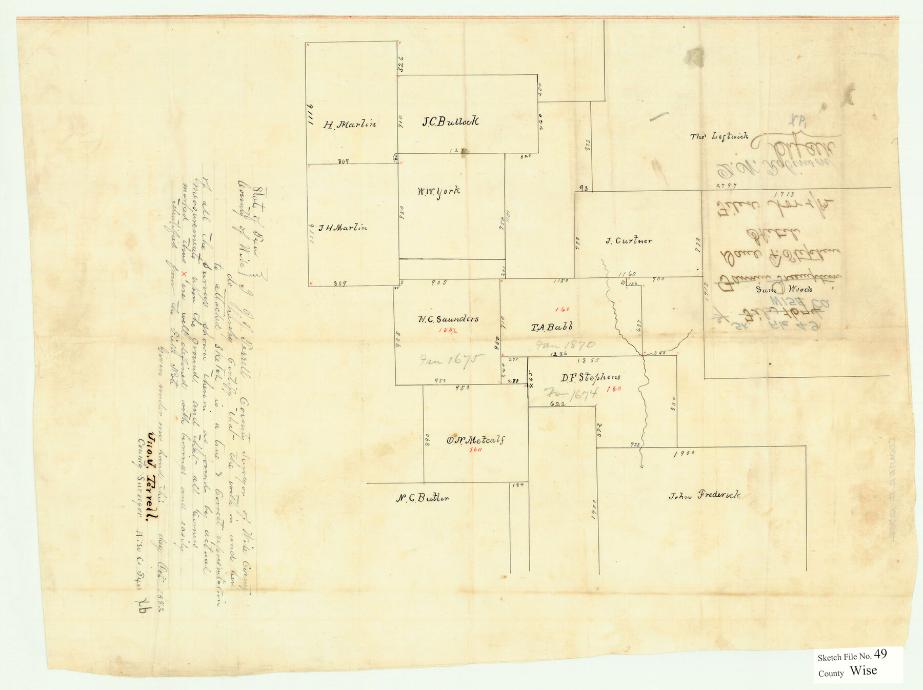
Wise County Sketch File 49
[Sketch of surveys around the D.F. Stephens survey west from Decatur]
-
Map/Doc
12702
-
Collection
General Map Collection
-
Object Dates
10/1882 (Creation Date)
-
People and Organizations
John J. Terrell (Surveyor/Engineer)
-
Counties
Wise
-
Subjects
Surveying Sketch File
-
Height x Width
15.5 x 20.8 inches
39.4 x 52.8 cm
-
Medium
paper, manuscript
Part of: General Map Collection
Gaines County Working Sketch 8

Print $20.00
- Digital $50.00
Gaines County Working Sketch 8
1951
Size 21.8 x 24.8 inches
Map/Doc 69308
Gaines County Working Sketch 36

Print $20.00
- Digital $50.00
Gaines County Working Sketch 36
Size 23.5 x 36.7 inches
Map/Doc 69336
Orange County Sketch File 36

Print $22.00
- Digital $50.00
Orange County Sketch File 36
Size 27.7 x 8.8 inches
Map/Doc 33372
Calhoun County NRC Article 33.136 Sketch 3

Print $40.00
- Digital $50.00
Calhoun County NRC Article 33.136 Sketch 3
2000
Size 24.4 x 36.5 inches
Map/Doc 81914
Fayette County Sketch File 3

Print $6.00
- Digital $50.00
Fayette County Sketch File 3
1863
Size 8.3 x 10.7 inches
Map/Doc 22501
Llano County Boundary File 2

Print $30.00
- Digital $50.00
Llano County Boundary File 2
Size 14.3 x 8.8 inches
Map/Doc 56443
Dimmit County Sketch File 60

Print $4.00
- Digital $50.00
Dimmit County Sketch File 60
1991
Size 14.2 x 8.8 inches
Map/Doc 21206
Armstrong County

Print $20.00
- Digital $50.00
Armstrong County
1879
Size 21.6 x 19.2 inches
Map/Doc 3242
Webb County Sketch File 9-1

Print $20.00
- Digital $50.00
Webb County Sketch File 9-1
1879
Size 15.8 x 15.7 inches
Map/Doc 12622
Flight Mission No. DAG-23K, Frame 171, Matagorda County

Print $20.00
- Digital $50.00
Flight Mission No. DAG-23K, Frame 171, Matagorda County
1953
Size 18.6 x 22.4 inches
Map/Doc 86509
Sutton County Working Sketch 38

Print $20.00
- Digital $50.00
Sutton County Working Sketch 38
1942
Size 35.2 x 26.1 inches
Map/Doc 62381
Geological Map of Texas

Print $20.00
- Digital $50.00
Geological Map of Texas
1919
Size 34.9 x 36.8 inches
Map/Doc 94091
You may also like
Jackson County Rolled Sketch 2

Print $20.00
- Digital $50.00
Jackson County Rolled Sketch 2
Size 14.1 x 17.9 inches
Map/Doc 6335
[Sketch showing North line of James Stewart survey and vicinity]
![90116, [Sketch showing North line of James Stewart survey and vicinity], Twichell Survey Records](https://historictexasmaps.com/wmedia_w700/maps/90116-1.tif.jpg)
Print $20.00
- Digital $50.00
[Sketch showing North line of James Stewart survey and vicinity]
Size 30.0 x 9.0 inches
Map/Doc 90116
Padre Island National Seashore, Texas - Dependent Resurvey

Print $4.00
- Digital $50.00
Padre Island National Seashore, Texas - Dependent Resurvey
2001
Size 18.2 x 24.3 inches
Map/Doc 60548
Pecos County Working Sketch 140

Print $20.00
- Digital $50.00
Pecos County Working Sketch 140
1983
Size 43.1 x 42.9 inches
Map/Doc 71614
Cameron County Aerial Photograph Index Sheet 5

Print $20.00
- Digital $50.00
Cameron County Aerial Photograph Index Sheet 5
1940
Size 20.4 x 24.3 inches
Map/Doc 83681
El Paso County Sketch File 5

Print $20.00
- Digital $50.00
El Paso County Sketch File 5
Size 25.3 x 18.9 inches
Map/Doc 11450
Navigation Maps of Gulf Intracoastal Waterway, Port Arthur to Brownsville, Texas

Print $4.00
- Digital $50.00
Navigation Maps of Gulf Intracoastal Waterway, Port Arthur to Brownsville, Texas
1951
Size 16.5 x 21.1 inches
Map/Doc 65435
The United States of America

Print $20.00
- Digital $50.00
The United States of America
1866
Size 21.3 x 18.3 inches
Map/Doc 72646
Brewster County Rolled Sketch 123

Print $25.00
- Digital $50.00
Brewster County Rolled Sketch 123
Size 10.1 x 15.3 inches
Map/Doc 43129
McMullen County Working Sketch 9

Print $40.00
- Digital $50.00
McMullen County Working Sketch 9
1937
Size 58.8 x 36.9 inches
Map/Doc 70710
Galveston County NRC Article 33.136 Sketch 16

Print $28.00
- Digital $50.00
Galveston County NRC Article 33.136 Sketch 16
2002
Size 25.3 x 36.2 inches
Map/Doc 78314
[Survey 1, Block MT, and vicinity]
![90683, [Survey 1, Block MT, and vicinity], Twichell Survey Records](https://historictexasmaps.com/wmedia_w700/maps/90683-1.tif.jpg)
Print $3.00
- Digital $50.00
[Survey 1, Block MT, and vicinity]
1903
Size 11.1 x 14.6 inches
Map/Doc 90683