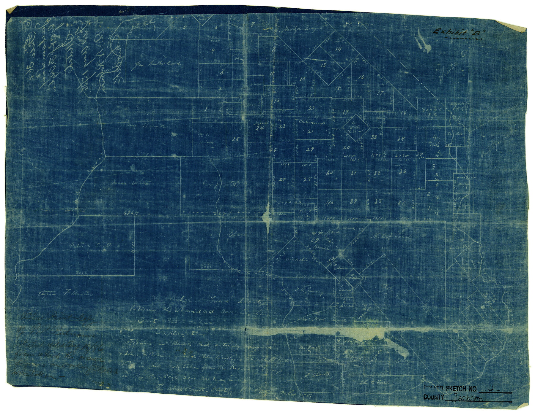
Jackson County Rolled Sketch 2
[Sketch of surveys east of Navidad River]
-
Map/Doc
6335
-
Collection
General Map Collection
-
Object Dates
8/18/1886 (File Date)
-
People and Organizations
P.P. Putnam (Surveyor/Engineer)
-
Counties
Jackson
-
Subjects
Surveying Rolled Sketch
-
Height x Width
14.1 x 17.9 inches
35.8 x 45.5 cm
-
Medium
blueprint/diazo
-
Comments
See Jackson County Sketch File 29 (27725) for field notes and report.
Related maps
Jackson County Sketch File 29

Print $10.00
- Digital $50.00
Jackson County Sketch File 29
Size 13.4 x 8.7 inches
Map/Doc 27725
Part of: General Map Collection
Flight Mission No. DQO-8K, Frame 9, Galveston County

Print $20.00
- Digital $50.00
Flight Mission No. DQO-8K, Frame 9, Galveston County
1952
Size 18.7 x 22.5 inches
Map/Doc 85132
Travis County Appraisal District Plat Map 2_1004

Print $20.00
- Digital $50.00
Travis County Appraisal District Plat Map 2_1004
Size 21.4 x 26.5 inches
Map/Doc 94238
Webb County Working Sketch 57

Print $20.00
- Digital $50.00
Webb County Working Sketch 57
1958
Size 24.9 x 38.0 inches
Map/Doc 72423
Travis County State Real Property Sketch 1

Print $20.00
- Digital $50.00
Travis County State Real Property Sketch 1
1985
Size 34.9 x 23.3 inches
Map/Doc 61691
Val Verde County Working Sketch 84

Print $20.00
- Digital $50.00
Val Verde County Working Sketch 84
1973
Size 45.4 x 33.0 inches
Map/Doc 72219
Dawson County Sketch File 2

Print $10.00
- Digital $50.00
Dawson County Sketch File 2
1907
Size 13.8 x 8.4 inches
Map/Doc 20498
El Paso County Rolled Sketch 46

Print $20.00
- Digital $50.00
El Paso County Rolled Sketch 46
1937
Size 38.6 x 30.3 inches
Map/Doc 5832
Brazos River, Brazos River Sheet 2

Print $20.00
- Digital $50.00
Brazos River, Brazos River Sheet 2
1926
Size 22.3 x 29.4 inches
Map/Doc 69666
Duval County Working Sketch 6

Print $20.00
- Digital $50.00
Duval County Working Sketch 6
1935
Size 26.9 x 21.8 inches
Map/Doc 68719
Coke County Working Sketch 18

Print $20.00
- Digital $50.00
Coke County Working Sketch 18
1948
Size 47.0 x 39.6 inches
Map/Doc 68055
Wise County Working Sketch 27

Print $20.00
- Digital $50.00
Wise County Working Sketch 27
1988
Size 28.0 x 37.2 inches
Map/Doc 72641
Palo Pinto County Working Sketch 25

Print $20.00
- Digital $50.00
Palo Pinto County Working Sketch 25
1991
Map/Doc 71408
You may also like
Val Verde County Sketch File 51c

Print $6.00
- Digital $50.00
Val Verde County Sketch File 51c
1959
Size 10.9 x 16.9 inches
Map/Doc 39332
Brewster County Rolled Sketch 156

Print $156.00
- Digital $50.00
Brewster County Rolled Sketch 156
2005
Map/Doc 85390
Mills County Boundary File 3

Print $30.00
- Digital $50.00
Mills County Boundary File 3
Size 11.0 x 8.6 inches
Map/Doc 57281
Milam County Sketch File 3

Print $4.00
- Digital $50.00
Milam County Sketch File 3
1853
Size 12.9 x 8.1 inches
Map/Doc 31628
Madison County Working Sketch 15

Print $20.00
- Digital $50.00
Madison County Working Sketch 15
2009
Size 42.3 x 36.0 inches
Map/Doc 89019
Clay County Sketch File 4

Print $22.00
- Digital $50.00
Clay County Sketch File 4
1854
Size 5.0 x 7.5 inches
Map/Doc 18392
Montague County Working Sketch 12

Print $20.00
- Digital $50.00
Montague County Working Sketch 12
1937
Size 23.3 x 23.8 inches
Map/Doc 71078
Archer County

Print $20.00
- Digital $50.00
Archer County
1926
Size 43.8 x 38.7 inches
Map/Doc 77202
Thomas Ross Survey

Print $20.00
- Digital $50.00
Thomas Ross Survey
1954
Size 16.8 x 17.6 inches
Map/Doc 92181
Crosby County Working Sketch 7

Print $20.00
- Digital $50.00
Crosby County Working Sketch 7
1938
Size 33.8 x 21.6 inches
Map/Doc 68441
Bee County Working Sketch 29b

Print $20.00
- Digital $50.00
Bee County Working Sketch 29b
1988
Size 34.4 x 36.3 inches
Map/Doc 67280
Brewster County Sketch File N-25

Print $28.00
- Digital $50.00
Brewster County Sketch File N-25
1952
Size 24.4 x 9.1 inches
Map/Doc 15700