Orange County Sketch File 36
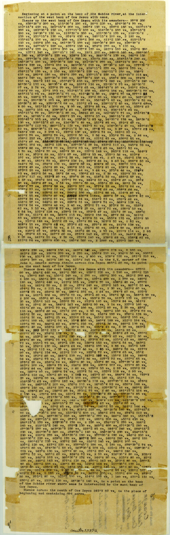
[Field notes of the meanders of Cow Bayou from the Sabine River to NW corner of J.M. Henrie survey]
-
Map/Doc
33372
-
Collection
General Map Collection
-
Object Dates
5/19/1919 (File Date)
-
People and Organizations
C.R. Goodman (Surveyor/Engineer)
-
Counties
Orange
-
Subjects
Surveying Sketch File
-
Height x Width
27.7 x 8.8 inches
70.4 x 22.4 cm
-
Medium
paper, print
-
Comments
See Orange County Rolled Sketch RG (9654) for sketch.
-
Features
Cow Bayou
Sabine River
Related maps
Orange County Rolled Sketch RG

Print $40.00
- Digital $50.00
Orange County Rolled Sketch RG
1919
Size 32.7 x 61.2 inches
Map/Doc 9654
Part of: General Map Collection
[Sketch showing University Lands in West Texas]
![62964, [Sketch showing University Lands in West Texas], General Map Collection](https://historictexasmaps.com/wmedia_w700/maps/62964-1.tif.jpg)
Print $20.00
- Digital $50.00
[Sketch showing University Lands in West Texas]
Size 20.5 x 27.8 inches
Map/Doc 62964

Sabine and Neches Rivers

Print $20.00
- Digital $50.00
Sabine and Neches Rivers
Size 19.6 x 43.7 inches
Map/Doc 94444
Gaines County Rolled Sketch 30

Print $20.00
- Digital $50.00
Gaines County Rolled Sketch 30
1962
Size 19.4 x 26.3 inches
Map/Doc 5943
Cass County Working Sketch 9

Print $20.00
- Digital $50.00
Cass County Working Sketch 9
1937
Size 28.4 x 32.7 inches
Map/Doc 67912
Collingsworth County Sketch File 4

Print $20.00
- Digital $50.00
Collingsworth County Sketch File 4
1889
Size 23.4 x 31.3 inches
Map/Doc 11131
Hopkins County Working Sketch 4

Print $20.00
- Digital $50.00
Hopkins County Working Sketch 4
1959
Size 23.3 x 30.9 inches
Map/Doc 66229
Archer County Sketch File 26

Print $4.00
- Digital $50.00
Archer County Sketch File 26
1934
Size 9.7 x 4.4 inches
Map/Doc 13663
Galveston County Sketch File 27

Print $20.00
- Digital $50.00
Galveston County Sketch File 27
Size 18.3 x 30.0 inches
Map/Doc 11532
Flight Mission No. BQR-4K, Frame 72, Brazoria County

Print $20.00
- Digital $50.00
Flight Mission No. BQR-4K, Frame 72, Brazoria County
1952
Size 18.8 x 22.5 inches
Map/Doc 84005
Newton County Sketch File 13

Print $22.00
- Digital $50.00
Newton County Sketch File 13
Size 8.1 x 12.7 inches
Map/Doc 32386
Carta Etnografica

Print $20.00
- Digital $50.00
Carta Etnografica
1897
Size 26.2 x 34.1 inches
Map/Doc 96798
You may also like
[Portions of Blocks 20, 24, S, and the West Lone of Wilson County School Land]
![91326, [Portions of Blocks 20, 24, S, and the West Lone of Wilson County School Land], Twichell Survey Records](https://historictexasmaps.com/wmedia_w700/maps/91326-1.tif.jpg)
Print $20.00
- Digital $50.00
[Portions of Blocks 20, 24, S, and the West Lone of Wilson County School Land]
1910
Size 27.9 x 15.7 inches
Map/Doc 91326
Pecos County Working Sketch 141

Print $20.00
- Digital $50.00
Pecos County Working Sketch 141
1941
Size 31.8 x 42.5 inches
Map/Doc 9733
Wise County Working Sketch 20

Print $20.00
- Digital $50.00
Wise County Working Sketch 20
1979
Size 22.8 x 27.3 inches
Map/Doc 72634
General Highway Map, Donley County, Texas

Print $20.00
General Highway Map, Donley County, Texas
1961
Size 24.4 x 18.3 inches
Map/Doc 79445
King County Survey

Print $20.00
- Digital $50.00
King County Survey
1916
Size 25.4 x 30.1 inches
Map/Doc 91020
Stonewall County Boundary File 3

Print $54.00
- Digital $50.00
Stonewall County Boundary File 3
Size 9.2 x 8.0 inches
Map/Doc 58961
Deaf Smith County Working Sketch Graphic Index

Print $40.00
- Digital $50.00
Deaf Smith County Working Sketch Graphic Index
1926
Size 40.1 x 52.6 inches
Map/Doc 76519
Flight Mission No. BQR-7K, Frame 24, Brazoria County

Print $20.00
- Digital $50.00
Flight Mission No. BQR-7K, Frame 24, Brazoria County
1952
Size 18.6 x 22.2 inches
Map/Doc 84022

Edwards County Rolled Sketch 27

Print $20.00
- Digital $50.00
Edwards County Rolled Sketch 27
1959
Size 18.0 x 33.2 inches
Map/Doc 5813
Jack County Working Sketch 12

Print $20.00
- Digital $50.00
Jack County Working Sketch 12
1959
Size 18.0 x 22.4 inches
Map/Doc 66438
Shackelford County Working Sketch 1

Print $20.00
- Digital $50.00
Shackelford County Working Sketch 1
Size 15.1 x 18.4 inches
Map/Doc 63841